Talbot-Inseln
| Talbot-Inseln | ||||||
|---|---|---|---|---|---|---|
| Gewässer | Pazifischer Ozean | |||||
| Archipel | Torres-Strait-Inseln | |||||
| Geographische Lage | 9° 15′ S, 142° 13′ O
{{#coordinates:−9,2569694444444|142,21875|primary
|
dim= | globe= | name=Talbot-Inseln | region=AU-QLD | type=isle
}} |
|
| ||||||
| Anzahl der Inseln | 11 (3 Hauptinseln) | |||||
| Hauptinsel | Boigu | |||||
| Gesamte Landfläche | 107,26 km² | |||||
| Einwohner | 283 | |||||
.png)
![[[Hilfe:Cache|Fehler beim Thumbnail-Erstellen]]:](/index.php/Datei:Red_pog.svg)
Die Talbot-Inseln sind eine Inselgruppe im Archipel der Torres-Strait-Inseln. Sie liegen wenige Kilometer vor der Südküste von Papua-Neuguinea in Höhe der Mündung des Mai Kussa River. Bis auf die ganz in Küstennähe gelegenen Inseln gehören sie zum australischen Bundesstaat Queensland.
Die Hauptinsel Boigu hatte 2006 271 Einwohner<ref>Census QuickStats: Boigu Island. Australian Bureau of Statistics, 2016, abgerufen am 1. März 2022 (Lua-Fehler in Modul:Multilingual, Zeile 153: attempt to index field 'data' (a nil value)).</ref>; alle anderen Inseln der Gruppe sind unbewohnt.
Tabelle der Inseln
Zu den Talbot-Inseln gehören vor allem folgende Inseln:
| Inselname | Provinz (Staat) | Einwohner | Fläche km² |
Geokoordinaten | |||||
|---|---|---|---|---|---|---|---|---|---|
| (Athian Maza) | Westprovinz (PNG) | unbewohnt | - | 09° 13′ S, 142° 17′ O
{{#coordinates:−9,2122222222222|142,2825|
|
dim= | globe= | name=Athian Maza | region=PG-WPD | type=isle
}} |
| Aubusi | Queensland (AUS) | unbewohnt | 5,80 | 09° 14′ S, 142° 10′ O
{{#coordinates:−9,2344444444444|142,17027777778|
|
dim= | globe= | name=Abusi | region=AU-QLD | type=isle
}} |
| Aymermud | Queensland (AUS) | unbewohnt | 0,70 | 09° 14′ S, 142° 09′ O
{{#coordinates:−9,2320194444444|142,15565|
|
dim= | globe= | name=Aymermud | region=AU-QLD | type=isle
}} |
| Boigu | Queensland (AUS) | 271 | 72,32 | 09° 16′ S, 142° 13′ O
{{#coordinates:−9,2623055555556|142,21429722222|
|
dim= | globe= | name=Boigu | region=AU-QLD | type=isle
}} |
| Kawai-Inseln | Westprovinz (PNG) | unbewohnt | 20,66 | 09° 11′ S, 142° 00′ O
{{#coordinates:−9,1905555555556|141,99416666667|
|
dim= | globe= | name=Kawai | region=PG-WPD | type=isle
}} |
| Kussa | Westprovinz (PNG) | unbewohnt | 4,90 | 09° 12′ S, 142° 18′ O
{{#coordinates:−9,2047222222222|142,29277777778|
|
dim= | globe= | name=Kussa | region=PG-WPD | type=isle
}} |
| Moegina Kawa | Queensland (AUS) | unbewohnt | 0,38 | 09° 14′ S, 142° 09′ O
{{#coordinates:−9,2295861111111|142,14611666667|
|
dim= | globe= | name=Moegina Kawa | region=AU-QLD | type=isle
}} |
| Moimi | Queensland (AUS) | unbewohnt | 2,06 | 09° 14′ S, 142° 14′ O
{{#coordinates:−9,2290722222222|142,24135|
|
dim= | globe= | name=Moimi | region=AU-QLD | type=isle
}} |
| Yaperi | Westprovinz (PNG) | unbewohnt | 0,10 | 09° 13′ S, 142° 22′ O
{{#coordinates:−9,2119444444444|142,37111111111|
|
dim= | globe= | name=Yaperi | region=PG-WPD | type=isle
}} |
Anmerkung: In der Tabelle sind die unbenannten Inseln westlich von Aubusi Island (auf 9° 13′ 50″ S, 142° 9′ 4″ O
{{#coordinates:−9,2305027777778|142,15110277778|
|dim=2000
|globe=
|name=unbenannt
|region=AU-QLD
|type=isle
}}) und Aymermud (auf 9° 13′ 50″ S, 142° 9′ 4″ O
{{#coordinates:−9,2305027777778|142,15110277778|
|dim=2000
|globe=
|name=unbenannt
|region=AU-QLD
|type=isle
}}) mit einer Fläche von zusammen etwa 27 ha nicht enthalten.
Politik
Verwaltungsmäßig zählen die australischen Inseln zu den Top Western Islands, einer Inselregion im Verwaltungsbezirk Torres Shire von Queensland. Die restlichen Inseln gehören zur Westprovinz von Papua-Neuguinea.
Geschichte
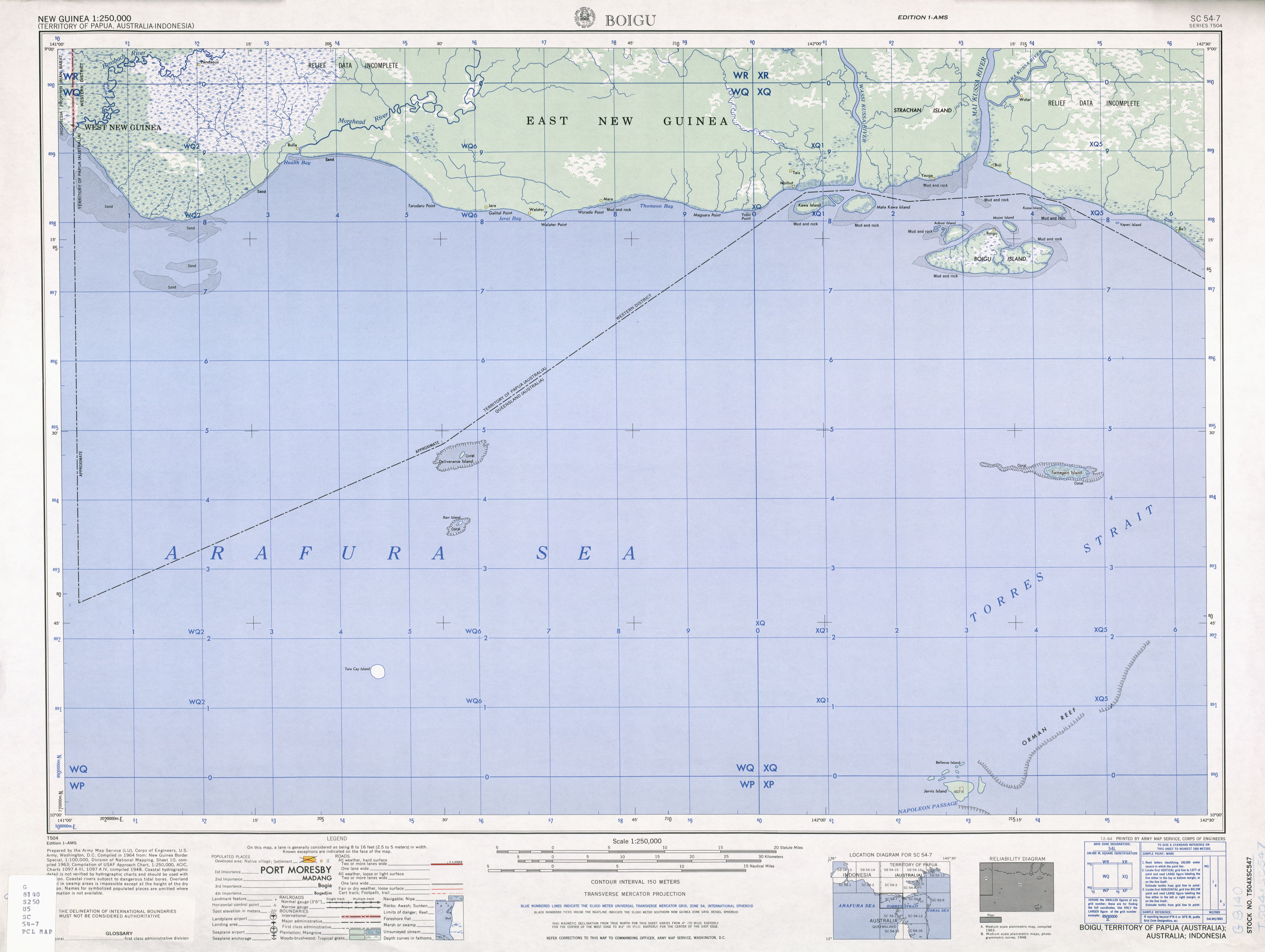
Die Kawai-Inseln, rund 10 km nordwestlich von Boigu und wenige hundert Meter von der Küste Neuguineas, gehören noch zu den Talbot-Inseln.<ref>Sailing Directions (enroute) Pub. 164 (PDF; 4,1 MB): The Kawaii Islands, constituting the rest of the group, are close off to the entrance to the Wassi Kussa River</ref> Diese Inseln, sowie Kussa Island nordöstlich der Gruppe, wurden im Torres Strait Treaty von 1978 an Papua-Neuguinea übergeben.<ref>http://www.austlii.edu.au/au/other/dfat/treaties/1985/4.html</ref> Bis dahin erschienen sie auf Karten als zu Australien gehörig.<ref>http://www.lib.utexas.edu/maps/ams/new_guinea/txu-oclc-6552576-sc54-7.jpg</ref>
Siehe auch
Einzelnachweise
<references />
Weblinks
Vorlage:Klappleiste/Anfang zum South Fly District der Westprovinz Papua-Neuguineas gehörige Torres-Strait-Inseln: Bristow Island | Daru Island | Parama Island • Kawai-Inseln | Talbot-Inseln
Top Western: Boigu | Dauan | Deliverance | Kerr | Saibai | Turnagain | Turu Cay • Talbot-Inseln
Western: Badu | Mabuiag | Moa | Portlock | Tobin • Bellevue-Inseln | Duncan-Inseln | Farewell-Inseln | Kulbi-Inseln
Central: Aureed | Bourke | Coconut | Gabba | Halfway | Sassie | Sue | Yam | Yorke | Zagai • Bourke-Inseln | Tetley-Inseln | The Three Sisters | Yorke-Inseln
Eastern: Bramble | Darnley | Murray | Stephens • Murray-Inseln
Inner: Albany | Booby | Crab | Entrance | Friday | Goods | Hammond | Horn | Packe | Port Lihou | Prince-of-Wales | Thursday | Trochus | Turtle Head | Turtle | Wednesday • Manar-Inseln | Red-Wallis-Inseln | Thursday-Inseln | Tuesday-Inseln Vorlage:Klappleiste/Ende