Zum Inhalt springen

Kawai-Inseln

aus Wikipedia, der freien Enzyklopädie
{{#if: Kawai Islands (Landsat).png| {{#if: Pazifischer Ozean| {{#if: Torres-Strait-Inseln| {{#if:| }} }} }} {{#if: 3| {{#if: Kawa Island| {{#if: 20.66| {{#if: 0| {{#if: TorresStraitIslandsMap.png|
{{#if:|{{{Name}}}|{{#invoke:WLink|getArticleBase}}}}
Datei:Kawai Islands (Landsat).png
Landsat-Bild der Gruppe

}}

Gewässer {{#ifexist: Pazifischer Ozean|[[Pazifischer Ozean]]|Pazifischer Ozean}} {{#if:2447756 colspan="2" | Pflichtparameter GEWAESSER fehlt }}

}}

Archipel {{#ifexist: Torres-Strait-Inseln|[[Torres-Strait-Inseln]]|Torres-Strait-Inseln}}

}}

1|1}}|{{#switch:{{Info ISO-3166-2:{{#titleparts:PG-WPD|1|1}}|level}} 1|2={{Info ISO-3166-2:{{#titleparts:PG-WPD|1|1}}|{{#switch:top 1|1}}|level}} adm2nd=2 adm1st=1 country=0 #default=top
 }}
}}
#default={{#switch: top continent = level = maxlevel = acronym = top = ?? upper = admtype = admtypelink = admname = lemma = 0 = 1 = 2 = map = Erde flag = Flag of None.svg

}} }}}}

LI|CH|GB={{#switch:{{#if:{{#titleparts:PG-WPD|1|2}}|{{#switch:{{Info ISO-3166-2:{{#titleparts:PG-WPD|1|2}}|level}} 1|2={{Info ISO-3166-2:{{#titleparts:PG-WPD|1|2}}|{{#switch:top 1|2}}|level}} adm2nd=2 adm1st=1 country=0 #default=top
 }}
}}
#default={{#switch: top continent = level = maxlevel = acronym = top = ?? upper = admtype = admtypelink = admname = lemma = 0 = 1 = 2 = map = Erde flag = Flag of None.svg

}} }}}}

LI|CH|GB={{#switch:{{#if:{{#titleparts:PG-WPD|1|3}}|{{#switch:{{Info ISO-3166-2:{{#titleparts:PG-WPD|1|3}}|level}} 1|2={{Info ISO-3166-2:{{#titleparts:PG-WPD|1|3}}|{{#switch:top 1|3}}|level}} adm2nd=2 adm1st=1 country=0 #default=top
 }}
}}
#default={{#switch: top continent = level = maxlevel = acronym = top = ?? upper = admtype = admtypelink = admname = lemma = 0 = 1 = 2 = map = Erde flag = Flag of None.svg

}} }}}}

CH|GB={{#switch:{{#if:{{#titleparts:PG-WPD|1|4}}|{{#switch:{{Info ISO-3166-2:{{#titleparts:PG-WPD|1|4}}|level}} 1|2={{Info ISO-3166-2:{{#titleparts:PG-WPD|1|4}}|{{#switch:top 1|4}}|level}} adm2nd=2 adm1st=1 country=0 #default=top
 }}
}}
#default={{#switch: top continent = level = maxlevel = acronym = top = ?? upper = admtype = admtypelink = admname = lemma = 0 = 1 = 2 = map = Erde flag = Flag of None.svg

}} }}}}||LI|CH|GB=|#default=DMS/}}

#default=DMS/}} #default=DMS/}} #default=DMS/}}{{#switch:CH 1|1}}|{{#switch:{{Info ISO-3166-2:{{#titleparts:PG-WPD|1|1}}|level}} 1|2={{Info ISO-3166-2:{{#titleparts:PG-WPD|1|1}}|{{#switch:top 1|1}}|level}} adm2nd=2 adm1st=1 country=0 #default=top
 }}
}}
#default={{#switch: top continent = level = maxlevel = acronym = top = ?? upper = admtype = admtypelink = admname = lemma = 0 = 1 = 2 = map = Erde flag = Flag of None.svg

}} }}}}

1|2}}|{{#switch:{{Info ISO-3166-2:{{#titleparts:PG-WPD|1|2}}|level}} 1|2={{Info ISO-3166-2:{{#titleparts:PG-WPD|1|2}}|{{#switch:top 1|2}}|level}} adm2nd=2 adm1st=1 country=0 #default=top
 }}
}}
#default={{#switch: top continent = level = maxlevel = acronym = top = ?? upper = admtype = admtypelink = admname = lemma = 0 = 1 = 2 = map = Erde flag = Flag of None.svg

}} }}}}

1|3}}|{{#switch:{{Info ISO-3166-2:{{#titleparts:PG-WPD|1|3}}|level}} 1|2={{Info ISO-3166-2:{{#titleparts:PG-WPD|1|3}}|{{#switch:top 1|3}}|level}} adm2nd=2 adm1st=1 country=0 #default=top
 }}
}}
#default={{#switch: top continent = level = maxlevel = acronym = top = ?? upper = admtype = admtypelink = admname = lemma = 0 = 1 = 2 = map = Erde flag = Flag of None.svg

}} }}}}

1|4}}|{{#switch:{{Info ISO-3166-2:{{#titleparts:PG-WPD|1|4}}|level}} 1|2={{Info ISO-3166-2:{{#titleparts:PG-WPD|1|4}}|{{#switch:top 1|4}}|level}} adm2nd=2 adm1st=1 country=0 #default=top
 }}
}}
#default={{#switch: top continent = level = maxlevel = acronym = top = ?? upper = admtype = admtypelink = admname = lemma = 0 = 1 = 2 = map = Erde flag = Flag of None.svg

}} }}}}=CH1903/CH1903

#default={{#switch:LI 1|1}}|{{#switch:{{Info ISO-3166-2:{{#titleparts:PG-WPD|1|1}}|level}} 1|2={{Info ISO-3166-2:{{#titleparts:PG-WPD|1|1}}|{{#switch:top 1|1}}|level}} adm2nd=2 adm1st=1 country=0 #default=top
 }}
}}
#default={{#switch: top continent = level = maxlevel = acronym = top = ?? upper = admtype = admtypelink = admname = lemma = 0 = 1 = 2 = map = Erde flag = Flag of None.svg

}} }}}}

1|2}}|{{#switch:{{Info ISO-3166-2:{{#titleparts:PG-WPD|1|2}}|level}} 1|2={{Info ISO-3166-2:{{#titleparts:PG-WPD|1|2}}|{{#switch:top 1|2}}|level}} adm2nd=2 adm1st=1 country=0 #default=top
 }}
}}
#default={{#switch: top continent = level = maxlevel = acronym = top = ?? upper = admtype = admtypelink = admname = lemma = 0 = 1 = 2 = map = Erde flag = Flag of None.svg

}} }}}}

1|3}}|{{#switch:{{Info ISO-3166-2:{{#titleparts:PG-WPD|1|3}}|level}} 1|2={{Info ISO-3166-2:{{#titleparts:PG-WPD|1|3}}|{{#switch:top 1|3}}|level}} adm2nd=2 adm1st=1 country=0 #default=top
 }}
}}
#default={{#switch: top continent = level = maxlevel = acronym = top = ?? upper = admtype = admtypelink = admname = lemma = 0 = 1 = 2 = map = Erde flag = Flag of None.svg

}} }}}}

1|4}}|{{#switch:{{Info ISO-3166-2:{{#titleparts:PG-WPD|1|4}}|level}} 1|2={{Info ISO-3166-2:{{#titleparts:PG-WPD|1|4}}|{{#switch:top 1|4}}|level}} adm2nd=2 adm1st=1 country=0 #default=top
 }}
}}
#default={{#switch: top continent = level = maxlevel = acronym = top = ?? upper = admtype = admtypelink = admname = lemma = 0 = 1 = 2 = map = Erde flag = Flag of None.svg

}} }}}}=CH1903/CH1903

#default=DMS/DMS

}}}}

DMS/CH1903/CH1903={{#if:Geographische Lage|Geographische Lage|Koordinaten}}, (CH) CH1903/CH1903={{#if:Geographische Lage|Geographische Lage|Koordinaten}} OSGB36/OSGB36=Ordnance Survey GB UTM=UTM-Koordinaten #default={{#if:Geographische Lage|Geographische Lage|Koordinaten}}

}}

y|Simple|Complex}}|NS=9/11/26/S|EW=141/59/39/E|type=isle|region=PG-WPD|globe=|dim=|elevation=|pop=0|lw=|name={{#invoke:Coordinates/kml|kmlTitle|1={{#if: |{{{Name}}}|{{#invoke:WLink|getArticleBase}}}}}}|article={{#if: text=/|sortkey=|tooltip=|tooltipformat=|map=|mapsize=|maplevel=|maptype=|maplabel=|maplayer=|mapcaption=}}{{#if:|{{#switch:5 1 = Gradzahl-Fehler: {{#iferror:{{{1}}} NS: {{{1}}}
}} {{#iferror:
EW:
}}{{#switch:0
6|14=
}}
2 = nicht im Bereich von {{{1}}}{{#switch:0 6|14=
}}
3 = {{#switch: {{{type}}} state|adm1st|adm2nd|city|isle|airport|mountain|waterbody|forest|landmark= example={{#if: falscher Wert ›example‹ im Artikelnamensraum
 }}
kein Wert falscher Wert ›{{{type}}}‹
 }} in type-Parameter{{#switch:0
6|14=
 }}
}} {{#if: {{{rg}}}
region-Parameter fehlt{{#if: 6
 }}
}} {{#iferror: {{{elevation}}}
{{{elevation}}}{{#switch:0 6|14=
 }}
}} {{#iferror: {{{pop}}}
{{{pop}}}{{#switch:0 6|14=
 }}
}}
, 2:}}{{#if:|, 3:}}{{#if:|, 4:}} {{#if:|usw.}}{{#switch:0 6|14=
}}
8 = Parameter name fehlt in Fließtextkoordinate{{#switch:0 6|14=
}}
10= überflüssige Parameter #default=coordinates error

}}}}

[[Datei:|300px|zentriert|alt=|Karte von {{#if: Kawai-Inseln|Kawai-Inseln|Kawai-Inseln}}]] {{#switch: |none|keine|-= colspan="2" style="text-align:center; padding:0;" |
 {{ Positionskarte {{#if: ||ISO 3166-2 }}
1={{#if: {{#ifeq:/PG-WPD 1|{{#expr:1+1}}}} 1|{{#expr:1+1}}}}

}} }}

label= Kawai-Inseln {{{Name}}}|{{#invoke:WLink|getArticleBase}}}} position=none lat=9/11/26/S long=141/59/39/E pop=0 |elevation= |region=PG-WPD dim= width=300 border=none caption= marksize=8 maptype=relief
    }}
Anzahl der Inseln 3 {{#if:2447756 colspan="2" | Pflichtparameter INSELN fehlt }}

}}

Hauptinsel Kawa Island

}}

Gesamte Landfläche Masz}} {{#if:2447756 colspan="2" | Pflichtparameter FLAECHE fehlt }}

}}

Einwohner 0|unbewohnt{{#ifeq: | |}} |Vorlage:FormatNumDef {{#if:|({{{ZENSUS}}})}} }}

}}

Datei:TorresStraitIslandsMap.png
Lage der Torres-Strait-Inseln

}}

{{#if: 9/11/26/S |{{#if: PG-WPD||

}} {{#switch: |none|keine|-=

}}

}}{{#if: || {{#if: Pazifischer Ozean||}} }}{{#if: || {{#if: 20.66||}} }}{{#if: || {{#if: 3||}} }} 
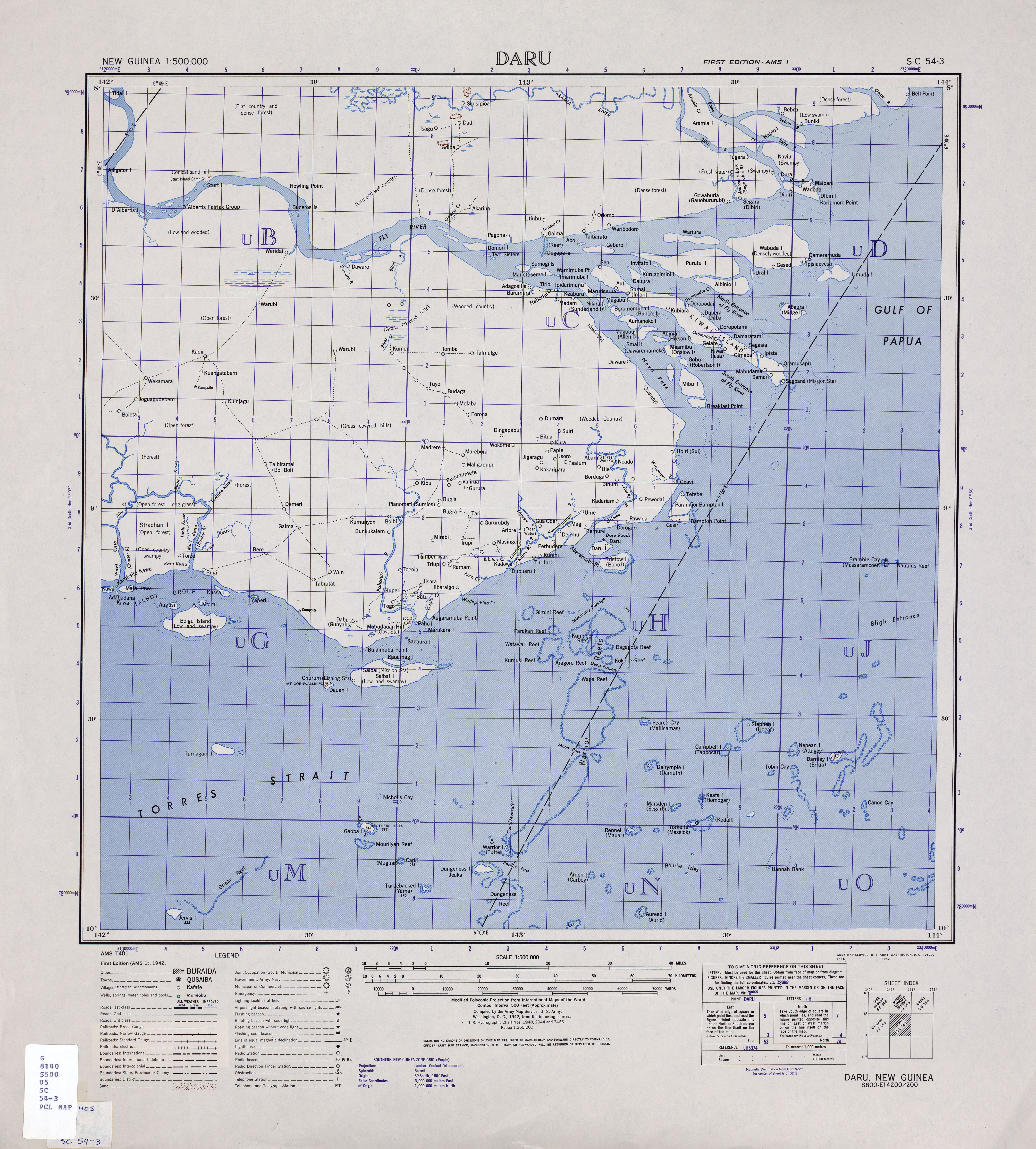
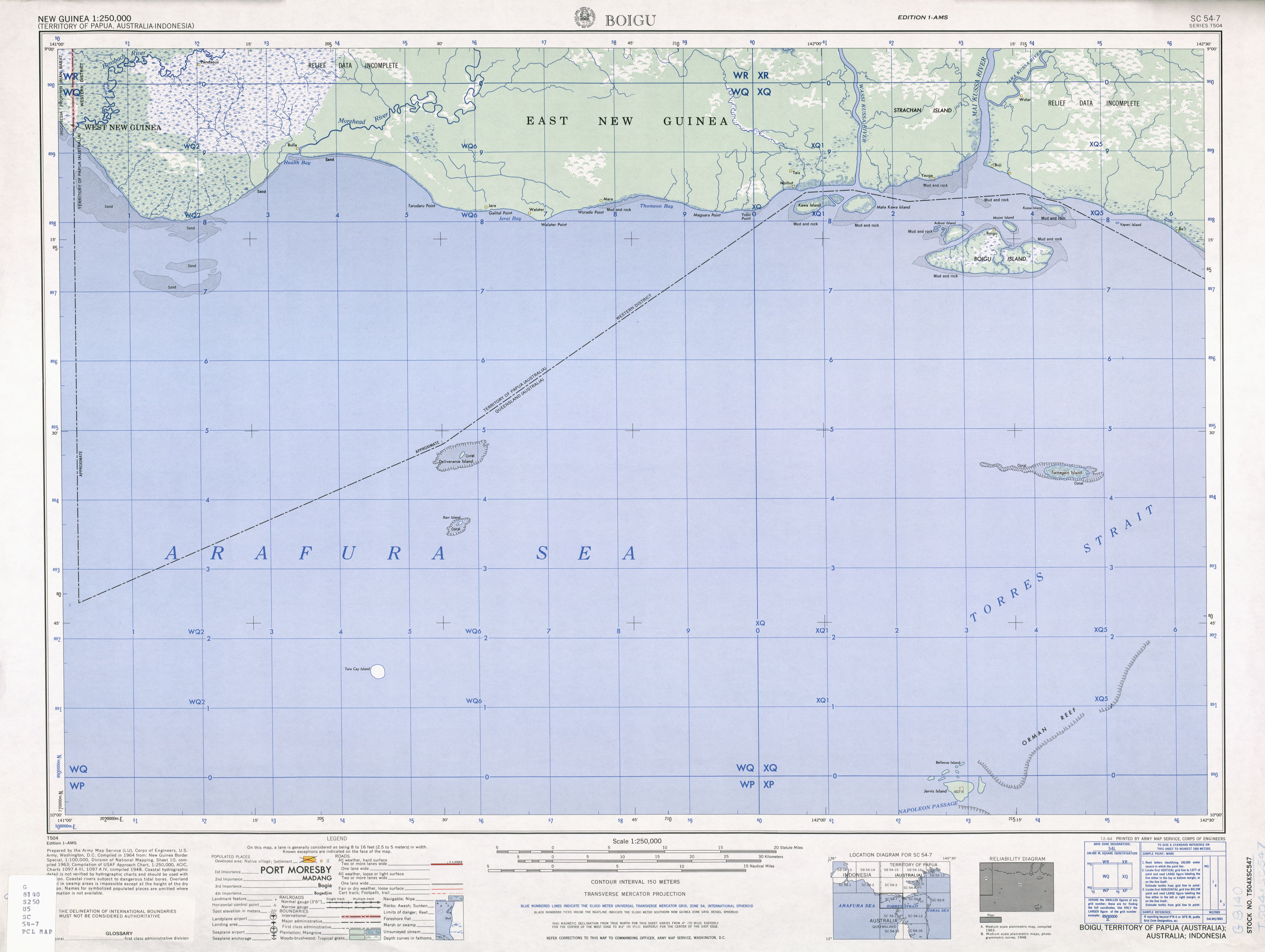
Die Kawai-Inseln sind eine Inselgruppe von Papua-Neuguinea. Sie gehören zu den nördlichsten Torres-Strait-Inseln und liegen nur wenige hundert Meter vor der Südküste Neuguineas bei der Mündung des Wassi Kussa River. Die Inseln sind flach, mangrovenbewachsen und unbewohnt. Von den ursprünglich vier Inseln, die noch auf einer Karte von 1942 verzeichnet sind,<ref>Scan einer Karte, 1:500.000, Dara, Mündung des Wassi Kussa River. lib.utexas.edu</ref> sind heute nur noch drei auf dem Satellitenbild auszumachen. Adabadana Kawa Island ist nicht mehr aufzufinden. Diese Insel fehlt bereits auf einer detaillierten Karte von 1948.<ref>Scan einer Karte, 1:250.000, Boigu (mit Kawai-Inseln). lib.utexas.edu</ref>

Es handelt sich um folgende Inseln:

Inselname Lage Fläche
km²
Geokoordinaten
Kawa Island Westen 9,69 y|Simple|Complex}}|NS=9/11/26/S|EW=141/59/39/E|type=isle|region=PG-WPD|globe=|dim=|elevation=|pop=|lw=|name={{#invoke:Coordinates/kml|kmlTitle|1=Kawa}}|article=|text=DMS|sortkey=EW|tooltip=|tooltipformat=|map=|mapsize=|maplevel=|maptype=|maplabel=|maplayer=|mapcaption=}}{{#if:|{{#switch:5 1 = Gradzahl-Fehler: {{#iferror:{{{1}}} NS: {{{1}}}
}} {{#iferror:
EW:
}}{{#switch:0
6|14=
}}
2 = nicht im Bereich von {{{1}}}{{#switch:0 6|14=
}}
3 = {{#switch: {{{type}}} state|adm1st|adm2nd|city|isle|airport|mountain|waterbody|forest|landmark= example={{#if: falscher Wert ›example‹ im Artikelnamensraum
 }}
kein Wert falscher Wert ›{{{type}}}‹
 }} in type-Parameter{{#switch:0
6|14=
 }}
}} {{#if: {{{rg}}}
region-Parameter fehlt{{#if: 6
 }}
}} {{#iferror: {{{elevation}}}
{{{elevation}}}{{#switch:0 6|14=
 }}
}} {{#iferror: {{{pop}}}
{{{pop}}}{{#switch:0 6|14=
 }}
}}
, 2:}}{{#if:|, 3:}}{{#if:|, 4:}} {{#if:|usw.}}{{#switch:0 6|14=
}}
8 = Parameter name fehlt in Fließtextkoordinate{{#switch:0 6|14=
}}
10= überflüssige Parameter #default=coordinates error

}}}}

Karobailo Kawa Island Norden 1,61 y|Simple|Complex}}|NS=9/11/0/S|EW=142/1/24/E|type=isle|region=PG-WPD|globe=|dim=|elevation=|pop=|lw=|name={{#invoke:Coordinates/kml|kmlTitle|1=Karobailo Kawa}}|article=|text=DMS|sortkey=EW|tooltip=|tooltipformat=|map=|mapsize=|maplevel=|maptype=|maplabel=|maplayer=|mapcaption=}}{{#if:|{{#switch:5 1 = Gradzahl-Fehler: {{#iferror:{{{1}}} NS: {{{1}}}
}} {{#iferror:
EW:
}}{{#switch:0
6|14=
}}
2 = nicht im Bereich von {{{1}}}{{#switch:0 6|14=
}}
3 = {{#switch: {{{type}}} state|adm1st|adm2nd|city|isle|airport|mountain|waterbody|forest|landmark= example={{#if: falscher Wert ›example‹ im Artikelnamensraum
 }}
kein Wert falscher Wert ›{{{type}}}‹
 }} in type-Parameter{{#switch:0
6|14=
 }}
}} {{#if: {{{rg}}}
region-Parameter fehlt{{#if: 6
 }}
}} {{#iferror: {{{elevation}}}
{{{elevation}}}{{#switch:0 6|14=
 }}
}} {{#iferror: {{{pop}}}
{{{pop}}}{{#switch:0 6|14=
 }}
}}
, 2:}}{{#if:|, 3:}}{{#if:|, 4:}} {{#if:|usw.}}{{#switch:0 6|14=
}}
8 = Parameter name fehlt in Fließtextkoordinate{{#switch:0 6|14=
}}
10= überflüssige Parameter #default=coordinates error

}}}}

(Adabadana Kawa Island) Süden y|Simple|Complex}}|NS=9/11/51/S|EW=142/1/22/E|type=isle|region=PG-WPD|globe=|dim=|elevation=|pop=|lw=|name={{#invoke:Coordinates/kml|kmlTitle|1=(Adabadana Kawa)}}|article=|text=DMS|sortkey=EW|tooltip=|tooltipformat=|map=|mapsize=|maplevel=|maptype=|maplabel=|maplayer=|mapcaption=}}{{#if:|{{#switch:5 1 = Gradzahl-Fehler: {{#iferror:{{{1}}} NS: {{{1}}}
}} {{#iferror:
EW:
}}{{#switch:0
6|14=
}}
2 = nicht im Bereich von {{{1}}}{{#switch:0 6|14=
}}
3 = {{#switch: {{{type}}} state|adm1st|adm2nd|city|isle|airport|mountain|waterbody|forest|landmark= example={{#if: falscher Wert ›example‹ im Artikelnamensraum
 }}
kein Wert falscher Wert ›{{{type}}}‹
 }} in type-Parameter{{#switch:0
6|14=
 }}
}} {{#if: {{{rg}}}
region-Parameter fehlt{{#if: 6
 }}
}} {{#iferror: {{{elevation}}}
{{{elevation}}}{{#switch:0 6|14=
 }}
}} {{#iferror: {{{pop}}}
{{{pop}}}{{#switch:0 6|14=
 }}
}}
, 2:}}{{#if:|, 3:}}{{#if:|, 4:}} {{#if:|usw.}}{{#switch:0 6|14=
}}
8 = Parameter name fehlt in Fließtextkoordinate{{#switch:0 6|14=
}}
10= überflüssige Parameter #default=coordinates error

}}}}

Mata Kawa Island Osten 9,36 y|Simple|Complex}}|NS=9/11/29/S|EW=142/3/2/E|type=isle|region=PG-WPD|globe=|dim=|elevation=|pop=|lw=|name={{#invoke:Coordinates/kml|kmlTitle|1=Mata Kawa}}|article=|text=DMS|sortkey=EW|tooltip=|tooltipformat=|map=|mapsize=|maplevel=|maptype=|maplabel=|maplayer=|mapcaption=}}{{#if:|{{#switch:5 1 = Gradzahl-Fehler: {{#iferror:{{{1}}} NS: {{{1}}}
}} {{#iferror:
EW:
}}{{#switch:0
6|14=
}}
2 = nicht im Bereich von {{{1}}}{{#switch:0 6|14=
}}
3 = {{#switch: {{{type}}} state|adm1st|adm2nd|city|isle|airport|mountain|waterbody|forest|landmark= example={{#if: falscher Wert ›example‹ im Artikelnamensraum
 }}
kein Wert falscher Wert ›{{{type}}}‹
 }} in type-Parameter{{#switch:0
6|14=
 }}
}} {{#if: {{{rg}}}
region-Parameter fehlt{{#if: 6
 }}
}} {{#iferror: {{{elevation}}}
{{{elevation}}}{{#switch:0 6|14=
 }}
}} {{#iferror: {{{pop}}}
{{{pop}}}{{#switch:0 6|14=
 }}
}}
, 2:}}{{#if:|, 3:}}{{#if:|, 4:}} {{#if:|usw.}}{{#switch:0 6|14=
}}
8 = Parameter name fehlt in Fließtextkoordinate{{#switch:0 6|14=
}}
10= überflüssige Parameter #default=coordinates error

}}}}

Die Kawai-Inseln gehören geographisch zu den etwa 10 km östlich gelegenen Talbot-Inseln, auch wenn sie im Torres Strait Treaty von 1978 von Australien an Papua-Neuguinea übergeben wurden.<ref>austlii.edu.au</ref>

Kawa (Plural Kawal) bedeutet „Insel“ in der Kala Kaiwau Ya-Sprache (Sprache der nordwestlichen Torres-Inseln). Der Namensbestandteil kommt auch in weiteren Inselnamen der unmittelbar benachbarten australischen Inselregion der Top Western Islands vor, so in Warul Kawa (Deliverance Island) und Moegina Kawa.

Siehe auch

Weblinks

Einzelnachweise

<references />

Vorlage:Hinweis Seiten-Koordinaten

{{safesubst:#ifeq:0|10| {{#switch: Kawai-Inseln |Navigationsleiste|NaviBlock|0=|#default= Vorlage:Templatetransclusioncheck Vorlage:Dokumentation/ruler }}}}Vorlage:Klappleiste/Anfang {{#if:

|

 |

zum South Fly District der Westprovinz Papua-Neuguineas gehörige Torres-Strait-Inseln:  Bristow Island | Daru Island | Parama Island  •  Kawai-Inseln | Talbot-Inseln

Top Western Boigu | Dauan | Deliverance | Kerr | Saibai | Turnagain | Turu Cay  •  Talbot-Inseln

Western Badu | Mabuiag | Moa | Portlock | Tobin  •  Bellevue-Inseln | Duncan-Inseln | Farewell-Inseln | Kulbi-Inseln

Central Aureed | Bourke | Coconut | Gabba | Halfway | Sassie | Sue | Yam | Yorke | Zagai  •  Bourke-Inseln | Tetley-Inseln | The Three Sisters | Yorke-Inseln

Eastern Bramble | Darnley | Murray | Stephens  •  Murray-Inseln

Inner Albany | Booby | Crab | Entrance | Friday | Goods | Hammond | Horn | Packe | Port Lihou | Prince-of-Wales | Thursday | Trochus | Turtle Head | Turtle | Wednesday  •  Manar-Inseln | Red-Wallis-Inseln | Thursday-Inseln | Tuesday-Inseln }} Vorlage:Klappleiste/Ende