Tanimbarinseln
{{#if: beschäftigt sich mit der Inselgruppe der Tanimbarinseln. Für den zugehörigen Regierungsbezirk siehe Tanimbarinseln (Regierungsbezirk).
| Vorlage:Hinweisbaustein | {{#ifeq: 0 | 0 |}}{{#if: Maluku Islands de.png| {{#if: Bandasee, Arafurasee| {{#if: Molukken| {{#if:| }} }} }} {{#if: 26| {{#if: Yamdena| {{#if: 5430| {{#if: | {{#if: |
| {{#if:|{{{Name}}}|{{#invoke:WLink|getArticleBase}}}} | |||||||||||||||||||||||||||||||||||||||||||||||||||||||||||||||||||||||||||||||||||||||||||||||||||||||||||||||||||||||||||||||||||||||||||||||||||||||||||||||||||||||||||||||||||||||||||||||||||||||||||||||||||||||||||||||||||||||||||||||||||||||||||||||||||||||||||||||||||||||||||||||||||||||||||||||||||||||||||||||||
|---|---|---|---|---|---|---|---|---|---|---|---|---|---|---|---|---|---|---|---|---|---|---|---|---|---|---|---|---|---|---|---|---|---|---|---|---|---|---|---|---|---|---|---|---|---|---|---|---|---|---|---|---|---|---|---|---|---|---|---|---|---|---|---|---|---|---|---|---|---|---|---|---|---|---|---|---|---|---|---|---|---|---|---|---|---|---|---|---|---|---|---|---|---|---|---|---|---|---|---|---|---|---|---|---|---|---|---|---|---|---|---|---|---|---|---|---|---|---|---|---|---|---|---|---|---|---|---|---|---|---|---|---|---|---|---|---|---|---|---|---|---|---|---|---|---|---|---|---|---|---|---|---|---|---|---|---|---|---|---|---|---|---|---|---|---|---|---|---|---|---|---|---|---|---|---|---|---|---|---|---|---|---|---|---|---|---|---|---|---|---|---|---|---|---|---|---|---|---|---|---|---|---|---|---|---|---|---|---|---|---|---|---|---|---|---|---|---|---|---|---|---|---|---|---|---|---|---|---|---|---|---|---|---|---|---|---|---|---|---|---|---|---|---|---|---|---|---|---|---|---|---|---|---|---|---|---|---|---|---|---|---|---|---|---|---|---|---|---|---|---|---|---|---|---|---|---|---|---|---|---|---|---|---|---|---|---|---|---|---|---|---|---|---|---|---|---|---|---|---|---|---|---|---|---|---|---|---|---|---|---|---|---|---|---|---|---|---|---|---|---|---|
}} | |||||||||||||||||||||||||||||||||||||||||||||||||||||||||||||||||||||||||||||||||||||||||||||||||||||||||||||||||||||||||||||||||||||||||||||||||||||||||||||||||||||||||||||||||||||||||||||||||||||||||||||||||||||||||||||||||||||||||||||||||||||||||||||||||||||||||||||||||||||||||||||||||||||||||||||||||||||||||||||||||
| Gewässer | {{#ifexist: Bandasee, Arafurasee|[[Bandasee, Arafurasee]]|Bandasee, Arafurasee}} | {{#if:400138 | colspan="2" | Pflichtparameter GEWAESSER fehlt }}
}} | ||||||||||||||||||||||||||||||||||||||||||||||||||||||||||||||||||||||||||||||||||||||||||||||||||||||||||||||||||||||||||||||||||||||||||||||||||||||||||||||||||||||||||||||||||||||||||||||||||||||||||||||||||||||||||||||||||||||||||||||||||||||||||||||||||||||||||||||||||||||||||||||||||||||||||||||||||||||||||||||
| Archipel | {{#ifexist: Molukken|[[Molukken]]|Molukken}}
}} | ||||||||||||||||||||||||||||||||||||||||||||||||||||||||||||||||||||||||||||||||||||||||||||||||||||||||||||||||||||||||||||||||||||||||||||||||||||||||||||||||||||||||||||||||||||||||||||||||||||||||||||||||||||||||||||||||||||||||||||||||||||||||||||||||||||||||||||||||||||||||||||||||||||||||||||||||||||||||||||||||
| 1|1}}|{{#switch:{{Info ISO-3166-2:{{#titleparts:ID-MA|1|1}}|level}} | 1|2={{Info ISO-3166-2:{{#titleparts:ID-MA|1|1}}|{{#switch:top | 1|1}}|level}} | adm2nd=2 | adm1st=1 | country=0 | #default=top
}} }} |
#default={{#switch: top | continent = | level = | maxlevel = | acronym = | top = ?? | upper = | admtype = | admtypelink = | admname = | lemma = | 0 = | 1 = | 2 = | map = Erde | flag = Flag of None.svg
}} }}}} |
LI|CH|GB={{#switch:{{#if:{{#titleparts:ID-MA|1|2}}|{{#switch:{{Info ISO-3166-2:{{#titleparts:ID-MA|1|2}}|level}} | 1|2={{Info ISO-3166-2:{{#titleparts:ID-MA|1|2}}|{{#switch:top | 1|2}}|level}} | adm2nd=2 | adm1st=1 | country=0 | #default=top
}} }} |
#default={{#switch: top | continent = | level = | maxlevel = | acronym = | top = ?? | upper = | admtype = | admtypelink = | admname = | lemma = | 0 = | 1 = | 2 = | map = Erde | flag = Flag of None.svg
}} }}}} |
LI|CH|GB={{#switch:{{#if:{{#titleparts:ID-MA|1|3}}|{{#switch:{{Info ISO-3166-2:{{#titleparts:ID-MA|1|3}}|level}} | 1|2={{Info ISO-3166-2:{{#titleparts:ID-MA|1|3}}|{{#switch:top | 1|3}}|level}} | adm2nd=2 | adm1st=1 | country=0 | #default=top
}} }} |
#default={{#switch: top | continent = | level = | maxlevel = | acronym = | top = ?? | upper = | admtype = | admtypelink = | admname = | lemma = | 0 = | 1 = | 2 = | map = Erde | flag = Flag of None.svg
}} }}}} |
CH|GB={{#switch:{{#if:{{#titleparts:ID-MA|1|4}}|{{#switch:{{Info ISO-3166-2:{{#titleparts:ID-MA|1|4}}|level}} | 1|2={{Info ISO-3166-2:{{#titleparts:ID-MA|1|4}}|{{#switch:top | 1|4}}|level}} | adm2nd=2 | adm1st=1 | country=0 | #default=top
}} }} |
#default={{#switch: top | continent = | level = | maxlevel = | acronym = | top = ?? | upper = | admtype = | admtypelink = | admname = | lemma = | 0 = | 1 = | 2 = | map = Erde | flag = Flag of None.svg
}} }}}}||LI|CH|GB=|#default=DMS/}} |
#default=DMS/}} | #default=DMS/}} | #default=DMS/}}{{#switch:CH | 1|1}}|{{#switch:{{Info ISO-3166-2:{{#titleparts:ID-MA|1|1}}|level}} | 1|2={{Info ISO-3166-2:{{#titleparts:ID-MA|1|1}}|{{#switch:top | 1|1}}|level}} | adm2nd=2 | adm1st=1 | country=0 | #default=top
}} }} |
#default={{#switch: top | continent = | level = | maxlevel = | acronym = | top = ?? | upper = | admtype = | admtypelink = | admname = | lemma = | 0 = | 1 = | 2 = | map = Erde | flag = Flag of None.svg
}} }}}} |
1|2}}|{{#switch:{{Info ISO-3166-2:{{#titleparts:ID-MA|1|2}}|level}} | 1|2={{Info ISO-3166-2:{{#titleparts:ID-MA|1|2}}|{{#switch:top | 1|2}}|level}} | adm2nd=2 | adm1st=1 | country=0 | #default=top
}} }} |
#default={{#switch: top | continent = | level = | maxlevel = | acronym = | top = ?? | upper = | admtype = | admtypelink = | admname = | lemma = | 0 = | 1 = | 2 = | map = Erde | flag = Flag of None.svg
}} }}}} |
1|3}}|{{#switch:{{Info ISO-3166-2:{{#titleparts:ID-MA|1|3}}|level}} | 1|2={{Info ISO-3166-2:{{#titleparts:ID-MA|1|3}}|{{#switch:top | 1|3}}|level}} | adm2nd=2 | adm1st=1 | country=0 | #default=top
}} }} |
#default={{#switch: top | continent = | level = | maxlevel = | acronym = | top = ?? | upper = | admtype = | admtypelink = | admname = | lemma = | 0 = | 1 = | 2 = | map = Erde | flag = Flag of None.svg
}} }}}} |
1|4}}|{{#switch:{{Info ISO-3166-2:{{#titleparts:ID-MA|1|4}}|level}} | 1|2={{Info ISO-3166-2:{{#titleparts:ID-MA|1|4}}|{{#switch:top | 1|4}}|level}} | adm2nd=2 | adm1st=1 | country=0 | #default=top
}} }} |
#default={{#switch: top | continent = | level = | maxlevel = | acronym = | top = ?? | upper = | admtype = | admtypelink = | admname = | lemma = | 0 = | 1 = | 2 = | map = Erde | flag = Flag of None.svg
}} }}}}=CH1903/CH1903 |
#default={{#switch:LI | 1|1}}|{{#switch:{{Info ISO-3166-2:{{#titleparts:ID-MA|1|1}}|level}} | 1|2={{Info ISO-3166-2:{{#titleparts:ID-MA|1|1}}|{{#switch:top | 1|1}}|level}} | adm2nd=2 | adm1st=1 | country=0 | #default=top
}} }} |
#default={{#switch: top | continent = | level = | maxlevel = | acronym = | top = ?? | upper = | admtype = | admtypelink = | admname = | lemma = | 0 = | 1 = | 2 = | map = Erde | flag = Flag of None.svg
}} }}}} |
1|2}}|{{#switch:{{Info ISO-3166-2:{{#titleparts:ID-MA|1|2}}|level}} | 1|2={{Info ISO-3166-2:{{#titleparts:ID-MA|1|2}}|{{#switch:top | 1|2}}|level}} | adm2nd=2 | adm1st=1 | country=0 | #default=top
}} }} |
#default={{#switch: top | continent = | level = | maxlevel = | acronym = | top = ?? | upper = | admtype = | admtypelink = | admname = | lemma = | 0 = | 1 = | 2 = | map = Erde | flag = Flag of None.svg
}} }}}} |
1|3}}|{{#switch:{{Info ISO-3166-2:{{#titleparts:ID-MA|1|3}}|level}} | 1|2={{Info ISO-3166-2:{{#titleparts:ID-MA|1|3}}|{{#switch:top | 1|3}}|level}} | adm2nd=2 | adm1st=1 | country=0 | #default=top
}} }} |
#default={{#switch: top | continent = | level = | maxlevel = | acronym = | top = ?? | upper = | admtype = | admtypelink = | admname = | lemma = | 0 = | 1 = | 2 = | map = Erde | flag = Flag of None.svg
}} }}}} |
1|4}}|{{#switch:{{Info ISO-3166-2:{{#titleparts:ID-MA|1|4}}|level}} | 1|2={{Info ISO-3166-2:{{#titleparts:ID-MA|1|4}}|{{#switch:top | 1|4}}|level}} | adm2nd=2 | adm1st=1 | country=0 | #default=top
}} }} |
#default={{#switch: top | continent = | level = | maxlevel = | acronym = | top = ?? | upper = | admtype = | admtypelink = | admname = | lemma = | 0 = | 1 = | 2 = | map = Erde | flag = Flag of None.svg
}} }}}}=CH1903/CH1903 |
#default=DMS/DMS
}}}} |
DMS/CH1903/CH1903={{#if:Geographische Lage|Geographische Lage|Koordinaten}}, (CH) | CH1903/CH1903={{#if:Geographische Lage|Geographische Lage|Koordinaten}} | OSGB36/OSGB36=Ordnance Survey GB | UTM=UTM-Koordinaten | #default={{#if:Geographische Lage|Geographische Lage|Koordinaten}}
}} |
y|Simple|Complex}}|NS=7/30//S|EW=131/30//E|type=isle|region=ID-MA|globe=|dim=|elevation=|pop=|lw=|name={{#invoke:Coordinates/kml|kmlTitle|1={{#if: |{{{Name}}}|{{#invoke:WLink|getArticleBase}}}}}}|article={{#if: | text=/|sortkey=|tooltip=|tooltipformat=|map=|mapsize=|maplevel=|maptype=|maplabel=|maplayer=|mapcaption=}}{{#if:|{{#switch:5 | 1 = Gradzahl-Fehler: {{#iferror:{{{1}}} | NS: {{{1}}} |
}} {{#iferror:
|
EW: |
}}{{#switch:0
|
6|14=
}} |
2 = nicht im Bereich von {{{1}}}{{#switch:0 | 6|14=
}} |
3 = {{#switch: {{{type}}} | state|adm1st|adm2nd|city|isle|airport|mountain|waterbody|forest|landmark= | example={{#if: | falscher Wert ›example‹ im Artikelnamensraum
}} |
kein Wert | falscher Wert ›{{{type}}}‹
}} in type-Parameter{{#switch:0 |
6|14=
}}
}} {{#if: {{{rg}}}
|
region-Parameter fehlt{{#if: |
}}
}} {{#iferror: {{{elevation}}}
|
{{{elevation}}}{{#switch:0 | 6|14=
}} |
}} {{#iferror: {{{pop}}}
|
{{{pop}}}{{#switch:0 | 6|14=
}} |
}} |
, 2:}}{{#if:|, 3:}}{{#if:|, 4:}} {{#if:|usw.}}{{#switch:0 | 6|14=
}} |
8 = Parameter name fehlt in Fließtextkoordinate{{#switch:0 | 6|14=
}} |
10= | #default=coordinates error
}}}} | |||||
| [[Datei:|300px|zentriert|alt=|Karte von {{#if: Tanimbarinseln|Tanimbarinseln|Tanimbarinseln}}]] | {{#switch: |none|keine|-= | colspan="2" style="text-align:center; padding:0;" |
{{ Positionskarte {{#if: ||ISO 3166-2 }}
|
1={{#if: | {{#ifeq:/ID-MA | 1|{{#expr:1+1}}}} | 1|{{#expr:1+1}}}}
}} }} |
label= Tanimbarinseln | {{{Name}}}|{{#invoke:WLink|getArticleBase}}}} | position=none | lat=7/30//S | long=131/30//E | pop= |elevation= |region=ID-MA | dim= | width=300 | border=none | caption= | marksize=35 | maptype=relief
}} | |||||||||||||||||||||||||||||||||||||||||||||||||||||||||||||||||||||||||||||||||||||||||||||||||||||||||||||||||||||||||||||||||||||||||||||||||||||||||||||||||||||||||||||||||||||||||||||||||||||||||||||||||||||||||||||||||||||||||||||||||||||||||||||||||||||||||||||||||||||||||||||||||||||||||||||||
| Anzahl der Inseln | 26 | {{#if:400138 | colspan="2" | Pflichtparameter INSELN fehlt }}
}} | ||||||||||||||||||||||||||||||||||||||||||||||||||||||||||||||||||||||||||||||||||||||||||||||||||||||||||||||||||||||||||||||||||||||||||||||||||||||||||||||||||||||||||||||||||||||||||||||||||||||||||||||||||||||||||||||||||||||||||||||||||||||||||||||||||||||||||||||||||||||||||||||||||||||||||||||||||||||||||||||
| Hauptinsel | Yamdena
}} | ||||||||||||||||||||||||||||||||||||||||||||||||||||||||||||||||||||||||||||||||||||||||||||||||||||||||||||||||||||||||||||||||||||||||||||||||||||||||||||||||||||||||||||||||||||||||||||||||||||||||||||||||||||||||||||||||||||||||||||||||||||||||||||||||||||||||||||||||||||||||||||||||||||||||||||||||||||||||||||||||
| Gesamte Landfläche | Masz}} | {{#if:400138 | colspan="2" | Pflichtparameter FLAECHE fehlt }}
}} | ||||||||||||||||||||||||||||||||||||||||||||||||||||||||||||||||||||||||||||||||||||||||||||||||||||||||||||||||||||||||||||||||||||||||||||||||||||||||||||||||||||||||||||||||||||||||||||||||||||||||||||||||||||||||||||||||||||||||||||||||||||||||||||||||||||||||||||||||||||||||||||||||||||||||||||||||||||||||||||||
| Einwohner | 0|unbewohnt{{#ifeq: | |}} |Vorlage:FormatNumDef {{#if:|()}} }}
}} | ||||||||||||||||||||||||||||||||||||||||||||||||||||||||||||||||||||||||||||||||||||||||||||||||||||||||||||||||||||||||||||||||||||||||||||||||||||||||||||||||||||||||||||||||||||||||||||||||||||||||||||||||||||||||||||||||||||||||||||||||||||||||||||||||||||||||||||||||||||||||||||||||||||||||||||||||||||||||||||||||
| [[Datei:|300px|zentriert|alt=|]]
}} | |||||||||||||||||||||||||||||||||||||||||||||||||||||||||||||||||||||||||||||||||||||||||||||||||||||||||||||||||||||||||||||||||||||||||||||||||||||||||||||||||||||||||||||||||||||||||||||||||||||||||||||||||||||||||||||||||||||||||||||||||||||||||||||||||||||||||||||||||||||||||||||||||||||||||||||||||||||||||||||||||
{{#if: 7/30//S |{{#if: ID-MA||
}} {{#switch: |none|keine|-=
}}
}}{{#if: || {{#if: Bandasee, Arafurasee||}} }}{{#if: || {{#if: 5430||}} }}{{#if: || {{#if: 26||}} }}
Die indonesische Inselgruppe Tanimbar (Bahasa Indonesia: kepulauan Tanimbar, veraltet Timorlaut) gehört zu den Molukken.
Geographie
Überblick
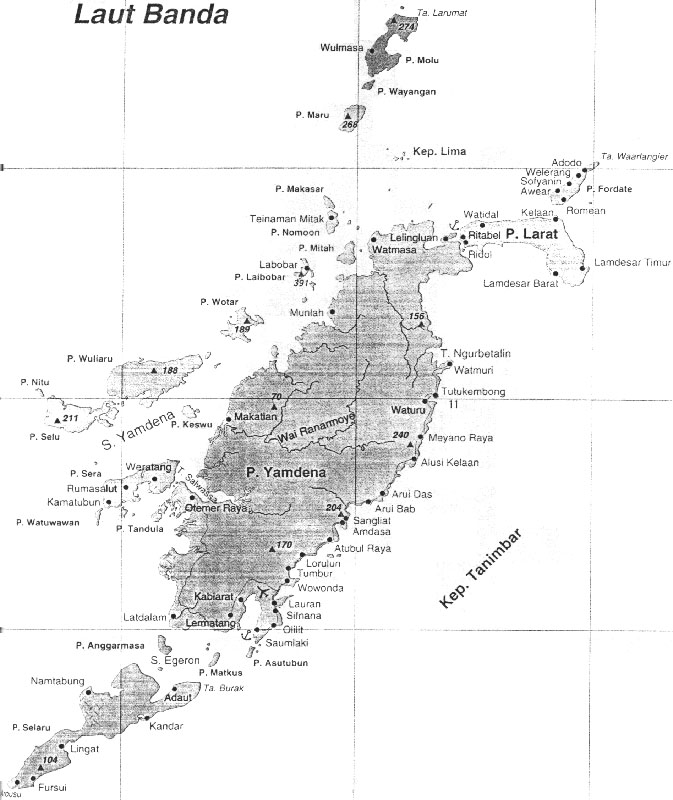
Die Tanimbarinseln liegen etwa auf halbem Weg zwischen Timor und Neuguinea. Nachbar im Westen sind die Babarinseln, nordöstlich befinden sich die Aru-Inseln und die Kei-Inseln. Gleichzeitig bilden sie das östliche Ende der Kleinen Sundainseln. Die Tanimbarinseln grenzen die Bandasee im Norden von der Arafurasee im Süden ab. Administrativ bildet die Inselgruppe den gleichnamigen Regierungsbezirk (Kabupaten) Tanimbarinseln der Provinz Maluku.<ref>Karte von Maluku Tenggara Barat</ref>
Hauptinsel des Archipels ist Yamdena (Nord-Timorlaut; 2.981 km²), um die sich südlich westlich und nördlich zahlreiche Inseln gruppieren. Südlich liegen Selaru (Süd-Timorlaut; 775 km²), Anggarmasa, Matkus, Nustabun, Nuyanat, Batbual und Asutubun, westlich Wuliaru (Waliaru, Wariaru; 220 km²), Selu (230 km²), Sera, Watuwawan, Tandula, Keswu, Nuswotar (Wotar) und Nitu und nördlich Larat (515 km²), Fordate, Laibobar, Mitah, Namoon, Makasar, die Lima-Inseln, Maru, Wayangan und Molu. Daneben gibt es weitere kleine Eilande.<ref>Karte der Tanimbarinseln</ref> Die Egeronstraße trennt Yamdena und Selaru, zwischen Yamdena und Wuliaru befindet sich die Yamdenastraße. Insgesamt beträgt die Landfläche 5.430 km².
Der höchste Gipfel der Inselgruppe liegt auf Laibobar und ist {{#ifeq: Vorlage:Höhe/Fmt|Expression error: Unrecognised punctuation character "."||}}{{#if: 391
|{{#if:
|{{#switch:
| AT = Vorlage:Höhe/Fmt {{#if:{{#invoke:TemplUtl|faculty|}}|m ü. A.|m ü. A.}}
| BSW77 =
{{#ifexpr: (391>=0)
|Vorlage:Höhe/Fmt m ü. {{#if:{{#invoke:TemplUtl|faculty|}}|Ostsee|Ostsee}}
|Vorlage:Höhe/Fmt m unter {{#if:{{#invoke:TemplUtl|faculty|}}|Ostsee|Ostsee}}
}}
| LI
| CH = Vorlage:Höhe/Fmt {{#if:{{#invoke:TemplUtl|faculty|}}|m ü. M.|m ü. M.}}
| LI-M
| CH-M = Vorlage:Höhe/Fmt {{#if:{{#invoke:TemplUtl|faculty|}}|m|m}}
| DE =
{{#ifexpr: (391>=0)
|Vorlage:Höhe/Fmt {{#if:{{#invoke:TemplUtl|faculty|}}|m|m}}
|Vorlage:Höhe/Fmt {{#if:{{#invoke:TemplUtl|faculty|}}|m unter dem Meeresspiegel|m unter dem Meeresspiegel}}
}}
| DE-NN =
{{#ifexpr: (391>=0)
|Vorlage:Höhe/Fmt m ü. {{#if:{{#invoke:TemplUtl|faculty|}}|NN|NN}}
|Vorlage:Höhe/Fmt m unter {{#if:{{#invoke:TemplUtl|faculty|}}|NN|NN}}
}}
| DE-HN =
{{#ifexpr: (391>=0)
|Vorlage:Höhe/Fmt m ü. {{#if:{{#invoke:TemplUtl|faculty|}}|HN|HN}}
|Vorlage:Höhe/Fmt m unter {{#if:{{#invoke:TemplUtl|faculty|}}|HN|HN}}
}}
| DE-NHN =
{{#ifexpr: (391>=0)
|Vorlage:Höhe/Fmt m ü. {{#if:{{#invoke:TemplUtl|faculty|}}|NHN|NHN}}
|Vorlage:Höhe/Fmt m unter {{#if:{{#invoke:TemplUtl|faculty|}}|NHN|NHN}}
}}
| DE-NHN-2016 =
{{#ifexpr: (391>=0)
|Vorlage:Höhe/Fmt m ü. {{#if:{{#invoke:TemplUtl|faculty|}}|NHN|NHN}}
|Vorlage:Höhe/Fmt m unter {{#if:{{#invoke:TemplUtl|faculty|}}|NHN|NHN}}
}}
|AL = Vorlage:Höhe/Fmt {{#if:{{#invoke:TemplUtl|faculty|}}|m ü. A.|m ü. A.}}
| SK = Vorlage:Höhe/Fmt {{#if:{{#invoke:TemplUtl|faculty|}}|m n.m.|m n.m.}}
| CZ = Vorlage:Höhe/Fmt {{#if:{{#invoke:TemplUtl|faculty|}}|m n.m.|m n.m.}}
| HU = Vorlage:Höhe/Fmt {{#if:{{#invoke:TemplUtl|faculty|}}|m|m}}
| DK = Vorlage:Höhe/Fmt {{#if:{{#invoke:TemplUtl|faculty|}}|m.o.h.|m.o.h.}}
| GB| IE = Vorlage:Höhe/Fmt {{#if:{{#invoke:TemplUtl|faculty|}}|m ASL|m ASL}}
| FR|FX = Vorlage:Höhe/Fmt {{#if:{{#invoke:TemplUtl|faculty|}}|m|m}}
| IT|SM|VA = Vorlage:Höhe/Fmt {{#if:{{#invoke:TemplUtl|faculty|}}|m s.l.m.|m s.l.m.}}
|BA
|HR
|ME
|MK
|RS
|SI
= Vorlage:Höhe/Fmt {{#if:{{#invoke:TemplUtl|faculty|}}|m. i. J.|m. i. J.}}
| JP = Vorlage:Höhe/Fmt {{#if:{{#invoke:TemplUtl|faculty|}}|m T.P.|m T.P.}}
| NL = Vorlage:Höhe/Fmt {{#if:{{#invoke:TemplUtl|faculty|}}|m NAP|m NAP}}
| NO =
{{#ifexpr: (391>=0)
|Vorlage:Höhe/Fmt {{#if:{{#invoke:TemplUtl|faculty|}}|moh.|moh.}}
|Vorlage:Höhe/Fmt {{#if:{{#invoke:TemplUtl|faculty|}}|muh.|muh.}}
}}
| PL = Vorlage:Höhe/Fmt {{#if:{{#invoke:TemplUtl|faculty|}}|m n.p.m.|m n.p.m.}}
| SE = Vorlage:Höhe/Fmt {{#if:{{#invoke:TemplUtl|faculty|}}|m ö.h.|m ö.h.}}
| ES = Vorlage:Höhe/Fmt {{#if:{{#invoke:TemplUtl|faculty|}}|msnm|msnm}}
| BE = Vorlage:Höhe/Fmt {{#if:{{#invoke:TemplUtl|faculty|}}|m O.P.|m O.P.}}
|AF
|AX
|DZ
|AS
|AD
|AO
|AI
|AQ
|AG
|AR
|AM
|AW
|AU
|AZ
|BS
|BH
|BD
|BB
|BY
|BZ
|BJ
|BM
|BT
|BO
|BW
|BV
|BR
|IO
|BN
|BG
|BF
|BI
|KH
|CM
|CA
|CV
|KY
|CF
|TD
|CL
|CN
|CX
|CC
|CO
|KM
|CG
|CD
|CK
|CR
|CI
|CU
|CY
|DK
|DJ
|DM
|DO
|EC
|EG
|SV
|GQ
|ER
|EE
|ET
|FK
|FO
|FJ
|FI
|GF
|PF
|TF
|GA
|GM
|GE
|GH
|GI
|GR
|GL
|GD
|GP
|GU
|GT
|GG
|GN
|GW
|GY
|HT
|HM
|HN
|HK
|IS
|IN
|ID
|IR
|IQ
|IM
|IL
|JM
|JE
|JO
|KZ
|KE
|KI
|KP
|KR
|KW
|KG
|LA
|LV
|LB
|LS
|LR
|LY
|LT
|LU
|MO
|MG
|MW
|MY
|MV
|ML
|MT
|MH
|MQ
|MR
|MU
|YT
|MX
|FM
|MD
|MC
|MN
|MS
|MA
|MZ
|MM
|NA
|NR
|NP
|AN
|NC
|NZ
|NI
|NE
|NG
|NU
|NF
|MP
|OM
|PK
|PW
|PS
|PA
|PG
|PY
|PE
|PH
|PN
|PT
|PR
|QA
|RE
|RO
|RU
|RW
|SH
|KN
|LC
|PM
|VC
|WS
|ST
|SA
|SN
|SC
|SL
|SG
|SB
|SO
|ZA
|GS
|LK
|SD
|SS
|SR
|SJ
|SZ
|SY
|TW
|TJ
|TZ
|TH
|TL
|TG
|TK
|TO
|TT
|TN
|TR
|TM
|TC
|TV
|UG
|UA
|AE
|US
|UM
|UY
|UZ
|VU
|VE
|VN
|VG
|VI
|WF
|EH
|YE
|ZM
|ZW
=
{{#ifexpr: (391>=0)
|Vorlage:Höhe/Fmt {{#if:{{#invoke:TemplUtl|faculty|}}|m|m}}
|Vorlage:Höhe/Fmt {{#if:{{#invoke:TemplUtl|faculty|}}|m unter dem Meeresspiegel|m unter dem Meeresspiegel}}
}}
|XA| XS| XN| XP| XI=
{{#ifexpr: (391>=0)
|Vorlage:Höhe/Fmt m ü. {{#if:{{#invoke:TemplUtl|faculty|}}|MSL|MSL}}
|Vorlage:Höhe/Fmt m unter {{#if:{{#invoke:TemplUtl|faculty|}}|MSL|MSL}}
}}
|XO=
{{#ifexpr: (391>=150)
|{{#invoke:Measure|Masz}} ü. {{#if:{{#invoke:TemplUtl|faculty|}}|MSL|MSL}}
|Vorlage:Höhe/ungültiger Wert
}}
|MERKUR| VENUS| ERDE| MARS| JUPITER| SATURN| URANUS| NEPTUN =
{{#ifexpr: (391>=0)
|Vorlage:Höhe/Fmt m ü. {{#if:{{#invoke:TemplUtl|faculty|}}|Nullniveau|Nullniveau}}
|Vorlage:Höhe/Fmt m unter {{#if:{{#invoke:TemplUtl|faculty|}}|Nullniveau|Nullniveau}}
}}
|M
|METER =
{{#ifexpr: (391>=0)
|Vorlage:Höhe/Fmt {{#if:{{#invoke:TemplUtl|faculty|}}|m|m}}
|Vorlage:Höhe/Fmt {{#if:{{#invoke:TemplUtl|faculty|}}|m unter dem Meeresspiegel|m unter dem Meeresspiegel}}
}}
| #default = Vorlage:Höhe/Fmt Vorlage:Höhe/unbekannter Bezug
}}
|{{#ifexpr: (391>=0)
|Vorlage:Höhe/Fmt {{#if:{{#invoke:TemplUtl|faculty|}}|m|m}}
|Vorlage:Höhe/Fmt {{#if:{{#invoke:TemplUtl|faculty|}}|m unter dem Meeresspiegel|m unter dem Meeresspiegel}}
}}
}}
| Höhenwert fehlt, siehe Vorlagenbeschreibung
}} hoch.<ref name="eth">Ethnologische Karte der Tanimbarinseln</ref>
Geologie
Die Tanimbarinseln sind aus tertiären Schichten aufgebaut und besitzen besonders im Westen zahlreiche Korallenriffe.
Fauna und Flora
Auf den Tanimbarinseln sind bereits starke Einflüsse der australischen Tier- und Pflanzenwelt zu beobachten. Einige Arten sind jedoch auf die Tanimbarinseln beschränkt. So kommt nur hier beispielsweise die sehr seltene Molukkeneule vor, für die bislang keinerlei Beobachtungen im Freiland vorliegen und die wissenschaftlich nur anhand von Bälgen beschrieben wurde.<ref> Claus König, Friedhelm Weick: Owls of the World. Christopher Helm, London 2008, ISBN 978-0-7136-6548-2, S. 222 </ref> Ebenfalls endemisch ist auf den Inseln der Goffinkakadu.
Bevölkerung
Die größte Stadt Saumlaki, mit etwa 10.000 Einwohnern, liegt auf der Hauptinsel Yamdena. Saumlaki besitzt auch einen kleinen, allerdings wenig frequentierten Flughafen sowie einen ausgebauten Hafen, der vor allem von der staatlichen Schifffahrtsgesellschaft Pelni angefahren wird.
Die traditionelle Bevölkerung teilt sich in vier Ethnien: Yamdena an der Ostküste der gleichnamigen Insel, Seluwasan an der Westküste, Fordata an der Nordküste und den vorgelagerten Inseln im Norden und Westen und Selaru auf der gleichnamigen Insel.<ref><templatestyles src="Webarchiv/styles.css" />{{#if:20151125012646
| {{#ifeq: 20151125012646 | *
| {{#if: Indonesia Traveling: Tanimbar | {{#invoke:WLink|getEscapedTitle|Indonesia Traveling: Tanimbar}} | {{#invoke:Webarchiv|getdomain|http://www.indonesiatraveling.com/moluccas/moluccas-intro-and-maps/7660-tanimbar-islands-map.html}} }} (Archivversionen)
| {{#iferror: {{#time: j. F Y|20151125012646}}
| {{#if: || }}Der Wert des Parameters {{#if: wayback | wayback | Datum }} muss ein gültiger Zeitstempel der Form YYYYMMDDHHMMSS sein!
| {{#if: Indonesia Traveling: Tanimbar | {{#invoke:WLink|getEscapedTitle|Indonesia Traveling: Tanimbar}} | {{#invoke:Webarchiv|getdomain|http://www.indonesiatraveling.com/moluccas/moluccas-intro-and-maps/7660-tanimbar-islands-map.html}} }} {{#ifeq: | [] | [ | ( }}{{#if: {{#if: 2018-12-05 17:07:05 InternetArchiveBot | 2018-12-05 17:07:05 InternetArchiveBot | }} | des Vorlage:Referrer }} vom {{#time: j. F Y|20151125012646}} im Internet Archive{{#if: | ; }}{{#ifeq: | [] | ] | ) }}
}}
}}
| {{#if:
| {{#iferror: {{#time: j. F Y|{{{webciteID}}}}}
| {{#switch: {{#invoke:Str|len|{{{webciteID}}}}}
| 16= {{#if: Indonesia Traveling: Tanimbar | {{#invoke:WLink|getEscapedTitle|Indonesia Traveling: Tanimbar}} | {{#invoke:Webarchiv|getdomain|http://www.indonesiatraveling.com/moluccas/moluccas-intro-and-maps/7660-tanimbar-islands-map.html}} }} {{#ifeq: | [] | [ | ( }}{{#if: {{#if: 2018-12-05 17:07:05 InternetArchiveBot | 2018-12-05 17:07:05 InternetArchiveBot | }} | des Vorlage:Referrer }} vom {{#time: j. F Y| 19700101000000 + {{#expr: floor {{#expr: {{#invoke:Str|sub|{{{webciteID}}}|1|10}}/86400}} }} days}} auf WebCite{{#if: | ; }}{{#ifeq: | [] | ] | ) }}
| 9 = {{#if: Indonesia Traveling: Tanimbar | {{#invoke:WLink|getEscapedTitle|Indonesia Traveling: Tanimbar}} | {{#invoke:Webarchiv|getdomain|http://www.indonesiatraveling.com/moluccas/moluccas-intro-and-maps/7660-tanimbar-islands-map.html}} }} {{#ifeq: | [] | [ | ( }}{{#if: {{#if: 2018-12-05 17:07:05 InternetArchiveBot | 2018-12-05 17:07:05 InternetArchiveBot | }} | des Vorlage:Referrer}} vom {{#time: j. F Y| 19700101000000 + {{#expr: floor {{#expr: {{#invoke:Str|sub|{{#invoke:Expr|base62|{{{webciteID}}}}}|1|10}}/86400}} }} days}} auf WebCite{{#if: | ; }}{{#ifeq: | [] | ] | ) }}
| #default= Der Wert des Parameters {{#if: webciteID | webciteID | ID }} muss entweder ein Zeitstempel der Form YYYYMMDDHHMMSS oder ein Schüsselwert mit 9 Zeichen oder eine 16-stellige Zahl sein!{{#if: || }}
}}
| c|{{{webciteID}}}}} {{#if: Indonesia Traveling: Tanimbar | {{#invoke:WLink|getEscapedTitle|Indonesia Traveling: Tanimbar}} | {{#invoke:Webarchiv|getdomain|http://www.indonesiatraveling.com/moluccas/moluccas-intro-and-maps/7660-tanimbar-islands-map.html}} }} ({{#if: {{#if: 2018-12-05 17:07:05 InternetArchiveBot | 2018-12-05 17:07:05 InternetArchiveBot | }} | des Vorlage:Referrer}} vom {{#time: j. F Y|{{{webciteID}}}}} auf WebCite{{#if: | ; }}{{#ifeq: | [] | ] | ) }}
}}
| {{#if:
| Vorlage:Webarchiv/Today
| {{#if:
| Vorlage:Webarchiv/Generisch
| {{#if: Indonesia Traveling: Tanimbar | {{#invoke:WLink|getEscapedTitle|Indonesia Traveling: Tanimbar}} | {{#invoke:Webarchiv|getdomain|http://www.indonesiatraveling.com/moluccas/moluccas-intro-and-maps/7660-tanimbar-islands-map.html}} }}
}}}}}}}}{{#if:2018-12-05 17:07:05 InternetArchiveBot
| Vorlage:Webarchiv/archiv-bot
}}{{#invoke:TemplatePar|check
|all = url=
|opt = text= wayback= webciteID= archive-is= archive-today= archiv-url= archiv-datum= ()= archiv-bot= format= original=
|cat = Wikipedia:Vorlagenfehler/Vorlage:Webarchiv
|errNS = 0
|template = Vorlage:Webarchiv
|format = *
|preview = 1
}}{{#ifexpr: {{#if:20151125012646|1|0}}{{#if:|+1}}{{#if:|+1}}{{#if:|+1}}{{#if:|+1}} <> 1
| {{#if: || }}{{#invoke:TemplUtl|failure| Fehler bei Vorlage:Webarchiv: Genau einer der Parameter 'wayback', 'webciteID', 'archive-today', 'archive-is' oder 'archiv-url' muss angegeben werden.|1}}
}}{{#if:
| {{#switch: {{#invoke:Webarchiv|getdomain|{{{archiv-url}}}}}
| web.archive.org =
{{#if: || }}{{#invoke:TemplUtl|failure| Fehler bei Vorlage:Webarchiv: Im Parameter 'archiv-url' wurde URL von Internet Archive erkannt, bitte Parameter 'wayback' benutzen.|1}}
| webcitation.org =
{{#if: || }}{{#invoke:TemplUtl|failure| Fehler bei Vorlage:Webarchiv: Im Parameter 'archiv-url' wurde URL von WebCite erkannt, bitte Parameter 'webciteID' benutzen.|1}}
| archive.today |archive.is |archive.ph |archive.fo |archive.li |archive.md |archive.vn =
{{#if: || }}{{#invoke:TemplUtl|failure| Fehler bei Vorlage:Webarchiv: Im Parameter 'archiv-url' wurde URL von archive.today erkannt, bitte Parameter 'archive-today' benutzen.|1}}
}}{{#if:
| {{#iferror: {{#iferror:{{#invoke:Vorlage:FormatDate|Execute}}|}}
| {{#if: || }}{{#invoke:TemplUtl|failure| Fehler bei Vorlage:Webarchiv: Der Wert des Parameter 'archiv-datum' ist ungültig oder hat ein ungültiges Format.|1}}
| }}
| {{#if: || }}{{#invoke:TemplUtl|failure| Fehler bei Vorlage:Webarchiv: Der Pflichtparameter 'archiv-datum' wurde nicht angegeben.|1}}
}}
| {{#if:
| {{#if: || }}{{#invoke:TemplUtl|failure| Fehler bei Vorlage:Webarchiv: Der Parameter 'archiv-datum' ist nur in Verbindung mit 'archiv-url' angebbar.|1}}
}}
}}{{#if:{{#invoke:URLutil|isHostPathResource|http://www.indonesiatraveling.com/moluccas/moluccas-intro-and-maps/7660-tanimbar-islands-map.html}}
|| {{#if: || }}
}}{{#if: Indonesia Traveling: Tanimbar
| {{#if: {{#invoke:WLink|isBracketedLink|Indonesia Traveling: Tanimbar}}
| {{#if: || }}
}}
| {{#if: || }}
}}{{#switch:
|addlarchives|addlpages= {{#if: || }}{{#if: 1 |}}{{#invoke:TemplUtl|failure| Fehler bei Vorlage:Webarchiv: enWP-Wert im Parameter 'format'.|1}}
}}{{#ifeq: {{#invoke:Str|find|http://www.indonesiatraveling.com/moluccas/moluccas-intro-and-maps/7660-tanimbar-islands-map.html%7Carchiv}} |-1
|| {{#ifeq: {{#invoke:Str|find|{{#invoke:Str|cropleft|http://www.indonesiatraveling.com/moluccas/moluccas-intro-and-maps/7660-tanimbar-islands-map.html%7C4}}%7Chttp}} |-1
|| {{#switch: {{#invoke:Webarchiv|getdomain|http://www.indonesiatraveling.com/moluccas/moluccas-intro-and-maps/7660-tanimbar-islands-map.html }}
| abendblatt.de | daserste.ndr.de | inarchive.com | webcitation.org =
| #default = {{#if: || }}{{#if: 1 |}}{{#invoke:TemplUtl|failure| Fehler bei Vorlage:Webarchiv: Archiv-URL im Parameter 'url' anstatt URL der Originalquelle. Entferne den vor der Original-URL stehenden Mementobestandteil und setze den Archivierungszeitstempel in den Parameter 'wayback', 'webciteID', 'archive.today' oder 'archive-is' ein, sofern nicht bereits befüllt.|1}}
}}
}}
}}</ref>
Aufgrund von Unruhen in Ambon flüchteten viele Christen nach Saumlaki. Die Bevölkerung setzt sich dort daher aus fast 100 % Protestanten zusammen.
Weblinks
|X|x= |0|-= |S|s= – Sammlung von Bildern |1|= – Sammlung von Bildern{{#if:
| {{#switch: {{#invoke:TemplUtl|faculty|1}}/{{#invoke:TemplUtl|faculty|1}}
|1/= und Videos
|1/1=, Videos und Audiodateien
|/1= und Audiodateien}}
| , Videos und Audiodateien
}}
|#default= – }}{{#if: Tanimbar Islands
| {{#ifeq: {{#invoke:Str|left|tanimbar islands|9}}
| category:
| FEHLER: Ohne Category: angeben!}}}}Vorlage:Wikidata-Registrierung
Einzelnachweise
<references/>
<templatestyles src="BoxenVerschmelzen/styles.css" />
{{#if:Navigationsleiste Tanimbarinseln |Vorlage:Navigationsleiste Tanimbarinseln}}{{#if:Navigationsleiste Inseln und Inselgruppen der Molukken|{{safesubst:#ifeq:0|10| {{#switch: Tanimbarinseln |Navigationsleiste|NaviBlock|0=|#default= Vorlage:Templatetransclusioncheck Vorlage:Dokumentation/ruler }}}}Vorlage:Klappleiste/Anfang {{#if:
|Nordgruppe: Bacaninseln | Goraici-Inseln | Halmahera | Morotai | Nördliche Loloda-Inseln | Obi-Inseln | Südliche Loloda-Inseln | Sula-Inseln | Ternate | Tidore
Südgruppe: Ambelau | Ambon | Aru-Inseln | Babarinseln | Banda-Inseln | Barat-Daya-Inseln (mit Wetar) | Buru | Gorominseln | Kei-Inseln | Kisar | Lease-Inseln | Leti-Inseln | Seram | Sermata-Inseln | Tanimbarinseln | Watubela-Inseln
|
Nordgruppe: Bacaninseln | Goraici-Inseln | Halmahera | Morotai | Nördliche Loloda-Inseln | Obi-Inseln | Südliche Loloda-Inseln | Sula-Inseln | Ternate | Tidore
Südgruppe: Ambelau | Ambon | Aru-Inseln | Babarinseln | Banda-Inseln | Barat-Daya-Inseln (mit Wetar) | Buru | Gorominseln | Kei-Inseln | Kisar | Lease-Inseln | Leti-Inseln | Seram | Sermata-Inseln | Tanimbarinseln | Watubela-Inseln }}
Vorlage:Klappleiste/Ende}}{{#if:|{{{{{3}}}}}}}{{#if:|{{{{{4}}}}}}}{{#if:|{{{{{5}}}}}}}{{#if:|{{{{{6}}}}}}}{{#if:|{{{{{7}}}}}}}{{#if:|{{{{{8}}}}}}}{{#if:|{{{{{9}}}}}}}{{#if:|{{{{{10}}}}}}}{{#if:|{{{{{11}}}}}}}{{#if:|{{{{{12}}}}}}}{{#if:|{{{{{13}}}}}}}{{#if:|{{{{{14}}}}}}}{{#if:|{{{{{15}}}}}}}{{#if:|{{{{{16}}}}}}}{{#if:|{{{{{17}}}}}}}{{#if:|{{{{{18}}}}}}}{{#if:|{{{{{19}}}}}}}{{#if:|{{{{{20}}}}}}}{{#if:|- Wikipedia:Vorlagenfehler/Mehrdeutigkeitshinweis
- Wikipedia:Koordinaten-Parameterfehler
- Unbewohnte Inselgruppe
- Wikipedia:Vorlagenfehler/Vorlage:Infobox Insel/Pflichtparameter fehlt
- Wikipedia:Vorlagenfehler/Vorlage:Webarchiv
- Wikipedia:Vorlagenfehler/Vorlage:Webarchiv/Archiv-URL
- Wikipedia:Vorlagenfehler/Parameter:URL
- Wikipedia:Vorlagenfehler/Parameter:Linktext
- Wikipedia:Vorlagenfehler/Vorlage:Webarchiv/Linktext fehlt
- Wikipedia:Vorlagenfehler/Schwesterprojekt
- Inselgruppe (Asien)
- Inselgruppe (Indonesien)
- Inselgruppe (Bandasee)
- Inselgruppe (Arafurasee)
- Inselgruppe (Molukken)
- Geographie (Maluku)