Zum Inhalt springen

Siayan Island

aus Wikipedia, der freien Enzyklopädie
{{#if: Siayan | Siayan | {{#invoke:WLink|getArticleBase}} }}

{{#if:

[[Datei:|300px|center]]

}}{{#if: Straße von Luzon (Philippinensee) |

Gewässer {{#ifexist: Straße von Luzon (Philippinensee) | [[Straße von Luzon (Philippinensee)]]|Straße von Luzon (Philippinensee)}} {{#if:2736689 colspan="2" | Pflichtparameter GEWAESSER fehlt }}

}}{{#if: Batan-Inseln |

Inselgruppe Batan-Inseln

}}

1|1}}|{{#switch:{{Info ISO-3166-2:{{#titleparts:PH-BTN|1|1}}|level}} 1|2={{Info ISO-3166-2:{{#titleparts:PH-BTN|1|1}}|{{#switch:top 1|1}}|level}} adm2nd=2 adm1st=1 country=0 #default=top
 }}
}}
#default={{#switch: top continent = level = maxlevel = acronym = top = ?? upper = admtype = admtypelink = admname = lemma = 0 = 1 = 2 = map = Erde flag = Flag of None.svg

}} }}}}

LI|CH|GB={{#switch:{{#if:{{#titleparts:PH-BTN|1|2}}|{{#switch:{{Info ISO-3166-2:{{#titleparts:PH-BTN|1|2}}|level}} 1|2={{Info ISO-3166-2:{{#titleparts:PH-BTN|1|2}}|{{#switch:top 1|2}}|level}} adm2nd=2 adm1st=1 country=0 #default=top
 }}
}}
#default={{#switch: top continent = level = maxlevel = acronym = top = ?? upper = admtype = admtypelink = admname = lemma = 0 = 1 = 2 = map = Erde flag = Flag of None.svg

}} }}}}

LI|CH|GB={{#switch:{{#if:{{#titleparts:PH-BTN|1|3}}|{{#switch:{{Info ISO-3166-2:{{#titleparts:PH-BTN|1|3}}|level}} 1|2={{Info ISO-3166-2:{{#titleparts:PH-BTN|1|3}}|{{#switch:top 1|3}}|level}} adm2nd=2 adm1st=1 country=0 #default=top
 }}
}}
#default={{#switch: top continent = level = maxlevel = acronym = top = ?? upper = admtype = admtypelink = admname = lemma = 0 = 1 = 2 = map = Erde flag = Flag of None.svg

}} }}}}

CH|GB={{#switch:{{#if:{{#titleparts:PH-BTN|1|4}}|{{#switch:{{Info ISO-3166-2:{{#titleparts:PH-BTN|1|4}}|level}} 1|2={{Info ISO-3166-2:{{#titleparts:PH-BTN|1|4}}|{{#switch:top 1|4}}|level}} adm2nd=2 adm1st=1 country=0 #default=top
 }}
}}
#default={{#switch: top continent = level = maxlevel = acronym = top = ?? upper = admtype = admtypelink = admname = lemma = 0 = 1 = 2 = map = Erde flag = Flag of None.svg

}} }}}}||LI|CH|GB=|#default=DMS/}}

#default=DMS/}} #default=DMS/}} #default=DMS/}}{{#switch:CH 1|1}}|{{#switch:{{Info ISO-3166-2:{{#titleparts:PH-BTN|1|1}}|level}} 1|2={{Info ISO-3166-2:{{#titleparts:PH-BTN|1|1}}|{{#switch:top 1|1}}|level}} adm2nd=2 adm1st=1 country=0 #default=top
 }}
}}
#default={{#switch: top continent = level = maxlevel = acronym = top = ?? upper = admtype = admtypelink = admname = lemma = 0 = 1 = 2 = map = Erde flag = Flag of None.svg

}} }}}}

1|2}}|{{#switch:{{Info ISO-3166-2:{{#titleparts:PH-BTN|1|2}}|level}} 1|2={{Info ISO-3166-2:{{#titleparts:PH-BTN|1|2}}|{{#switch:top 1|2}}|level}} adm2nd=2 adm1st=1 country=0 #default=top
 }}
}}
#default={{#switch: top continent = level = maxlevel = acronym = top = ?? upper = admtype = admtypelink = admname = lemma = 0 = 1 = 2 = map = Erde flag = Flag of None.svg

}} }}}}

1|3}}|{{#switch:{{Info ISO-3166-2:{{#titleparts:PH-BTN|1|3}}|level}} 1|2={{Info ISO-3166-2:{{#titleparts:PH-BTN|1|3}}|{{#switch:top 1|3}}|level}} adm2nd=2 adm1st=1 country=0 #default=top
 }}
}}
#default={{#switch: top continent = level = maxlevel = acronym = top = ?? upper = admtype = admtypelink = admname = lemma = 0 = 1 = 2 = map = Erde flag = Flag of None.svg

}} }}}}

1|4}}|{{#switch:{{Info ISO-3166-2:{{#titleparts:PH-BTN|1|4}}|level}} 1|2={{Info ISO-3166-2:{{#titleparts:PH-BTN|1|4}}|{{#switch:top 1|4}}|level}} adm2nd=2 adm1st=1 country=0 #default=top
 }}
}}
#default={{#switch: top continent = level = maxlevel = acronym = top = ?? upper = admtype = admtypelink = admname = lemma = 0 = 1 = 2 = map = Erde flag = Flag of None.svg

}} }}}}=CH1903/CH1903

#default={{#switch:LI 1|1}}|{{#switch:{{Info ISO-3166-2:{{#titleparts:PH-BTN|1|1}}|level}} 1|2={{Info ISO-3166-2:{{#titleparts:PH-BTN|1|1}}|{{#switch:top 1|1}}|level}} adm2nd=2 adm1st=1 country=0 #default=top
 }}
}}
#default={{#switch: top continent = level = maxlevel = acronym = top = ?? upper = admtype = admtypelink = admname = lemma = 0 = 1 = 2 = map = Erde flag = Flag of None.svg

}} }}}}

1|2}}|{{#switch:{{Info ISO-3166-2:{{#titleparts:PH-BTN|1|2}}|level}} 1|2={{Info ISO-3166-2:{{#titleparts:PH-BTN|1|2}}|{{#switch:top 1|2}}|level}} adm2nd=2 adm1st=1 country=0 #default=top
 }}
}}
#default={{#switch: top continent = level = maxlevel = acronym = top = ?? upper = admtype = admtypelink = admname = lemma = 0 = 1 = 2 = map = Erde flag = Flag of None.svg

}} }}}}

1|3}}|{{#switch:{{Info ISO-3166-2:{{#titleparts:PH-BTN|1|3}}|level}} 1|2={{Info ISO-3166-2:{{#titleparts:PH-BTN|1|3}}|{{#switch:top 1|3}}|level}} adm2nd=2 adm1st=1 country=0 #default=top
 }}
}}
#default={{#switch: top continent = level = maxlevel = acronym = top = ?? upper = admtype = admtypelink = admname = lemma = 0 = 1 = 2 = map = Erde flag = Flag of None.svg

}} }}}}

1|4}}|{{#switch:{{Info ISO-3166-2:{{#titleparts:PH-BTN|1|4}}|level}} 1|2={{Info ISO-3166-2:{{#titleparts:PH-BTN|1|4}}|{{#switch:top 1|4}}|level}} adm2nd=2 adm1st=1 country=0 #default=top
 }}
}}
#default={{#switch: top continent = level = maxlevel = acronym = top = ?? upper = admtype = admtypelink = admname = lemma = 0 = 1 = 2 = map = Erde flag = Flag of None.svg

}} }}}}=CH1903/CH1903

#default=DMS/DMS

}}}}

DMS/CH1903/CH1903={{#if:Geographische Lage|Geographische Lage|Koordinaten}}, (CH) CH1903/CH1903={{#if:Geographische Lage|Geographische Lage|Koordinaten}} OSGB36/OSGB36=Ordnance Survey GB UTM=UTM-Koordinaten #default={{#if:Geographische Lage|Geographische Lage|Koordinaten}}

}}

y|Simple|Complex}}|NS=20.9041667|EW=121.9033333|type=isle|region=PH-BTN|globe=|dim={{#iferror:{{#if:1.10.70.7|{{#expr: trunc ({{#invoke:Expr|TemplateMax}}*1000)}}}}|}}|elevation=165|pop={{#switch:0|unbewohnt|(unbewohnt)=0|#default=0}}|lw=|name={{#invoke:Coordinates/kml|kmlTitle|1={{#if:|Siayan|{{#if: Siayan|Siayan|{{#invoke:WLink|getArticleBase}}}}}}}}|article={{#if: text={{#if:20.9041667|/}}|sortkey=|tooltip=|tooltipformat=|map=|mapsize=|maplevel=|maptype=|maplabel=|maplayer=|mapcaption=}}{{#if:|{{#switch:5 1 = Gradzahl-Fehler: {{#iferror:{{{1}}} NS: {{{1}}}
}} {{#iferror:
EW:
}}{{#switch:0
6|14=
}}
2 = nicht im Bereich von {{{1}}}{{#switch:0 6|14=
}}
3 = {{#switch: {{{type}}} state|adm1st|adm2nd|city|isle|airport|mountain|waterbody|forest|landmark= example={{#if: falscher Wert ›example‹ im Artikelnamensraum
 }}
kein Wert falscher Wert ›{{{type}}}‹
 }} in type-Parameter{{#switch:0
6|14=
 }}
}} {{#if: {{{rg}}}
region-Parameter fehlt{{#if: 6
 }}
}} {{#iferror: {{{elevation}}}
{{{elevation}}}{{#switch:0 6|14=
 }}
}} {{#iferror: {{{pop}}}
{{{pop}}}{{#switch:0 6|14=
 }}
}}
, 2:}}{{#if:|, 3:}}{{#if:|, 4:}} {{#if:|usw.}}{{#switch:0 6|14=
}}
8 = Parameter name fehlt in Fließtextkoordinate{{#switch:0 6|14=
}}
10= überflüssige Parameter #default=coordinates error

}}}}{{#if: |

[[Datei:|300px|center|alt=|Lage von {{#if: Siayan | Siayan | {{#invoke:WLink|getArticleBase}} }}]] {{#if: 20.9041667 {{#switch: keine|-= #default=
         {{Positionskarte {{#if: ||ISO 3166-2 }}
1={{#if: {{#ifeq:/PH-BTN 1|{{#expr:1+1}}}} 1|{{#expr:1+1}}}}

}} }}

{{{POSKARTELABEL}}}|{{#invoke:WLink|getArticleBase}} }} position=none lat=20.9041667 long=121.9033333 type=isle pop=0 elevation=165 region=PH-BTN {{#expr: trunc ({{#invoke:Expr|TemplateMax}}*1000)}}}}|}} Siayan|{{#if: Siayan|Siayan|{{#invoke:WLink|getArticleBase}}}}}} width=300 float=center border=none caption= mark={{#if: Red_pog.svg}} marksize={{#if: 8}} maptype = relief
            }}
        }}
    }}

}}{{#if: 1.1 |

Länge Masz}}

}}{{#if: 0.7 |

Breite Masz}}

}}{{#if: 0.7

Fläche Masz}} {{#if: {{#iferror:{{#ifexpr:{{#switch: R+ = abs R- = -abs Z = trunc Z+ N = abs trunc round ({{{3}}}) }} | 1 }} }} }}

}}{{#if: 165

Höchste Erhebung
}}{{#ifeq: Vorlage:Höhe/Fmt|Expression error: Unrecognised punctuation character "."|Vorlage:Höhe/Fehler in Parameterliste|}}{{#if: 165
{{#if: {{#switch: AT = Vorlage:Höhe/Fmt {{#if:{{#invoke:TemplUtl|faculty|}}|m ü. A.|m ü. A.}} BSW77 =
            {{#ifexpr: (165>=0)
Vorlage:Höhe/Fmt m ü. {{#if:{{#invoke:TemplUtl|faculty|}}|Ostsee|Ostsee}} Vorlage:Höhe/Fmt m unter {{#if:{{#invoke:TemplUtl|faculty|}}|Ostsee|Ostsee}}
            }}
LI CH = Vorlage:Höhe/Fmt {{#if:{{#invoke:TemplUtl|faculty|}}|m ü. M.|m ü. M.}} LI-M CH-M = Vorlage:Höhe/Fmt {{#if:{{#invoke:TemplUtl|faculty|}}|m|m}} DE =
            {{#ifexpr: (165>=0)
Vorlage:Höhe/Fmt {{#if:{{#invoke:TemplUtl|faculty|}}|m|m}} Vorlage:Höhe/Fmt {{#if:{{#invoke:TemplUtl|faculty|}}|m unter dem Meeresspiegel|m unter dem Meeresspiegel}}
            }}
DE-NN =
            {{#ifexpr: (165>=0)
Vorlage:Höhe/Fmt m ü. {{#if:{{#invoke:TemplUtl|faculty|}}|NN|NN}} Vorlage:Höhe/Fmt m unter {{#if:{{#invoke:TemplUtl|faculty|}}|NN|NN}}
            }}
DE-HN =
            {{#ifexpr: (165>=0)
Vorlage:Höhe/Fmt m ü. {{#if:{{#invoke:TemplUtl|faculty|}}|HN|HN}} Vorlage:Höhe/Fmt m unter {{#if:{{#invoke:TemplUtl|faculty|}}|HN|HN}}
            }}
DE-NHN =
            {{#ifexpr: (165>=0)
Vorlage:Höhe/Fmt m ü. {{#if:{{#invoke:TemplUtl|faculty|}}|NHN|NHN}} Vorlage:Höhe/Fmt m unter {{#if:{{#invoke:TemplUtl|faculty|}}|NHN|NHN}}
            }}
DE-NHN-2016 =
            {{#ifexpr: (165>=0)
Vorlage:Höhe/Fmt m ü. {{#if:{{#invoke:TemplUtl|faculty|}}|NHN|NHN}} Vorlage:Höhe/Fmt m unter {{#if:{{#invoke:TemplUtl|faculty|}}|NHN|NHN}}
            }}
AL = Vorlage:Höhe/Fmt {{#if:{{#invoke:TemplUtl|faculty|}}|m ü. A.|m ü. A.}} SK = Vorlage:Höhe/Fmt {{#if:{{#invoke:TemplUtl|faculty|}}|m n.m.|m n.m.}} CZ = Vorlage:Höhe/Fmt {{#if:{{#invoke:TemplUtl|faculty|}}|m n.m.|m n.m.}} HU = Vorlage:Höhe/Fmt {{#if:{{#invoke:TemplUtl|faculty|}}|m|m}}


DK = Vorlage:Höhe/Fmt {{#if:{{#invoke:TemplUtl|faculty|}}|m.o.h.|m.o.h.}} IE = Vorlage:Höhe/Fmt {{#if:{{#invoke:TemplUtl|faculty|}}|m ASL|m ASL}} FX = Vorlage:Höhe/Fmt {{#if:{{#invoke:TemplUtl|faculty|}}|m|m}} SM|VA = Vorlage:Höhe/Fmt {{#if:{{#invoke:TemplUtl|faculty|}}|m s.l.m.|m s.l.m.}} BA HR ME MK RS SI
             = Vorlage:Höhe/Fmt {{#if:{{#invoke:TemplUtl|faculty|}}|m. i. J.|m. i. J.}}
JP = Vorlage:Höhe/Fmt {{#if:{{#invoke:TemplUtl|faculty|}}|T.P.|m T.P.}} NL = Vorlage:Höhe/Fmt {{#if:{{#invoke:TemplUtl|faculty|}}|m NAP|m NAP}} NO =
            {{#ifexpr: (165>=0)
Vorlage:Höhe/Fmt {{#if:{{#invoke:TemplUtl|faculty|}}|moh.|moh.}} Vorlage:Höhe/Fmt {{#if:{{#invoke:TemplUtl|faculty|}}|muh.|muh.}}
            }}
PL = Vorlage:Höhe/Fmt {{#if:{{#invoke:TemplUtl|faculty|}}|m n.p.m.|m n.p.m.}} SE = Vorlage:Höhe/Fmt {{#if:{{#invoke:TemplUtl|faculty|}}|m ö.h.|m ö.h.}} ES = Vorlage:Höhe/Fmt {{#if:{{#invoke:TemplUtl|faculty|}}|msnm|msnm}} BE = Vorlage:Höhe/Fmt {{#if:{{#invoke:TemplUtl|faculty|}}|m O.P.|m O.P.}} AF AX DZ AS AD AO AI AQ AG AR AM AW AU AZ BS BH BD BB BY BZ BJ BM BT BO BW BV BR IO BN BG BF BI KH CM CA CV KY CF TD CL CN CX CC CO KM CG CD CK CR CI CU CY DK DJ DM DO EC EG SV GQ ER EE ET FK FO FJ FI GF PF TF GA GM GE GH GI GR GL GD GP GU GT GG GN GW GY HT HM HN HK IS IN ID IR IQ IM IL JM JE JO KZ KE KI KP KR KW KG LA LV LB LS LR LY LT LU MO MG MW MY MV ML MT MH MQ MR MU YT MX FM MD MC MN MS MA MZ MM NA NR NP AN NC NZ NI NE NG NU NF MP OM PK PW PS PA PG PY PE PH PN PT PR QA RE RO RU RW SH KN LC PM VC WS ST SA SN SC SL SG SB SO ZA GS LK SD SS SR SJ SZ SY TW TJ TZ TH TL TG TK TO TT TN TR TM TC TV UG UA AE US UM UY UZ VU VE VN VG VI WF EH YE ZM ZW
       =
       {{#ifexpr: (165>=0)
Vorlage:Höhe/Fmt {{#if:{{#invoke:TemplUtl|faculty|}}|m|m}} Vorlage:Höhe/Fmt {{#if:{{#invoke:TemplUtl|faculty|}}|m unter dem Meeresspiegel|m unter dem Meeresspiegel}}
         }}
XS| XN| XP| XI=
            {{#ifexpr: (165>=0)
Vorlage:Höhe/Fmt m ü. {{#if:{{#invoke:TemplUtl|faculty|}}|MSL|MSL}} Vorlage:Höhe/Fmt m unter {{#if:{{#invoke:TemplUtl|faculty|}}|MSL|MSL}}
            }}
XO=
            {{#ifexpr: (165>=150)
Masz}} ü. {{#if:{{#invoke:TemplUtl|faculty|}}|MSL|MSL}} Vorlage:Höhe/ungültiger Wert
            }}
VENUS| ERDE| MARS| JUPITER| SATURN| URANUS| NEPTUN =
            {{#ifexpr: (165>=0)
Vorlage:Höhe/Fmt m ü. {{#if:{{#invoke:TemplUtl|faculty|}}|Nullniveau|Nullniveau}} Vorlage:Höhe/Fmt m unter {{#if:{{#invoke:TemplUtl|faculty|}}|Nullniveau|Nullniveau}}
            }}
M METER =
            {{#ifexpr: (165>=0)
Vorlage:Höhe/Fmt {{#if:{{#invoke:TemplUtl|faculty|}}|m|m}} Vorlage:Höhe/Fmt {{#if:{{#invoke:TemplUtl|faculty|}}|m unter dem Meeresspiegel|m unter dem Meeresspiegel}}
            }}
#default = Vorlage:Höhe/Fmt Vorlage:Höhe/unbekannter Bezug
   }}
{{#ifexpr: (165>=0) Vorlage:Höhe/Fmt {{#if:{{#invoke:TemplUtl|faculty|}}|m|m}} Vorlage:Höhe/Fmt {{#if:{{#invoke:TemplUtl|faculty|}}|m unter dem Meeresspiegel|m unter dem Meeresspiegel}}
     }}
   }}
Höhenwert fehlt, siehe VorlagenbeschreibungVorlage:Höhe/Fehler in Parameterliste

}}

}}{{#if: 0 |

Einwohner 0|unbewohnt{{#ifeq: | |}} | Vorlage:FormatNumDef {{#if: |({{#iferror:{{#invoke:Vorlage:FormatDate|Execute}}|}}{{#if: |}}) }} {{#if: {{#iferror:{{#ifexpr:{{#switch: R+ = abs R- = -abs Z = trunc Z+ N = abs trunc round ({{{3}}}) }} | 1 }} }}| {{#if: {{#iferror:{{#ifexpr:{{#switch: R+ = abs R- = -abs Z = trunc Z+ N = abs trunc round ({{{3}}}) }} | 1 }} }}|
{{#ifexpr:0.7>0| <1 | {{#iferror: {{#expr: 1*{{#expr:0/0.7}}}} |{{#expr:0/0.7}}p
{{#ifexpr: {{#expr:0/0.7}}>=10 {{#expr: {{#expr:0/0,7}} round 0}}|Vorlage:Str replace}} {{#ifexpr: {{#expr:0/0.7}}>=0.1 {{#expr: {{#expr:0/0,7}} round 1}} {{#expr: {{#expr:0/0,7}} round 2}} {{#expr: {{#expr:0/0,7}} round 3}} {{#expr: {{#expr:0/0,7}} round 4}} <0,0001 | 0 }}
   }}}}}}
}}

}} }}}} Einw./km² | }} }} }} }}{{#if: |

Hauptort

}}{{#if: |

[[Datei:|300px|center|alt=|]]

}}{{#if: |

}}

{{#if: ||{{#if: ||}} }}{{#if: 0.7||{{#if: ||}} }}{{#if: 165||{{#if: ||}} }}{{#if: 20.9041667|{{#if: PH-BTN||

}} {{#switch: |none|keine|-=

}} }}{{#if: || {{#if: Straße von Luzon (Philippinensee)||}}

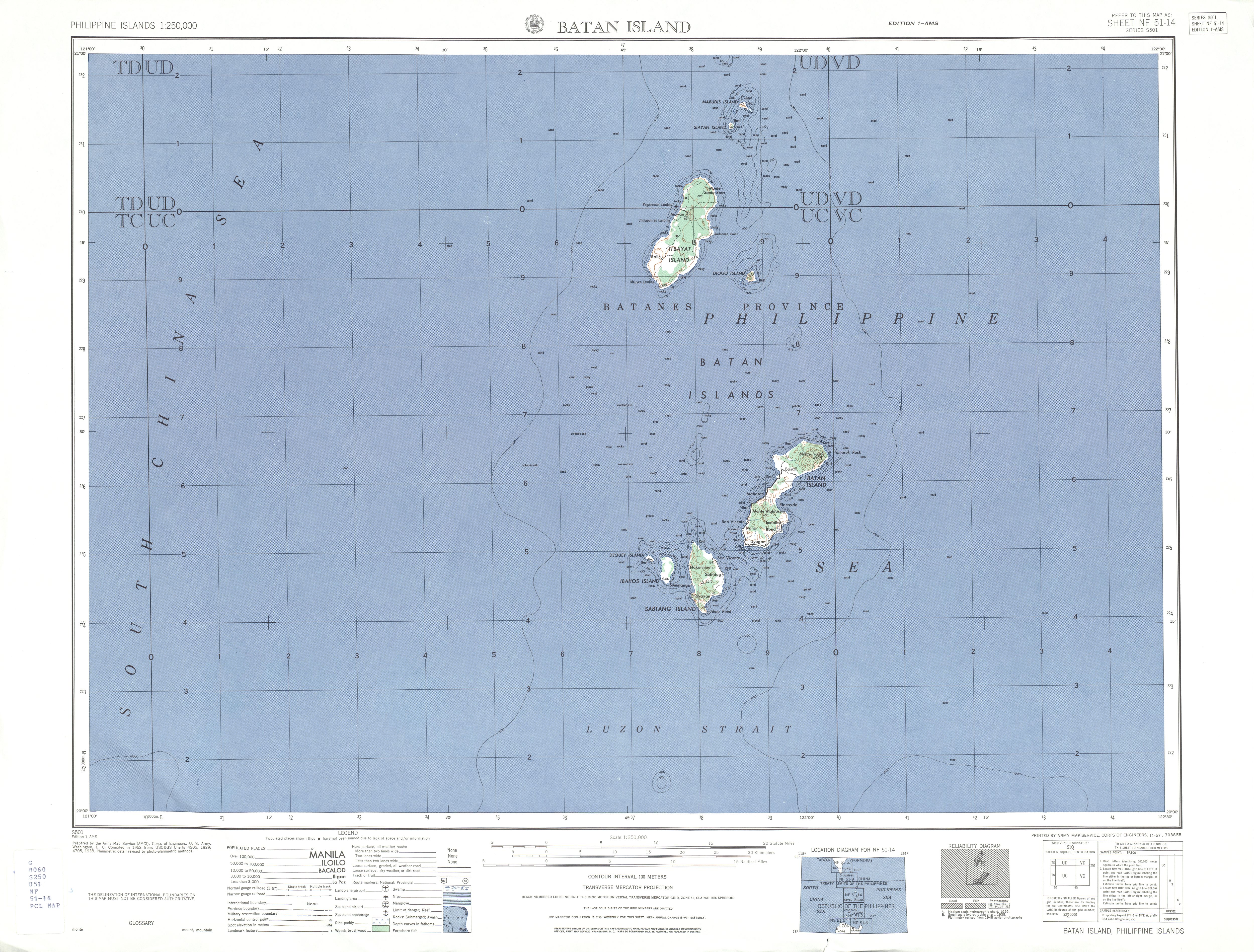
}} Siayan ist eine Insel in der Provinz Batanes auf den Philippinen. Regional ist die Insel auch unter dem Namen Stayan Island bekannt. Sie gehört zu den Batan-Inseln und liegt etwa 295 km vor der Nordküste der Insel Luzon, in der Luzonstraße. Die Insel hat eine Fläche von circa 0,7 km² und gehört zum Verwaltungsgebiet der Stadtgemeinde Itbayat, und darin zum Barangay Marapuy (Santa Maria).

Siayan ist unbewohnt und hat eine rundlich-ovale Form mit einer Länge von circa 1,1 km und einer Breite von circa 0,7 km. Sie ist ein inzwischen erloschener Vulkan, der circa 165 Meter sich über den Meeresspiegel erhebt<ref>Karte der der Provinz Batanes</ref>. Die Küstenlinie der Insel wird durch einen Wechsel von steilen Felskliffen und weißen Sandstränden gebildet. Der Pflanzenwuchs der Insel besteht aus dichter tropischer Vegetation und wird von Palmendieben, Ameisen und Vögeln besiedelt. Menschliche Siedlungsspuren wurden bei den archäologischen Ausgrabungen von 2002 bis 2004 auf der Insel entdeckt, diese belegen, dass die Insel bis vor 1.300 Jahren bewohnt war.<ref><templatestyles src="Webarchiv/styles.css" />{{#if:20140517122145

      | {{#ifeq: 20140517122145 | *
    | Vorlage:Webarchiv/Wartung/Stern{{#if: Crossing the Luzon Strait: Archaeological Chronology in the Batanes Islands, Philippines and the Regional Sequence of Neolithic Dispersal | {{#invoke:WLink|getEscapedTitle|Crossing the Luzon Strait: Archaeological Chronology in the Batanes Islands, Philippines and the Regional Sequence of Neolithic Dispersal}} | {{#invoke:Webarchiv|getdomain|http://en.nmp.gov.tw/lib/3-3-2/2.025-045.pdf}} }} (Archivversionen)
    | {{#iferror: {{#time: j. F Y|20140517122145}}
         | {{#if:  || }}Vorlage:Webarchiv/Wartung/DatumDer Wert des Parameters {{#if: wayback | wayback | Datum }} muss ein gültiger Zeitstempel der Form YYYYMMDDHHMMSS sein!
         | {{#if: Crossing the Luzon Strait: Archaeological Chronology in the Batanes Islands, Philippines and the Regional Sequence of Neolithic Dispersal | {{#invoke:WLink|getEscapedTitle|Crossing the Luzon Strait: Archaeological Chronology in the Batanes Islands, Philippines and the Regional Sequence of Neolithic Dispersal}} | {{#invoke:Webarchiv|getdomain|http://en.nmp.gov.tw/lib/3-3-2/2.025-045.pdf}} }} {{#ifeq:  | [] | [ | ( }}Memento{{#if: {{#if: 2019-05-13 22:02:04 InternetArchiveBot | 2019-05-13 22:02:04 InternetArchiveBot |  }} |  des Vorlage:Referrer }} vom {{#time: j. F Y|20140517122145}} im Internet Archive{{#if:  | ;  }}{{#ifeq:  | [] | ] | ) }}
      }}
  }}
      | {{#if:
          | {{#iferror: {{#time: j. F Y|{{{webciteID}}}}}
    | {{#switch: {{#invoke:Str|len|{{{webciteID}}}}}
       | 16= {{#if: Crossing the Luzon Strait: Archaeological Chronology in the Batanes Islands, Philippines and the Regional Sequence of Neolithic Dispersal | {{#invoke:WLink|getEscapedTitle|Crossing the Luzon Strait: Archaeological Chronology in the Batanes Islands, Philippines and the Regional Sequence of Neolithic Dispersal}} | {{#invoke:Webarchiv|getdomain|http://en.nmp.gov.tw/lib/3-3-2/2.025-045.pdf}} }} {{#ifeq:  | [] | [ | ( }}Memento{{#if: {{#if: 2019-05-13 22:02:04 InternetArchiveBot | 2019-05-13 22:02:04 InternetArchiveBot |  }} |  des Vorlage:Referrer }} vom {{#time: j. F Y| 19700101000000 + {{#expr: floor {{#expr: {{#invoke:Str|sub|{{{webciteID}}}|1|10}}/86400}} }} days}} auf WebCite{{#if:  | ;  }}{{#ifeq:  | [] | ] | ) }}
       | 9 = {{#if: Crossing the Luzon Strait: Archaeological Chronology in the Batanes Islands, Philippines and the Regional Sequence of Neolithic Dispersal | {{#invoke:WLink|getEscapedTitle|Crossing the Luzon Strait: Archaeological Chronology in the Batanes Islands, Philippines and the Regional Sequence of Neolithic Dispersal}} | {{#invoke:Webarchiv|getdomain|http://en.nmp.gov.tw/lib/3-3-2/2.025-045.pdf}} }} {{#ifeq:  | [] | [ | ( }}Memento{{#if: {{#if: 2019-05-13 22:02:04 InternetArchiveBot | 2019-05-13 22:02:04 InternetArchiveBot |  }} |  des Vorlage:Referrer}} vom {{#time: j. F Y| 19700101000000 + {{#expr: floor {{#expr: {{#invoke:Str|sub|{{#invoke:Expr|base62|{{{webciteID}}}}}|1|10}}/86400}} }} days}} auf WebCite{{#if:  | ;  }}{{#ifeq:  | [] | ] | ) }}
       | #default= Der Wert des Parameters {{#if: webciteID | webciteID | ID }} muss entweder ein Zeitstempel der Form YYYYMMDDHHMMSS oder ein Schüsselwert mit 9 Zeichen oder eine 16-stellige Zahl sein!Vorlage:Webarchiv/Wartung/webcitation{{#if:  || }}
      }}
    | c|{{{webciteID}}}}} {{#if: Crossing the Luzon Strait: Archaeological Chronology in the Batanes Islands, Philippines and the Regional Sequence of Neolithic Dispersal | {{#invoke:WLink|getEscapedTitle|Crossing the Luzon Strait: Archaeological Chronology in the Batanes Islands, Philippines and the Regional Sequence of Neolithic Dispersal}} | {{#invoke:Webarchiv|getdomain|http://en.nmp.gov.tw/lib/3-3-2/2.025-045.pdf}} }} (Memento{{#if: {{#if: 2019-05-13 22:02:04 InternetArchiveBot | 2019-05-13 22:02:04 InternetArchiveBot |  }} |  des Vorlage:Referrer}} vom {{#time: j. F Y|{{{webciteID}}}}} auf WebCite{{#if:  | ;  }}{{#ifeq:  | [] | ] | ) }}
  }}
          | {{#if: 
              | Vorlage:Webarchiv/Today
              | {{#if:
                      | Vorlage:Webarchiv/Generisch
                      | {{#if: Crossing the Luzon Strait: Archaeological Chronology in the Batanes Islands, Philippines and the Regional Sequence of Neolithic Dispersal | {{#invoke:WLink|getEscapedTitle|Crossing the Luzon Strait: Archaeological Chronology in the Batanes Islands, Philippines and the Regional Sequence of Neolithic Dispersal}} | {{#invoke:Webarchiv|getdomain|http://en.nmp.gov.tw/lib/3-3-2/2.025-045.pdf}} }}  
                 }}}}}}}}{{#if:2019-05-13 22:02:04 InternetArchiveBot
    | Vorlage:Webarchiv/archiv-bot
  }}{{#invoke:TemplatePar|check
     |all      = url=
     |opt      = text= wayback= webciteID= archive-is= archive-today= archiv-url= archiv-datum= ()= archiv-bot= format= original=
     |cat      = Wikipedia:Vorlagenfehler/Vorlage:Webarchiv
     |errNS    = 0
     |template = Vorlage:Webarchiv
     |format   = *
     |preview  = 1
  }}{{#ifexpr: {{#if:20140517122145|1|0}}{{#if:|+1}}{{#if:|+1}}{{#if:|+1}}{{#if:|+1}} <> 1
    | {{#if:  || }}Vorlage:Webarchiv/Wartung/Parameter{{#invoke:TemplUtl|failure| Fehler bei Vorlage:Webarchiv: Genau einer der Parameter 'wayback', 'webciteID', 'archive-today', 'archive-is' oder 'archiv-url' muss angegeben werden.|1}}
  }}{{#if: 
    | {{#switch: {{#invoke:Webarchiv|getdomain|{{{archiv-url}}}}}
        | web.archive.org = 
          {{#if:  || }}{{#invoke:TemplUtl|failure| Fehler bei Vorlage:Webarchiv: Im Parameter 'archiv-url' wurde URL von Internet Archive erkannt, bitte Parameter 'wayback' benutzen.|1}} 
        | webcitation.org = 
          {{#if:  || }}{{#invoke:TemplUtl|failure| Fehler bei Vorlage:Webarchiv: Im Parameter 'archiv-url' wurde URL von WebCite erkannt, bitte Parameter 'webciteID' benutzen.|1}} 
        | archive.today |archive.is |archive.ph |archive.fo |archive.li |archive.md |archive.vn = 
          {{#if:  || }}{{#invoke:TemplUtl|failure| Fehler bei Vorlage:Webarchiv: Im Parameter 'archiv-url' wurde URL von archive.today erkannt, bitte Parameter 'archive-today' benutzen.|1}}
      }}{{#if: 
         | {{#iferror: {{#iferror:{{#invoke:Vorlage:FormatDate|Execute}}|}}
             | {{#if:  || }}Vorlage:Webarchiv/Wartung/Parameter{{#invoke:TemplUtl|failure| Fehler bei Vorlage:Webarchiv: Der Wert des Parameter 'archiv-datum' ist ungültig oder hat ein ungültiges Format.|1}}
          |  }} 
         | {{#if:  || }}Vorlage:Webarchiv/Wartung/Parameter{{#invoke:TemplUtl|failure| Fehler bei Vorlage:Webarchiv: Der Pflichtparameter 'archiv-datum' wurde nicht angegeben.|1}}
      }}
    | {{#if: 
         | {{#if:  || }}Vorlage:Webarchiv/Wartung/Parameter{{#invoke:TemplUtl|failure| Fehler bei Vorlage:Webarchiv: Der Parameter 'archiv-datum' ist nur in Verbindung mit 'archiv-url' angebbar.|1}}
      }}
  }}{{#if:{{#invoke:URLutil|isHostPathResource|http://en.nmp.gov.tw/lib/3-3-2/2.025-045.pdf}}
    || {{#if:  || }}
  }}{{#if: Crossing the Luzon Strait: Archaeological Chronology in the Batanes Islands, Philippines and the Regional Sequence of Neolithic Dispersal
    | {{#if: {{#invoke:WLink|isBracketedLink|Crossing the Luzon Strait: Archaeological Chronology in the Batanes Islands, Philippines and the Regional Sequence of Neolithic Dispersal}}
        | {{#if:  || }}
      }}
    | {{#if:  || }}Vorlage:Webarchiv/Wartung/Linktext_fehlt
  }}{{#switch: 
    |addlarchives|addlpages= {{#if:  || }}{{#if: 1 |Vorlage:Webarchiv/Wartung/Parameter}}{{#invoke:TemplUtl|failure| Fehler bei Vorlage:Webarchiv: enWP-Wert im Parameter 'format'.|1}}
  }}{{#ifeq: {{#invoke:Str|find|http://en.nmp.gov.tw/lib/3-3-2/2.025-045.pdf%7Carchiv}} |-1
    || {{#ifeq: {{#invoke:Str|find|{{#invoke:Str|cropleft|http://en.nmp.gov.tw/lib/3-3-2/2.025-045.pdf%7C4}}%7Chttp}} |-1
         || {{#switch: {{#invoke:Webarchiv|getdomain|http://en.nmp.gov.tw/lib/3-3-2/2.025-045.pdf }}
              | abendblatt.de | daserste.ndr.de | inarchive.com | webcitation.org = 
              | #default = {{#if:  || }}{{#if: 1 |Vorlage:Webarchiv/Wartung/URL}}{{#invoke:TemplUtl|failure| Fehler bei Vorlage:Webarchiv: Archiv-URL im Parameter 'url' anstatt URL der Originalquelle. Entferne den vor der Original-URL stehenden Mementobestandteil und setze den Archivierungszeitstempel in den Parameter 'wayback', 'webciteID', 'archive.today' oder 'archive-is' ein, sofern nicht bereits befüllt.|1}}
            }} 
       }}
  }} (PDF; 1,4 MB) Autor:Atholl Anderson Journal of Austronesian Studies  1(2) December 2005</ref>

Nördlich liegt Mabudis Island in circa 4 km, südlich liegt Itbayat Island in 8 km (Nordküste), südöstlich liegt Diogo Island in circa 33 km und Batan Island in circa 76 km Entfernung von der Insel. Die nördlichste Insel der Philippinen Y'Ami Island liegt in 34 km Entfernung.

Siehe auch

Einzelnachweise

<references /> {{safesubst:#ifeq:0|10| {{#switch: Siayan Island |Navigationsleiste|NaviBlock|0=|#default= Vorlage:Templatetransclusioncheck Vorlage:Dokumentation/ruler }}}}Vorlage:Klappleiste/Anfang {{#if:

|

 |

Inselgruppen: Babuyan-Inseln | Batan-Inseln

Inseln: Babuyan | Balintang | Batan | Calayan | Camiguin | Dalupiri | Deqeu | Didicas | Diogo | Fuga | Ibuhos | Itbayat | Mabudis | Maysanga | North Island | Palaui | Sabtang | Siayan | Y'Ami }} Vorlage:Klappleiste/Ende