Liste geographischer Mittelpunkte
Es gibt unterschiedliche Berechnungsmethoden zur Ermittlung des Mittelpunktes eines Landes. Einige sind im Artikel Mittelpunkt Deutschlands beschrieben. Es gibt keine wissenschaftliche, von Behörden autorisierte Definition. Die Angabe geographischer Mittelpunkte ist somit eher eine Spielerei. Das lässt viel Raum für unterschiedliche Berechnungen, die zum Teil bemerkenswert voneinander abweichen. Oft haben sie eine touristische Bedeutung, weil kleine Orte aus ihrer Anonymität hervortreten und dem Mittelpunkt ein Denkmal setzen können.
Neben diesen geographischen Verfahren gibt es noch den
- Bevölkerungsmittelpunkt, als den Punkt, zu dem alle Einwohner eines Gebietes durchschnittlich die kürzeste Entfernung (Luftlinie) haben.
- Verkehrsmittelpunkt mit der durchschnittlich kürzesten Anreisestrecke über öffentliche Verkehrsflächen von allen Punkten des Landes, in Abwandlung die Strecke von allen Grenzorten.
- politischen, kulturellen, ökonomischen und/oder gesellschaftlichen Mittelpunkt, der sich selten mit dem Landesmittelpunkt deckt.
Solche Berechnungen können durchaus einen Sinn bei der Planung der Infrastruktur oder Logistik bringen.
Besonders umstritten ist die Mittelpunktberechnung bei Staaten mit diversen getrennten und entfernten Landesteilen, wie z. B. USA (Alaska, Hawaii), Griechenland oder Indonesien (Inselwelt), Exklaven und Enklaven wie bei Russland (Kaliningrad in Polen/Litauen) oder Vereinigtes Königreich/Spanien (Gibraltar), Überseegebiete bzw. entfernte Inseln (Grönland, Kanaren, Azoren, Südgeorgien.)
Diese Liste soll auf die Erde, Kontinente, große geographische Einheiten (z. B. Iberische Halbinsel), Staatengemeinschaften (z. B. EU), Staaten und deren erste Ebene darunter (Bundesländer und Äquivalentes, z. B. Latium, England) begrenzt werden.
Europa heute
| Mittelpunkt von | Gebiet | Ort | Koordinaten | Hinweise | Bild | |||||||||||||
|---|---|---|---|---|---|---|---|---|---|---|---|---|---|---|---|---|---|---|
| Europa (Kontinent) | Datei:Flag of Lithuania.svg Litauen, Datei:Vilnius district COA.svg Rajongemeinde Vilnius | bei Purnuškės | 54° 54′ 0″ N, 25° 19′ 0″ O
{{#coordinates:54,9|25,316666666667|
|
dim=3000 | globe= | name=Mittelpunkt Europas | region=LT-VL | type=landmark
}} || Mittelpunkt Europas Schwerpunkt||Datei:Lithuania Centre of Europe.jpg | ||||||||||
| Datei:Flag of Europe.svg Europäische Union | Datei:Flag of Germany.svg Deutschland, Datei:Flag of Bavaria (lozengy).svg Bayern | Oberwestern bis 31. Januar 2020 |
50° 6′ 48″ N, 9° 15′ 14″ O
{{#coordinates:50,113211111111|9,2539583333333|
|
dim=3000 | globe= | name=Mittelpunkt der EU 2014-2019 | region=DE-BY | type=landmark
}} ||<ref group="Anmerkung">Schwerpunkt, ohne Berücksichtigung von Überseeterritorien (wie Französische Überseegebiete), die nicht Teil des Gebiets der Europäischen Union sind. Die zum Gebiet der Europäischen Union gehörenden französischen Départements et régions d’outre-mer (DOM-ROM) sind bei der Bestimmung jedoch berücksichtigt worden.</ref><ref>Kurzer Ruhm, Tagesspiegel vom 30. Dezember 2016</ref>|| Datei:Mittelpunkt Europas vor Brexit Juni 2017 - 3.jpg | ||||||||||
| Gadheim ab 1. Februar 2020 |
49° 50′ 35″ N, 9° 54′ 7″ O
{{#coordinates:49,843056|9,901944|
|
dim=3000 | globe= | name=Mittelpunkt der EU 2019 | region=DE-BY | type=landmark
}} || <ref group="Anmerkung">Nach dem Austritt des Vereinigten Königreichs aus der EU (Brexit) am 31. Januar 2020 verschob sich der Mittelpunkt um knapp 56 Kilometer nach Südosten. Beim neuen Mittelpunkt wurde eine entsprechende Stelle angelegt.
| ||||||||||||
| Europäische Staaten und Regionen | ||||||||||||||||||
| Datei:Flag of Albania.svg Albanien | Mittelalbanien | Elbasan | 41° 6′ 45″ N, 20° 5′ 6″ O
{{#coordinates:41,112496|20,085011|
|
dim= | globe= | name=Mittelpunkt Albaniens | region=AL-03 | type=landmark }}|| || | ||||||||||
| Datei:Flag of Andorra.svg Andorra | Encamp | 42° 33′ 0″ N, 1° 34′ 0″ O
{{#coordinates:42,55|1,5667|
|
dim=3000 | globe= | name=Mittelpunkt Andorras | region=AD-03 | type=landmark }}||<ref group="Anmerkung">Im Nordwesten der Gemeinde Encamp</ref>|| | |||||||||||
| Baltikum | Lettland, Semgallen | Lejasmisiņi, Tīnūžu pagasts, Bezirk Ikšķile | 56° 51′ 34″ N, 24° 35′ 53″ O
{{#coordinates:56,859333|24,597944|
|
dim=3000 | globe= | name=Mittelpunkt Baltikum | region=LV-067 | type=landmark
}}||<ref group="Anmerkung">Das Zentrum des Baltikums befindet sich in der Gemeinde Ikšķile etwa 2,3 km westlich des Dorfes Tīnūžu. Auf der Wiese werden derzeit Privathäuser gebaut. Die nächstgelegenen Häuser liegen bei Lejas Paegļi, etwa 120 m nordöstlich. Interessanterweise liegt der Baltische Mittelpunkt nur 2,4 km südlich des geographischen Zentrums von Lettland.
|
||||||||||
| Datei:Flag of Belarus.svg Belarus | Puchavičy Rajon, Oblast Minsk | Südöstlich Antonovo ({{Modul:Vorlage:lang}} Modul:Vorlage:lang:103: attempt to index field 'wikibase' (a nil value)) | 53° 31′ 44″ N, 28° 2′ 42″ O
{{#coordinates:53,529003|28,045072|
|
dim=3000 | globe= | name=Mittelpunkt Weißrusslands | region=BY-MI | type=landmark
}} |||| Datei:Zentrum Weißrussland.jpg
| ||||||||||
| Datei:Flag of Belgium (civil).svg Belgien | Wallonisch-Brabant | Walhain Ortsteil Nil-Saint-Vincent-Saint-Martin |
50° 38′ 25″ N, 4° 40′ 0″ O
{{#coordinates:50,640165|4,666715|
|
dim=3000 | globe= | name=Mittelpunkt Belgiens | region=BE-WBR | type=landmark
}} ||<ref group="Anmerkung">Um den Mittelpunkt zu markieren, wurde ein von dem ortsansässigen Architekten Bernard Defrenne entworfenes Monument ca. 239 m nördlich des Place du Tram (Fußgängerzone, ehemalige Bahnnaltestelle) aufgestellt. Es steht auf einem Sockel, der die Erdkruste darstellen soll und in den 12 Lampen eingelassen sind, welche für die zwölf EG-Staaten (EG-12: bis einschließlich 1994, nicht EU) stehen. Drei Säulen, die die drei Regionen Belgiens symbolisieren, tragen eine Pyramide, in deren Mitte eine Stahlrohr befestigt ist, das den Mittelpunkt Belgiens anzeigt. Davor informieren drei Tafeln auf Deutsch, Französisch und Niederländisch über die Bedeutung der Einzelteile des Denkmals. Die Einweihung fand am 22. August 1998 statt – merkwürdig, zu dem Zeitpunkt gab es schon die EU-15: bis einschließlich April 2004.</ref> || Datei:CentreOfBelgium.jpg | ||||||||||
| Datei:Flag of Bosnia and Herzegovina.svg Bosnien und Herzegowina | Zentralbosnien | Travnik | 44° 12′ 36″ N, 17° 47′ 42″ O
{{#coordinates:44,21|17,795|
|
dim=3000 | globe= | name=Mittelpunkt Bosnien und Herzegowina | region=BA-BIH | type=landmark }} || <ref group="Anmerkung">zwischen Travnik und Zenica</ref>|| | ||||||||||
| Datei:Flag of Bulgaria.svg Bulgarien | Oblastgrenze Gabrowo/Stara Sagora | Usana | 42° 45′ 58″ N, 25° 14′ 18″ O
{{#coordinates:42,76611|25,23844|
|
dim=3000 | globe= | name=Mittelpunkt Bulgariens | region=BG-07/BG-24 | type=landmark
}} || || Datei:Uzana Iz1.jpg
| ||||||||||
| Datei:Flag of Denmark.svg Dänemark | Region Sjælland ({{Modul:Vorlage:lang}} Modul:Vorlage:lang:103: attempt to index field 'wikibase' (a nil value)) | Rørvig | 55° 57′ 34″ N, 11° 45′ 52″ O
{{#coordinates:55,959461|11,764404|
|
dim=1000 | globe= | name=Mittelpunkt Dänemarks | region=DK-85 | type=landmark
}} || <ref group="Anmerkung">Dänemark hat mehrere Mittelpunkte, denn die Inseln, ggf. einschließlich Grönlands, lassen mehrere Berechnungen zu. Der offizielle Mittelpunkt berücksichtigt auch die Insel Bornholm. | ||||||||||
| Region Midtjylland ({{Modul:Vorlage:lang}} Modul:Vorlage:lang:103: attempt to index field 'wikibase' (a nil value)) | Odder | 55° 58′ 42″ N, 10° 9′ 38″ O
{{#coordinates:55,978467|10,160653|
|
dim=1000 | globe= | name=Mittelpunkt Dänemarks | region=DK-82 | type=landmark }} || <ref group="Anmerkung">Unscheinbarer Stein am Fuß eines Baumes ggü. Nølevvej 5</ref>|| | |||||||||||
| Datei:Flag of Germany.svg Deutschland | Unstrut-Hainich-Kreis, Thüringen | Niederdorla | 51° 8′ 0″ N, 10° 25′ 0″ O
{{#coordinates:51,133333333333|10,416666666667|
|
dim=3000 | globe= | name=Schwerpunkt Deutschlands | region=DE-TH | type=landmark
}} || geografischer Mittelpunkt |
Datei:Mittelpunktstein Niederdorla.JPG | |||||||||
| Datei:Flag of Estonia.svg Estland | Kreis Jõgeva | Adavere ({{Modul:Vorlage:lang}} Modul:Vorlage:lang:103: attempt to index field 'wikibase' (a nil value)), Kalmemägi, Kalme | 58° 41′ 39″ N, 25° 54′ 28″ O
{{#coordinates:58,694224|25,907678|
|
dim=3000 | globe= | name=Mittelpunkt Estlands | region=EE-50 | type=landmark
}} || <ref>Mandri-Eesti keskpunkt</ref>||Datei:Mandri-Eesti keskpunkt Adavere1.jpg | ||||||||||
| Datei:Flag of Finland icon.svg Finnland | Nordösterbotten | Piippola | 64° 10′ 47″ N, 25° 48′ 9″ O
{{#coordinates:64,179674|25,802478|
|
dim=3000 | globe= | name=Mittelpunkt Finnlands | region=FI-14 | type=landmark
}}|| ||Datei:Centerpoint of Finland - panoramio.jpg
| ||||||||||
| Datei:Flag of France.svg Frankreich | La Brande du Murat, Département Allier | Nassigny | 46° 29′ 38″ N, 2° 36′ 10″ O
{{#coordinates:46,49388889|2,60277778|
|
dim=3000 | globe= | name=Mittelpunkt französisches Mutterland (mit Korsika) | region=FR-03 | type=landmark
}}||Mit Berücksichtigung von Datei:Flag of Corsica.svg Korsika|| | ||||||||||
| La Coucière, Département Cher | Vesdun | 46° 32′ 23″ N, 2° 25′ 49″ O
{{#coordinates:46,539722222222|2,4302777777778|
|
dim=3000 | globe= | name=Mittelpunkt französisches Mutterland (ohne Korsika) | region=FR-18 | type=landmark }}|| ohne Berücksichtigung von Korsika|| | |||||||||||
| Datei:Flag of Greece.svg Griechenland | Mittelgriechenland | Delphi | 38° 28′ 53″ N, 22° 30′ 0″ O
{{#coordinates:38,4813|22,5|
|
dim=3000 | globe= | name=Historischer Mittelpunkt Griechenlands | region=GR-H | type=landmark
}}
{{#coordinates:38,27485|24,50945|
|
dim=45000 | globe= | name=Berechneter Mittelpunkt Griechenlands | region=GR-H | type=landmark
}} in der Ägäis etwa 20 km östlich des Almirimi-Strandes {{#coordinates:38,26134|24,2517| |
dim=1000 | globe= | name=Almirimi-Strand | region=GR-H | type=landmark
}} auf Südeuböa liegen.
|
| Datei:Flag of the United Kingdom.svg Großbritannien (Insel) |
Forest of Bowland, Lancashire | Wolfhole Crag | 54° 0′ 13″ N, 2° 32′ 52″ W
{{#coordinates:54,00366|−2,547855|
|
dim=3000 | globe= | name=Mittelpunkt GB einschließlich Inseln | region=GB-LAN | type=landmark
}}|| siehe auch Vereinigtes KönigreichSkriptfehler: Ein solches Modul „Vorlage:Anker“ ist nicht vorhanden. | ||||||||||
| Brennand Farm | 54° 0′ 13″ N, 2° 32′ 52″ W
{{#coordinates:54,00366|−2,547855|
|
dim=3000 | globe= | name=Mittelpunkt GB incl. Inseln | region=GB-LAN | type=landmark }} || Berechnung durch Ordnance Survey unter Einschluss aller Inseln.<ref group="Anmerkung">Etwa sieben Kilometer nordwestlich von Dunsop Bridge. An dem genauen Punkt gibt es kein Denkmal oder Schild. Es ist nur ein unbestimmtes Grasbüschel, umgeben von Torfmoor. In der Nähe wurde die 100.000. Telefonzelle der BT eingerichtet mit dem Hinweis: “You are calling from the BT payphone that marks the centre of Great Britain”. – Stuck in the middle with ewe</ref>|| | ||||||||||||
| Lancashire | Whalley, OS Grid Reference SD7232136671 | 53° 49′ 32″ N, 2° 25′ 19″ W
{{#coordinates:53,825564|−2,421976|
|
dim=3000 | globe= | name=Mittelpunkt GB ohne Inseln | region=GB-LAN | type=landmark }} || Berechnung durch Ordnance Survey unter Ausschluss der Inseln || | |||||||||||
| Iberische Halbinsel | Provinz Madrid | Getafe, Cerro de Los Ángeles | 40° 18′ 30″ N, 3° 41′ 5″ W
{{#coordinates:40,308405|−3,684701|
|
dim=3000 | globe= | name=Mittelpunkt Iberische Halbinsel | region=ES-M | type=landmark
}} || || Datei:Cerro de los Ángeles (Getafe) - panoramio.jpg
| ||||||||||
| Datei:Flag of Ireland.svg Irland | County Galway, Connacht | Carrownafinnoge | 53° 10′ 50″ N, 8° 9′ 48″ W
{{#coordinates:53,180671|−8,163331|
|
dim=3000 | globe= | name=Mittelpunkt Republik Irland | region=IE-G | type=landmark }} ||<ref name="IE">Geographical Facts and Figures</ref>|| | ||||||||||
| Irland (Insel) | County Roscommon | Carnagh East ({{Modul:Vorlage:lang}} Modul:Vorlage:lang:103: attempt to index field 'wikibase' (a nil value) | 53° 30′ 0″ N, 8° 0′ 0″ W
{{#coordinates:53,5|−8|
|
dim=3000 | globe= | name=Mittelpunkt Irlands (Insel) | region=IE-RN | type=landmark
}} ||<ref name="IE" />||Datei:Pasture at Carnagh East - geograph.org.uk - 964628.jpg
| ||||||||||
| Datei:Flag of Iceland.svg Island | Hofsjökull-Gletscher | 64° 59′ 1,3″ N, 18° 27′ 26,1″ W
{{#coordinates:64,9836934|−18,4572505|
|
dim=100 | globe= | name=Mittelpunkt Islands | region=IS-5 | type=landmark
}} || Etwas nordöstlich des Hofsjökull-Gletschers |
dim=300 | globe= | name=Kolbeinsey | region=IS | type=landmark
}}. Es ist nur ein 0,009 ha großer Felsen im Meer, den Island jedoch auch gegen Naturgewalten verteidigt, um das Hoheitsgebiet zu wahren, z. B. wegen der Fischereirechte. | ||||||
| Datei:Flag of Italy.svg Italien | Latium | Rieti | 42° 24′ 8″ N, 12° 51′ 44″ O
{{#coordinates:42,402322|12,862094|
|
dim=3000 | globe= | name=Mittelpunkt Italiens | region=IT-62 | type=landmark }} ||||<templatestyles src="Vorlage:Galerie/styles.css" /> | ||||||||||
| Umbrien | südwestlich von Narni | 42° 30′ 27″ N, 12° 32′ 17″ O
{{#coordinates:42,507383|12,538017|
|
dim=3000 | globe= | name=Mittelpunkt Italiens 1994 | region=IT-55 | type=landmark
}} || <ref group="Anmerkung">Die Berechnungen von 1994 haben Ponte Cardona an den genannten Koordinaten als „L’ombelicolo d’Italia“ ergeben. | |||||||||||
| Datei:Flag of Kazakhstan.svg Kasachstan europäischer Teil |
Westkasachstan | nahe einem See, nordwestlich von Schangaqasan im Audan Schangaqala | 49° 3′ 2,1″ N, 49° 31′ 42,6″ O
{{#coordinates:49,05059|49,5285|
|
dim= | globe= | name=Mittelpunkt Europäisch-Kasachstans | region=KZ-27 | type=landmark
}} |
<ref group="Anmerkung">Europäischer Teil (5,4 %). Das Zentrum liegt vermutlich etwas nördlich von Novaya Kazanka</ref> | |||||||||
| Datei:Flag of Kosovo.svg Kosovo | Gemeinde Drenas | Fushticë e Ulët | 42° 33′ 20″ N, 20° 54′ 46″ O
{{#coordinates:42,555556|20,912778|
|
dim=3000 | globe= | name=Geschätzter Mittelpunkt des Kosovo | region=RS-KM | type=landmark
}} ||<ref>Gjeografia, KPMM komisioni i pavarur për miniera dhe minerale, Kosovo (Seite nicht mehr abrufbar, festgestellt im März 2022. Suche im Internet Archive )Vorlage:Toter Link/archivebot</ref> |
||||||||||
| Datei:Flag of Croatia.svg Kroatien | Bosnien und Herzegowina | Dorf Drinić (nahe einem Restaurant), Verbandsgemeinde Petrovac, Republika Srpska, Bosnien und Herzegowina;
27 Kilometer von der kroatischen Grenze entfernt |
44° 29′ N, 16° 29′ O
{{#coordinates:44,487805555556|16,491194444444|
|
dim=3000 | globe= | name=Geschätzter Mittelpunkt Kroatiens | region=BA-SRP | type=landmark
}}||<ref group="Anmerkung">Der Mittelpunkt der Fläche liegt gut 20 km entfernt im südlichen Ausland. Daher wird oft Zagreb oder an der Küste Biograd na Moru als Landeszentrum angegeben.
|
||||||||||
| Datei:Flag of Latvia.svg Lettland | Lejaskraučas, Tīnūžu pagasts, Bezirk Ikšķile, Vidzeme | Tīnūži/Ikskile | 56° 52′ 49″ N, 24° 36′ 22″ O
{{#coordinates:56,880138888889|24,606222222222|
|
dim=3000 | globe= | name=Mittelpunkt Lettlands | region=LV-067 | type=landmark
}} || Mittelpunkt<ref group="Anmerkung">Der geografische Mittelpunkt Lettlands liegt in der Gemeinde Ikšķile etwa 3,3 km nordöstlich des Dorfes Tīnūži. Er befindet sich auf einer Wiese, die derzeit ein Baugelände für Privathäuser ist. Das nächstgelegenen Haus des Weilers Auriņi liegt 60 m südöstlich. Der Mittelpunkt ist nicht gekennzeichnet. Das Interessante ist, dass sich das geographische Zentrum des Baltikums nur ca. 2,4 km südlich befindet. |
||||||||||
| Suntažu pagasts, Bezirk Ogre, Semgallen | zwischen Varži und Viršņukalns | 56° 52′ 51″ N, 24° 59′ 2″ O
{{#coordinates:56,880889|24,983861|
|
dim=3000 | globe= | name=Schwerpunkt Lettlands | region=LV-067 | type=landmark
}} || Schwerpunkt<ref group="Anmerkung">Die Berechnungen von „NeoGeo“ zeigen, dass sich der Schwerpunkt Lettlands in der Gemeinde Sintiu des Landkreises Ogre befindet. Er liegt etwa 4,3 km südöstlich des Dorfes Samos in der Gemeinde Viršņukalns. Das geographische Zentrum Lettlands liegt 23 km westlich des Schwerpunkts Lettlands |
|||||||||||
| Datei:Flag of Liechtenstein.svg Liechtenstein | Gaflei, Gemeinde Triesenberg | auf der Alp Bargälla | 47° 8′ 30″ N, 9° 33′ 11″ O (760379 / 223343)
{{#coordinates:47,14162|9,55315|
|
dim=3000 | globe= | name=Mittelpunkt Liechtensteins | region=LI-10 | type=landmark
}}|||| Datei:Zentrum Fürstentum Liechtenstein.jpg
| ||||||||||
| Datei:Flag of Lithuania.svg Litauen | Ruoščiai | etwa 3 km südlich von Dotnuva ({{Modul:Vorlage:lang}} Modul:Vorlage:lang:103: attempt to index field 'wikibase' (a nil value))<ref>Vorlage:Cite book/Name: [Internetquelle: archiv-url ungültig Lietuvos geografiniai ekstremumai.] Nacionalinė žemės tarnyba prie ŽŪM, , archiviert vom Vorlage:IconExternal (nicht mehr online verfügbar) am Vorlage:Cite book/URL (Lua-Fehler in Modul:Multilingual, Zeile 153: attempt to index field 'data' (a nil value)).Vorlage:Cite book/URLVorlage:Cite book/MeldungVorlage:Cite book/Meldung2Vorlage:Cite book/MeldungVorlage:Cite book/MeldungVorlage:Cite book/MeldungVorlage:Cite book/MeldungVorlage:Cite book/Meldung</ref> | 55° 19′ 48″ N, 23° 54′ 20″ O
{{#coordinates:55,33|23,905555555556|
|
dim=3000 | globe= | name=Mittelpunkt Litauens | region=LT-18 | type=landmark
}} ||Nach Berechnung von 1995 |
Datei:Ruoščiai004.JPG | |||||||||
| Datei:Flag of Luxembourg.svg Luxemburg | Kanton Mersch | Mersch, Naturschutzgebiet Pëttenerbësch | 49° 46′ 38″ N, 6° 5′ 43″ O
{{#coordinates:49,777222|6,095278|
|
dim=3000 | globe= | name=Mittelpunkt Luxemburgs | region=LU-ME | type=landmark
}} || Berechnung von 2009 Geographisches Zentrum von Luxemburg ||Datei:Luxembourg Centre géographique 2014 a.jpg | ||||||||||
| Datei:Flag of Malta.svg Malta | Nordwest-Malta, Western | Ħal Lija | 35° 53′ 49″ N, 14° 26′ 16″ O
{{#coordinates:35,897078|14,437648|
|
dim=3000 | globe= | name=Mittelpunkt Maltas | region=MT-24 | type=landmark
}}|| <ref group="Anmerkung">Il-Knisja tal-Madonna tal-Mirakli ({{Modul:Vorlage:lang}} Modul:Vorlage:lang:103: attempt to index field 'wikibase' (a nil value))
|
||||||||||
| Datei:Flag of the Netherlands.svg Niederlande | Gelderland | Lunteren | 52° 6′ 3″ N, 5° 38′ 46″ O
{{#coordinates:52,10095|5,646217|
|
dim=3000 | globe= | name=Mittelpunkt der Niederlande | region=NL-GE | type=landmark
}} || Geografischer Mittelpunkt||Datei:Lunteren middelpunt.jpg
| ||||||||||
| Putten | 52° 14′ 36″ N, 5° 38′ 3″ O
{{#coordinates:52,243323|5,634135|
|
dim=3000 | globe= | name=Schwerpunkt der Niederlande | region=NL-GE | type=landmark
}} || Geometrischer Schwerpunkt|| Datei:Putten zwaartepunt.jpg | ||||||||||||
| Datei:Flag of North Macedonia.svg Nordmazedonien | Vardar | Veles | 41° 43′ 12″ N, 21° 47′ 36″ O
{{#coordinates:41,72|21,793333|
|
dim=3000 | globe= | name=Mittelpunkt Nordmazedonien | region=MK-101 | type=landmark }}|||| | ||||||||||
| Datei:Flag of Norway.svg Norwegen | Steinkjer in Trøndelag | Ogndalsfjella <ref group="Anmerkung">Bei der üblichen Berechnung würde sich als Zentrum ein Punkt in Schweden ergeben</ref> |
63° 59′ 26″ N, 12° 18′ 28″ O
{{#coordinates:63,990556|12,307778|
|
dim=3000 | globe= | name=Mittelpunkt Norwegens | region=NO-50 | type=landmark
}} ||||Datei:Norges geografiske midtpunkt vinterstid.jpg
| ||||||||||
| Datei:Flag of Austria.svg Österreich | Bezirk Liezen, Steiermark | Stainach-Pürgg | 47° 35′ 38″ N, 14° 7′ 28″ O
{{#coordinates:47,59397|14,12456|
|
dim=3000 | globe= | name=Mittelpunkt Österreichs | region=AT-6 | type=landmark
}} || |
Datei:Bärenfeuchtmölbing 1.jpg | |||||||||
| Datei:Flag of Poland.svg Polen | Woiwodschaft Łódź | Piątek | 52° 4′ 9″ N, 19° 28′ 50″ O
{{#coordinates:52,069167|19,480556|
|
dim=3000 | globe= | name=Mittelpunkt Polens | region=PL-10 | type=landmark
}} || <ref>polen.Der geometrische Mittelpunkt Polens in Piątek. 27. April 2016, abgerufen am 11. Juni 2021.</ref> ||Datei:Poland Piatek - center of country.jpg | ||||||||||
| Datei:Flag of Portugal.svg Portugal | Centro, Pinhal Interior Sul | Vila de Rei/Piço da Melriça | 39° 41′ 40″ N, 8° 7′ 50″ W
{{#coordinates:39,694502|−8,130573|
|
dim=3000 | globe= | name=Mittelpunkt Portugals | region=PT-05 | type=landmark
}}||<ref>Pico da Melriça: Aqui é o centro de Portugal?</ref>||Datei:Centro geodésico Portugal.JPG | ||||||||||
| Datei:Flag of Romania.svg Rumänien | Gemeinde Merghindeal, Kreis Sibiu (Siebenbürgen) | Schönberg ({{Modul:Vorlage:lang}} Modul:Vorlage:lang:103: attempt to index field 'wikibase' (a nil value))<ref group="Anmerkung">Nahe der Ortseinfahrt aus Richtung Agnita befindet sich der geografische Mittelpunkt Rumäniens (in den Grenzen seit 1945)</ref> | 45° 59′ 8″ N, 24° 41′ 9″ O
{{#coordinates:45,985621|24,685841|
|
dim=3000 | globe= | name=Mittelpunkt Rumäniens | region=RO-SB | type=landmark
}}|| |
<templatestyles src="Vorlage:Galerie/styles.css" /> | |||||||||
| Datei:Flag of Russia.svg Russland europäischer Teil |
Nischni Nowgorod | südlich Timoshino ({{Modul:Vorlage:lang}} Modul:Vorlage:lang:103: attempt to index field 'wikibase' (a nil value)) | geschätzt: 57° 31′ 0″ N, 44° 24′ 0″ O {{#coordinates:57,5167|44,4|
|
dim=3000 | globe= | name=Mittelpunkt europäisches Russland | region=RU-NIZ | type=landmark
}} ||<ref group="Anmerkung">Europäischer Teil Russlands: 23,16 %; ohne annektierte Krim. Da die Grenze zu Asien unterschiedlich definiert wird, ist ein genaues Zentrum nur zu schätzen.</ref>|| | ||||||||||
| Datei:Flag of San Marino.svg San Marino | Borgo Maggiore | Monte Titano | 43° 56′ 13″ N, 12° 27′ 4″ O
{{#coordinates:43,93704|12,45114|
|
dim=3000 | globe= | name=Mittelpunkt San Marino | region=SM-06 | type=landmark }} || Nordöstlich von Monte Titano|| | ||||||||||
| Datei:Flag of Sweden.svg Schweden | Torpshammar, Medelpad | Flataklocken Schwedens Mittelpunkt | 62° 23′ 12″ N, 16° 19′ 16″ O
{{#coordinates:62,38671|16,32122|
|
dim=3000 | globe= | name=Mittelpunkt Schwedens | region=SE-Y | type=landmark
}}|||| Datei:SverigesGeografiskaMittpunkt.jpg
| ||||||||||
| Datei:Flag of Switzerland within 2to3.svg Schweiz | Kanton Obwalden | Älggi-Alp | 46° 48′ 4″ N, 8° 13′ 36″ O (660158 / 183640)
{{#coordinates:46,801210194444|8,2266921944444|
|
dim=3000 | globe= | name=Flächenschwerpunkt der Schweiz | region=CH-OW | type=landmark
}} |
dim=3000 | globe= | name=Symbolischer Mittelpunkt der Schweiz | region=CH-OW | type=landmark
}} ]||Schwerpunkt [ Markierte Stelle ]|| Datei:Geografischer Mittelpunkt der Schweiz.JPG | |||||
| Kanton Bern | Silbermoos in Uetendorf | 46° 47′ 0″ N, 7° 34′ 0″ O (609778 / 181368)
{{#coordinates:46,783408|7,56668|
|
dim=3000 | globe= | name=Grenzfernster Ort der Schweiz | region=CH-BE | type=landmark }} || Landesmittelpunkt (Grenzfernster Ort)|| | |||||||||||
| Datei:Flag of Slovakia.svg Slowakei | Mittelslowakei | am Berg Majerový Hrb | 48° 43′ 23″ N, 19° 14′ 35″ O
{{#coordinates:48,72311|19,243098|
|
dim=3000 | globe= | name=Mittelpunkt Slowakei | region=SK-BC | type=landmark
}} || |
||||||||||
| Datei:Flag of Slovenia.svg Slowenien | Litija ({{Modul:Vorlage:lang}} Modul:Vorlage:lang:103: attempt to index field 'wikibase' (a nil value)), Region Dolenjska ({{Modul:Vorlage:lang}} Modul:Vorlage:lang:103: attempt to index field 'wikibase' (a nil value)) | Spodnja Slivna | 46° 7′ 12″ N, 14° 48′ 55″ O
{{#coordinates:46,119944|14,815333|
|
dim=3000 | globe= | name=Mittelpunkt Sloweniens | region=SI-060 | type=landmark
}}|||| Datei:GEOSS Vače - panoramio.jpg
| ||||||||||
| Datei:Flag of Spain.svg Spanien | Madrid | Kilometer Zero, Plaza Puerta del Sol | 40° 25′ 1″ N, 3° 42′ 13″ W
{{#coordinates:40,4169|−3,7036|
|
dim=3000 | globe= | name=Mittelpunkt Spaniens | region=ES-MD | type=landmark
}}||||Datei:MadridPuertaDelSol Km0.jpg
| ||||||||||
| Datei:Flag of the Czech Republic.svg Tschechien | Kraj Vysočina | Číhošť | 49° 44′ 37″ N, 15° 20′ 19″ O
{{#coordinates:49,743611111111|15,338611111111|
|
dim=3000 | globe= | name=Mittelpunkt Tschechiens | region=CZ-63 | type=landmark
}} |||| Datei:Geografický střed České republiky.jpg
| ||||||||||
| Böhmen | Ďábel | 49° 53′ 29″ N, 14° 25′ 58″ O
{{#coordinates:49,89127|14,4327517|
|
dim=3000 | globe= | name=Mittelpunkt Böhmens | region=CZ-20 | type=landmark }} || Ursprung des kleinsten einschließenden Radiuses|| | |||||||||||
| Mähren | Předina | 49° 23′ 8″ N, 17° 7′ 22″ O
{{#coordinates:49,3855322|17,1228456|
|
dim=3000 | globe= | name=Mittelpunkt Mährens | region=CZ-71 | type=landmark
}} || |
|||||||||||
| Datei:Flag of Turkey.svg Türkei europäischer Teil |
Ostthrakien | Muratlı/Tekirdağ | geschätzt: 41° 4′ 25″ N, 27° 34′ 31,6″ O {{#coordinates:41,07362|27,5754495|
|
dim= | globe= | name=Mittelpunkt europäische Türkei | region=TR-59 | type=landmark
}} |
||||||||||
| Datei:Flag of Ukraine.svg Ukraine | Oblast Kirowohrad | bei Dobrowelytschkiwka | 48° 24′ 1″ N, 31° 9′ 25″ O
{{#coordinates:48,400393|31,1568663|
|
dim=3000 | globe= | name=Mittelpunkt der Ukraine | region=UA-35 | type=landmark
}}|| <ref group="Anmerkung">Inklusive Krim |
||||||||||
| Datei:Flag of Hungary.svg Ungarn | Komitat Pest | Pusztavacs | 47° 10′ 48″ N, 19° 30′ 14″ O
{{#coordinates:47,1801|19,50399|
|
dim=3000 | globe= | name=Mittelpunkt Ungarns | region=HU-PE | type=landmark
}} || |
<templatestyles src="Vorlage:Galerie/styles.css" /> | |||||||||
| Datei:Flag of Vatican City (2023–present).svg Vatikanstadt | in den Vatikanischen Gärten, bei einer Straßenkreuzung nahe der Fontana dell'Aquilone | 41° 54′ 13,8″ N, 12° 27′ 7,4″ O
{{#coordinates:41,90382|12,45205|
|
dim= | globe= | name=Mittelpunkt Vatikan | region=VA | type=landmark
}}|| |
|||||||||||
| Datei:Flag of the United Kingdom.svg Vereinigtes KönigreichSkriptfehler: Ein solches Modul „Vorlage:Anker“ ist nicht vorhanden. | England Datei:Flag of Scotland.svg Datei:Flag of Northern Ireland.svg Datei:Flag of Wales (1959–present).svg Irische See |
westliche Morecambe Bay | 54° 5′ 36″ N, 2° 53′ 41″ W
{{#coordinates:54,093409|−2,89479|
|
dim=3000 | globe= | name=Mittelpunkt UK | region=GB-LAN | type=landmark
}}||siehe auch Großbritannien | ||||||||||
| Datei:Flag of England.svg England | Lindley Hall Farm, 1,5 km östlich von Fenny Drayton und 5 km nördlich von Nuneaton | 52° 34′ 4″ N, 1° 27′ 53″ W
{{#coordinates:52,567906|−1,464667|
|
dim=3000 | globe= | name=Mittelpunkt Englands (Festland) | region=GB-LEC | type=landmark
}}||nur Festland |
|||||||||||
| Zwischen Lindley Hall Farm und Lindley Grange 1,5 km östlich von Fenny Drayton und 5 km nördlich von Nuneaton | 52° 33′ 43″ N, 1° 27′ 54″ W
{{#coordinates:52,561911|−1,464872|
|
dim=3000 | globe= | name=Mittelpunkt Englands incl. Inseln | region=GB-LEC | type=landmark }}||mit Inseln || | ||||||||||||
| Datei:Flag of Scotland.svg Schottland <ref>Centre of Scotland Stone markinh the Centre of Scotland The Geographic Center of Scotland In pictures: The centre of Scotland Brave hearts of Scotland Highland Town Proudly Claims to be the Centre of Scotland (Seite nicht mehr abrufbar, festgestellt im März 2022. Suche im Internet Archive )Vorlage:Toter Link/archivebot Centre of Scotland Stone Dedication</ref> |
schottische Highlands, Hügel Nahe Loch Garry ({{Modul:Vorlage:lang}} Modul:Vorlage:lang:103: attempt to index field 'wikibase' (a nil value)) | 56° 49′ 1″ N, 4° 10′ 58″ W
{{#coordinates:56,816922|−4,18265|
|
dim=3000 | globe= | name=Schwerpunkt Schottlands | region=GB-HLD | type=landmark }} || Schwerpunkt || | |||||||||||
| schottische Highlands, Newtonmore, Glentruim | 57° 1′ 12″ N, 4° 10′ 41″ W
{{#coordinates:57,02|−4,178|
|
dim=3000 | globe= | name=Mittelpunkt Schottlands | region=GB-HLD | type=landmark }} ||Geografischer Mittelpunkt<ref group="Anmerkung">Der Mittelpunkt von Schottland, definiert durch den am weitesten entfernten Punkt zwischen Nordsee und Atlantik, liegt südlich von Newtonmore in Glentruim. Der Punkt wurde früher von der Ordnance Survey durch einen Stein markiert und mit einer Gedenktafel versehen, die gestohlen und nicht ersetzt wurde. Das Clan Macpherson Memorial ist in der Nähe.</ref>|| | ||||||||||||
| Datei:Flag of Northern Ireland.svg Nordirland | Annaghone, bei Cookstown, County Tyrone | 54° 36′ 27″ N, 6° 41′ 35″ W
{{#coordinates:54,607577|−6,693145|
|
dim=3000 | globe= | name=Mittelpunkt Nordirland | region=GB-MUL | type=landmark
}}|| |
|||||||||||
| Datei:Flag of Wales (1959–present).svg Wales | 7,5 km nordwestlich des Stausees Claerwen und 2,5 km südlich von Cwmystwyth | 52° 19′ 49″ N, 3° 45′ 59″ W
{{#coordinates:52,330203|−3,766403|
|
dim=3000 | globe= | name=Mittelpunkt Wales | region=GB-CGN | type=landmark
}} || einschließlich vorgelagerter Inseln |
|||||||||||
| 3,5 km nordwestlich des Stausees Claerwen neben Afon Claerddu | 52° 17′ 43″ N, 3° 44′ 38″ W
{{#coordinates:52,295389|−3,743986|
|
dim=3000 | globe= | name=Mittelpunkt Wales (Festland) | region=GB-CGN | type=landmark
}}||nur Festland |
||||||||||||
.svg)
.svg)
.svg)
_-_panoramio.jpg)
.JPG)
.svg)
Anmerkungen
<references group="Anmerkung" responsive />
Europa historisch
| Mittelpunkt von | Gebiet | Ort | Koordinate | Hinweis | Bild | |||||
|---|---|---|---|---|---|---|---|---|---|---|
| Preußen (1815) | Brandenburg | Dolgelin Gemeinde Lindendorf | geschätzt: 52° 30′ N, 14° 27′ O
{{#coordinates:52,496389|14,446667|
|
dim= | globe= | name=Mittelpunkt Preußen 1815 | region=DE-BB | type=landmark
}} || || Datei:Map-DB-PrussiaProvs-1818.svg
| ||
| Königreich Sachsen (ab 1815) | Sachsen | Lichtenberg/Erzgeb. bei Mulda im Landkreis Mittelsachsen | 50° 49′ N, 13° 27′ O
{{#coordinates:50,816667|13,458333|
|
dim= | globe= | name=Mittelpunkt Königreich Sachsen 1815 | region=DE-BB | type=landmark
}} || Geografischer Mittelpunkt Sachsens<ref group="Anmerkung">Mittelwerte der Koordinaten des nördlichsten und südlichsten sowie des östlichsten und westlichsten Punktes des Landes. Der geografische Mittelpunkt des Königreiches 1992 vom Dresdner Kartografen Hans Brunner ermittelt.</ref>||rowspan=2|Datei:Kurkreis.jpg | ||
| Großschirma bei Freiberg, Landkreis Mittelsachsen | 50° 58′ N, 13° 17′ O
{{#coordinates:50,966389|13,278056|
|
dim= | globe= | name=Schwerpunkt Königreich Sachsen 1815 | region=DE-BB | type=landmark
}} || Physikalischer Schwerpunkt von Sachsen | ||||
| Deutsches Reich (1871–1918) | Brandenburg | Spremberg | 51° 34′ 19,5″ N, 14° 22′ 16,2″ O
{{#coordinates:51,572083333333|14,371166666667|
|
dim= | globe= | name=Mittelpunkt Deutsches Reich | region=DE-BB | type=landmark
}}|| Skriptfehler: Ein solches Modul „Vorlage:Siehe auch“ ist nicht vorhanden. |
Datei:Spremberg Mittelpunkt vom Deutschen Reiche.jpg | |
| Deutsche Demokratische Republik (1949–1990) | Bezirk Potsdam | Verlorenwasser / Weitzgrund | 52° 12′ 0″ N, 12° 31′ 0″ O
{{#coordinates:52,2|12,516666666667|
|
dim= | globe= | name=Mittelpunkt der DDR | region=DE-BB | type=landmark
}} || Skriptfehler: Ein solches Modul „Vorlage:Siehe auch“ ist nicht vorhanden. |
Datei:Mittelpunkt DDR.JPG | |
| Bundesrepublik Deutschland (1957–1990) | Hessen | Rennerod im Westerwald | <ref group="Anmerkung">Der Mittelpunkt liegt im Stadtgebiet und ist weder speziell ausgewiesen noch gekennzeichnet.</ref> | |||||||
| Herbstein (Vogelsbergkreis) | 50° 32′ 18″ N, 9° 21′ 41″ O
{{#coordinates:50,538333333333|9,3613888888889|
|
dim= | globe= | name=Mittelpunkt der BRD bis 03.10.99 | region=DE-HE | type=landmark
}}||<ref group="Anmerkung">Direkt an der B275 zwischen Herbstein und dem Ortsteil Altenschlirf befindet sich ein großer Basaltblock mit einer entsprechenden Tafelinschrift. Der vermessene Mittelpunkt befindet sich etwa 120 m nordöstlich auf dem Feld.</ref> | ||||
| Jugoslawien (1945–1992) | Bosnien und Herzegowina | östlich des Dorfes Dautovci, Verbandsgemeinde Visoko,
Kanton Zenica-Doboj, Föderation Bosnien und Herzegowina, Bosnien und Herzegowina; 15 km von Sarajevo entfernt |
43° 57′ 1,5″ N, 18° 10′ 35,4″ O
{{#coordinates:43,950416666667|18,1765|
|
dim= | globe= | name=Mittelpunkt Jugoslawiens | region=BA-BIH | type=landmark
}} |
geografischer Mittelpunkt | |
| Europa in der k.u.k.-Zeit | Grenze Deutschland Tschechien | Tillenberg | 49° 57′ 43,3″ N, 12° 29′ 26,4″ O
{{#coordinates:49,96202|12,49068|
|
dim= | globe= | name=Mittelpunkt Europas in der k.u.k.-Zeit | region=DE-BY/CZ-411 | type=landmark
}} || Skriptfehler: Ein solches Modul „Vorlage:Siehe auch“ ist nicht vorhanden. |
Datei:Mittelpunkt Europas Tillenberg 2015 xy1.JPG | |
| Europäische Union (1995–2004) | Belgien | Viroinval | 50° 0′ 33″ N, 4° 39′ 59″ O
{{#coordinates:50,009166666667|4,6663888888889|
|
dim= | globe= | name=Mitte der Europäischen Union vor 2004 | region=BE | type=landmark
}} || Schwerpunkt, Europa der 15 Mitglieder||Datei:Centre europe des 15.jpg
| ||
| Europäische Union (2004–2006) | Rheinland-Pfalz | Kleinmaischeid | 50° 31′ 31″ N, 7° 35′ 50″ O
{{#coordinates:50,525277777778|7,5972222222222|
|
dim= | globe= | name=Mitte der Europäischen Union nach 2004 | region=DE-RP | type=landmark
}} || Schwerpunkt ||Datei:Kleinmaischeid Zirkelschlag.jpg
| ||
| Europäische Union (2007–2013) | Hessen | Meerholz | 50° 10′ 21″ N, 9° 9′ 0″ O
{{#coordinates:50,1725|9,15|
|
dim= | globe= | name=Mitte der Europäischen Union nach 2007 | region=DE-HE | type=landmark
}} || Schwerpunkt<ref group="Anmerkung">Vom 1. Januar 2007 bis zum 30. Juni 2013 war die geografische Mitte der EU im südlichsten Teil von Meerholz, inmitten eines Feldes am Fu
| ||
| Österreich-Ungarn (1914) | Ungarn | bei Somogydöröcske, Kreis Tab, Komitat Schomodei, Südtransdanubien | geschätzt: 46° 35′ N, 18° 0′ O
{{#coordinates:46,587269|18,00565|
|
dim= | globe= | name=Mitte Österreich-Ungarn (1914) | region=HU-SO | type=landmark
}} |
Skriptfehler: Ein solches Modul „Vorlage:Siehe auch“ ist nicht vorhanden. <ref group="Anmerkung">Mittelwert der Koordinaten des nördlichsten und südlichsten sowie des östlichsten und westlichsten Punktes des historischen Landes |
Anmerkungen
<references group="Anmerkung" responsive />
Andere Kontinente
| Mittelpunkt von | Gebiet | Ort | Koordinate | Hinweise | Foto | ||||||||
|---|---|---|---|---|---|---|---|---|---|---|---|---|---|
| Amerika (Doppelkontinent) | Datei:Flag of Guatemala.svg Guatemala | Cuilapa, Santa Rosa | 14° 16′ 44,7″ N, 90° 17′ 57,8″ W
{{#coordinates:14,279082|−90,2993815|
|
dim= | globe= | name=Mittelpunkt Amerika Doppelkontinent | region=GT-06 | type=landmark
}} |
Der Mittelpunkt von Nord- und Südamerika <ref group="Anmerkung">Cuilapa ist das geografische Zentrum des amerikanischen Doppelkontinents, woran in der Stadtmitte neben der Kirche „Catedral El Niño Dios“ ein Denkmal in Form eines großen Bogens mit der Inschrift CENTRO DE LAS AMERICAS “CUILAPA” erinnert. Darunter ist ein Schemamodell des Doppelkontinents aus Beton, das man von einer kleinen Brücke aus betrachten kann. Inzwischen macht die Anlage einen sehr überholungsbedürftigen Eindruck. Die Interamericana (CA 1), die mit wenigen Lücken Alaska mit Feuerland verbindet, führt an der Stadt vorbei.
|
||||
| Asien (Kontinent) | Datei:Flag of Russia.svg Russland | Kysyl, Tuwa, Südsibirien | 51° 43′ 30″ N, 94° 26′ 37″ O
{{#coordinates:51,725|94,443611|
|
dim= | globe= | name=Mittelpunkt Asiens | region=RU-TY | type=landmark
}}||Der Obelisk steht am Ufer des Jenisseis |
<templatestyles src="Vorlage:Galerie/styles.css" /> | ||||
| Saldam ({{Modul:Vorlage:lang}} Modul:Vorlage:lang:103: attempt to index field 'wikibase' (a nil value)), Tuwa, Südsibirien | 52° 28′ 49″ N, 96° 5′ 35,3″ O
{{#coordinates:52,480264|96,093148|
|
dim= | globe= | name=berechneter Mittelpunkt Asiens | region=RU-TY | type=landmark
}} |
<ref group="Anmerkung">Nach Berechnung des damals 25-jährigen britischen Forschers, Geografen und Weltreisenden Douglas Carruthers 1910 liegt der Mittelpunkt in der Nähe von Kysyl. Dort errichtete man später auch einen Stein mit entsprechender Inschrift. Der Sinologe und Historiker Otto Mänchen-Helfen erwähnte: "Ich habe diesen Stein im Sommer 1929 gesehen. Er befand sich im Dorf Saldam in Tuwa." (Reise ins asiatische Tuwa. Verlag Der Bücherkreis, Berlin 1931). Nach 1929 wurde diese Säule von Saldam {{#coordinates:52,480264|96,093148|
|
dim= | globe= | name=berechneter Mittelpunkt Asiens | region=RU-TY | type=landmark
}} gut 140 km südöstlich nach Kyzyl verlegt und am Ufer aufgestellt. Diese Säule wurde von einer Flut mitgerissen, und nur sein Steinsockel blieb lange Zeit im Hof der Flussschifffahrtsgesellschaft erhalten. 1964 wurde ein Denkmal in der Form eines Globus auf einem zwei Meter hohem Sockel mit einem dreieckigen Betonobelisk am Beginn der Komsomolskaya Straße errichtet. 2014 wurde der Obelisk nach einem Entwurf des burjatischen Bildhauers Daschi Balschanowitsch Namdakow komplett ersetzt. Durch die inzwischen seit der Regentschaft Putins bevorzugte Abgrenzung Europas zu Asien mit dem Kaukasuskamm statt der Kuma-Manytsch-Niederung, dürfte sich dieser Mittelpunkt erneut verschieben. |
Datei:Село Салдам, Тоджинского района РТ.jpg |
| Afrika | Datei:Flag of the Republic of the Congo.svg Republik Kongo | Epéna (Likouala), Likouala | 2° 4′ 13,3″ N, 17° 3′ 10,5″ O
{{#coordinates:2,07035|17,05291|
|
dim= | globe= | name=Schwerpunkt von Afrika | region=CG-7 | type=landmark
}} || Geografischer Mittelpunkt |
|||||
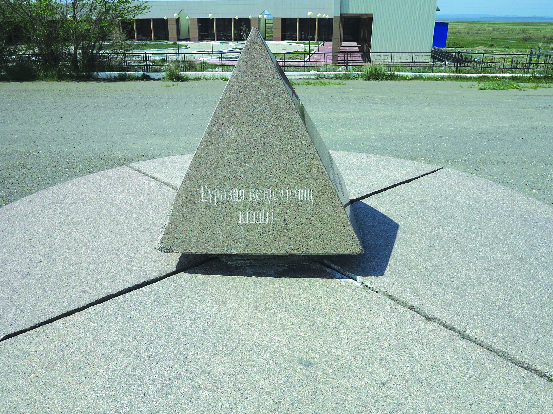
| Eurasien | Datei:Flag of Kazakhstan.svg Kasachstan | Shidebaj | 49° 7′ 18″ N, 79° 18′ 23,1″ O
{{#coordinates:49,1216628|79,306419|
|
dim= | globe= | name=Geografischer Mittelpunkt Éurasiens | region=KZ-10 | type=landmark
}} ||<ref group="Anmerkung">Eine bescheidene Pyramide, die den Mittelpunkt Eurasiens markiert, steht vor einstigen Wohnhaus des Dichters Abaj. „Zentrum des eurasischen Kontinents“ steht in Stein gemeißelt auf den vier Seitenwänden - in drei großen eurasischen Verkehrssprachen (Russisch, Chinesisch, Englisch) und einer kleinen (Kasachisch).
|
|||||
| Datei:Flag of India.svg Indien | Nagpur | 21° 9′ 14″ N, 79° 4′ 59″ O
{{#coordinates:21,153889|79,083056|
|
dim= | globe= | name=Geografischer Mittelpunkt Indiens | region=IN-MH | type=landmark
}} || <ref group="Anmerkung">Das Zentrum Indiens liegt im Stadtgebiet.
|
||||||
| Datei:Flag of Minnesota.svg Minnesota (Datei:Flag of the United States.svg Vereinigte Staaten) |
Stearns County | Sauk Centre | 45° 44′ N, 94° 57′ W
{{#coordinates:45,736389|−94,954167|
|
dim= | globe= | name=Geografischer Mittelpunkt Minnesota | region=US-MN | type=landmark
}} ||Die Stadt gilt als geographischer Mittelpunkt des Bundesstaates |
|||||
| Datei:Flag of New Zealand.svg Neuseeland | Nordinsel | Tararua Range | 41° 1′ 5,5″ S, 175° 21′ 44,2″ O
{{#coordinates:−41,018188888889|175,36228333333|
|
dim= | globe= | name=Geografischer Mittelpunkt Neuseeland | region=NZ-WGN | type=landmark }} || Centre of the Extended Continental Shelf of New Zealand<ref name="stuff_2021_07_13" /><ref name="BlackRonde2019" /> || | |||||
| Nordamerika | Datei:Flag of the United States.svg Vereinigte Staaten | Rugby (North Dakota) | 48° 21′ 16″ N, 99° 59′ 53,1″ W
{{#coordinates:48,354433|−99,998094|
|
dim= | globe= | name=Geographischer Mittelpunkt Nordamerika | region=US-ND | type=landmark
}} ||<ref group="Anmerkung">1931 wurde ein 4,5 m hoher Obelisk zur Markierung der geographischen Mitte Nordamerikas aufgestellt. 1971 wurde der Obelisk nach neuen Messungen an einer anderen Stelle neu aufgestellt. Doch ist es trotzdem noch bis heute umstritten, ob sich der Ort als geographische Mitte Nordamerikas bezeichnen kann. Letzte Messungen gehen davon aus, dass sich der geographische Mittelpunkt in ca. 25 km Entfernung von der Stadt befindet | |||||
| Datei:Flag of the United States.svg Vereinigte Staaten | Datei:Flag of South Dakota.svg South Dakota | Belle Fourche | incl. Alaska und Hawaii 44° 40′ 27,9″ N, 103° 51′ 9,9″ W {{#coordinates:44,67443|−103,852763|
|
dim= | globe= | name=Geographischer Mittelpunkt USA | region=US-SD | type=landmark
}} |
dim= | globe= | name=genauer Geographischer Mittelpunkt USA | region=US-SD | type=landmark
}} ||<ref group="Anmerkung">Die Lage der Markierung ist nicht ganz richtig. Sie wurde stellvertretend für den wahren Mittelpunkt im Tourismuscenter von Belle Fourche installiert. Das von U.S. Coast and Geodetic Survey berechnete Zentrum liegt ca. 32 km nördlich
|
| Datei:Flag of Kansas.svg Kansas | Lebanon | 39° 49′ 42,1″ N, 98° 34′ 46,1″ W
{{#coordinates:39,82836|−98,579486|
|
dim= | globe= | name=Mittelpunkt USA 48 Staaten | region=US-KS | type=landmark
}} ||Nur die 48 zusammenhängenden Bundesstaaten |
<templatestyles src="Vorlage:Galerie/styles.css" /> | |||||
| Datei:Flag of Russia.svg Russland | Datei:Flag of Krasnoyarsk Krai.svg Region Krasnojarsk | Wiwisee | 66° 24′ 52,9″ N, 94° 14′ 28,7″ O
{{#coordinates:66,414680555556|94,241319444444|
|
dim= | globe= | name=Geographischer Mittelpunkt Russlands | region=RU-KYA | type=landmark
}} ||Berechneter Mittelpunkt am Südufer des Wiwisees.<ref group="Anmerkung">Nach Überprüfung durch das Staatliche Amt für Geodäsie und Kartographie wurde dies offiziell anerkannt. Dort wurde daher am 21. August 1992 ein 7 m hohes Monument mit Inschrift aufgestellt. Am Seeufer stehen eine hölzerne Kapelle der Russisch-Orthodoxen Kirche und ein Kreuz, die am 9. September 2006 zu Ehren des heiligen Sergius von Radonesch (1319–1392) geweiht wurden. Nach der Annexion der Krim wurde ein weiteres Monument etwas weiter südlich errichtet. |
|||||
| Datei:Flag of Kazakhstan.svg Kasachstan | Qaraghandy | 25 Kilometer südlich von Ulytau, nahe dem Fluss Zhezdy, Qaraghandy;
90 Kilometer von Schesqasghan entfernt |
48° 25′ 54,5″ N, 66° 55′ 13″ O
{{#coordinates:48,431806|66,920278|
|
dim= | globe= | name=Mittelpunkt Kasachstans | region=KZ | type=landmark
}} |
Geografischer Mittelpunkt | ||||
| Datei:Flag of Chile.svg Chile
– (nur mit den nahe dem Festland vorgelagerten Inseln, innerhalb von 100 km) |
Datei:Flag of Argentina.svg Argentinien | 39° 42′ 3,5″ S, 71° 5′ 4,6″ W
{{#coordinates:−39,700972|−71,084611|
|
dim= | globe= | name=Mittelpunkte Chiles | region=AR | type=landmark
}} |
Geografische Mittelpunkte
(Befinden sich nicht auf dem Staatsgebiet) |
|||||
| - (mit allen Inseln, ohne Antarktisterritorium) | Pazifischer Ozean | 39° 42′ 3,5″ S, 81° 13′ 39,1″ W
{{#coordinates:−39,700972|−81,227528|
|
dim= | globe= | name=Mittelpunkte Chiles | region=XP | type=landmark
}} |
||||||
| Datei:Flag of Panama.svg Panama | Provinz Coclé | 8° 25′ 38,4″ N, 80° 6′ 19,5″ W
{{#coordinates:8,427333|−80,105417|
|
dim= | globe= | name=Mittelpunkt Panamas | region=PA | type=landmark
}} |
Geografischer Mittelpunkt | |||||
| Datei:Flag of Haiti.svg Haiti | Karibisches Meer | 13 km von der Île de la Gonâve entfernt | 19° 3′ 29,8″ N, 73° 19′ 36,7″ W
{{#coordinates:19,058278|−73,326861|
|
dim= | globe= | name=Mittelpunkt Haitis | region=HT | type=landmark
}} |
Geografischer Mittelpunkt
(Befindet sich nicht auf dem Staatsgebiet) |
||||
| Datei:Flag of The Gambia.svg Gambia | Lower River Region | 1 km vom Gambia und der Elephant Island entfernt,
nordwestlich von Bureng; Jarra East, Lower River Region |
13° 26′ 40,9″ N, 15° 18′ 27,1″ W
{{#coordinates:13,44469|−15,30753|
|
dim= | globe= | name=Mittelpunkt Gambias | region=GM | type=landmark
}} |
Geografischer Mittelpunkt | ||||
| Datei:Flag of the Republic of the Congo.svg Republik Kongo | Cuvette-Ouest | 1 km von dem Fluss Kouyou und der Siedlung Mboma und 20 km von Ewo entfernt | 0° 40′ 9,4″ S, 14° 54′ 3,2″ O
{{#coordinates:−0,66928|14,90089|
|
dim= | globe= | name=Mittelpunkt der Republik Kongo | region=CG | type=landmark
}} |
Geografischer Mittelpunkt | ||||
| Datei:Flag of Niger.svg Niger | Tchirozérine | 14 km von der Siedlung Tidène entfernt | 17° 35′ 48,8″ N, 8° 4′ 49,4″ O
{{#coordinates:17,59688|8,08038|
|
dim= | globe= | name=Mittelpunkt Nigers | region=NE-1 | type=landmark
}} |
Geografischer Mittelpunkt | ||||
| Plattensee | Komitat Veszprém | an der Ifjúsági Centrum Kht. Ltp.i m Badeort Zánka, Kreis Balatanfüredi, Komitat Veszprém, Mitteltransdanubien;
1 km vom Seeufer entfernt |
46° 52′ 56,2″ N, 17° 42′ 23,1″ O
{{#coordinates:46,88229|17,70641|
|
dim= | globe= | name=Mittelpunkt des Plattensees/Balaton | region=HU-VE | type=landmark
}} |
(Befindet sich nicht innerhalb des Sees) | ||||
| Schnittpunkt von Nullmeridian und Äquator | Meer | Östlicher Atlantischer Ozean 230 km südwestlich Golf von Guinea <ref group="Anmerkung">Entgegen manchen Annahmen und Veröffentlichungen kreuzen sich der Äquator und der Nullmeridian nicht im Golf, sondern rund 230 km weiter südwestlich. Nach der Definition der International Hydrographic Organization wird der Golf durch das Cape Palmas in Liberia und das Cap Lopez in Gabun begrenzt.
|
0° N/S, 0° O/W
{{#coordinates:0|0|
|
dim=1000000 | globe= | name=Schnittpunkt von Nullmeridian und Äquator | region=XA | type=waterbody
}} |
Datei:Golf-Nullpunkz.png | Datei:Borda do mundo (4942486361).jpg | |||
| allen Landflächen der Erde | Datei:Flag of Turkey.svg Türkei | Kıcıklar, Beyoğlan, İskilip, Çorum, Schwarzmeerregion | 41° N, 35° O
{{#coordinates:40,866666666667|34,566666666667|
|
dim=1000000 | globe= | name=Geografischer Mittelpunkt der Erde | region=TR-19 | type=landmark
}} ||Mittelpunkt der Erdoberfläche, Geometrischer Schwerpunkt
|
.svg)
.jpg)
Anmerkungen
<references group="Anmerkung" responsive />
Weblinks
- Gesammelte geografische Mittelpunkte in Europa, „Die Weltenbummler“, Michael Moll 2000–2019
Einzelnachweise
<references responsive> <ref name="stuff_2021_07_13"> {{Modul:Vorlage:lang}} Modul:Multilingual:153: attempt to index field 'data' (a nil value): {{Modul:Vorlage:lang}} Modul:Multilingual:153: attempt to index field 'data' (a nil value). In: {{Modul:Vorlage:lang}} Modul:Multilingual:153: attempt to index field 'data' (a nil value). 13. Juli 2021, abgerufen am 26. Mai 2022 (Lua-Fehler in Modul:Multilingual, Zeile 153: attempt to index field 'data' (a nil value)). </ref> <ref name="BlackRonde2019"> </ref> </references>
- Seiten mit Skriptfehlern
- Wikipedia:Defekter Dateilink
- Wikipedia:Defekte Weblinks/Ungeprüfte Archivlinks 2022-03
- Wikipedia:Bilderwunsch an bestimmtem Ort
- MediaWiki:Gadget/templateGallery
- Wikipedia:Weblink offline IABot
- Wikipedia:Defekte Weblinks/Ungeprüfte Botmarkierungen 2022-03
- Wikipedia:Vorlagenfehler/Parameter:Datum
- Wikipedia:Lagewunsch (RU)
- Wikipedia:Lagewunsch (landmark)
- Wikipedia:Lagewunsch (TR)
- Wikipedia:Vorlagenfehler/Vorlage:Literatur/Interner Fehler
- Liste (Geographie)
- Geographischer Mittelpunkt