Elizabeth Islands
| {{#if:|{{{Name}}}|{{#invoke:WLink|getArticleBase}}}} | |||||||||||||||||||||||||||||||||||||||||||||||||||||||||||||||||||||||||||||||||||||||||||||||||||||||||||||||||||||||||||||||||||||||||||||||||||||||||||||||||||||||||||||||||||||||||||||||||||||||||||||||||||||||||||||||||||||||||||||||||||||||||||||||||||||||||||||||||||||||||||||||||||||||||||||||||||||||||||||||||
|---|---|---|---|---|---|---|---|---|---|---|---|---|---|---|---|---|---|---|---|---|---|---|---|---|---|---|---|---|---|---|---|---|---|---|---|---|---|---|---|---|---|---|---|---|---|---|---|---|---|---|---|---|---|---|---|---|---|---|---|---|---|---|---|---|---|---|---|---|---|---|---|---|---|---|---|---|---|---|---|---|---|---|---|---|---|---|---|---|---|---|---|---|---|---|---|---|---|---|---|---|---|---|---|---|---|---|---|---|---|---|---|---|---|---|---|---|---|---|---|---|---|---|---|---|---|---|---|---|---|---|---|---|---|---|---|---|---|---|---|---|---|---|---|---|---|---|---|---|---|---|---|---|---|---|---|---|---|---|---|---|---|---|---|---|---|---|---|---|---|---|---|---|---|---|---|---|---|---|---|---|---|---|---|---|---|---|---|---|---|---|---|---|---|---|---|---|---|---|---|---|---|---|---|---|---|---|---|---|---|---|---|---|---|---|---|---|---|---|---|---|---|---|---|---|---|---|---|---|---|---|---|---|---|---|---|---|---|---|---|---|---|---|---|---|---|---|---|---|---|---|---|---|---|---|---|---|---|---|---|---|---|---|---|---|---|---|---|---|---|---|---|---|---|---|---|---|---|---|---|---|---|---|---|---|---|---|---|---|---|---|---|---|---|---|---|---|---|---|---|---|---|---|---|---|---|---|---|---|---|---|---|---|---|---|---|---|---|---|---|---|---|
}} | |||||||||||||||||||||||||||||||||||||||||||||||||||||||||||||||||||||||||||||||||||||||||||||||||||||||||||||||||||||||||||||||||||||||||||||||||||||||||||||||||||||||||||||||||||||||||||||||||||||||||||||||||||||||||||||||||||||||||||||||||||||||||||||||||||||||||||||||||||||||||||||||||||||||||||||||||||||||||||||||||
| Gewässer | {{#ifexist: Buzzards Bay, Vineyard Sound|[[Buzzards Bay, Vineyard Sound]]|Buzzards Bay, Vineyard Sound}} | {{#if:1663077 | colspan="2" | Pflichtparameter GEWAESSER fehlt }}
}} | ||||||||||||||||||||||||||||||||||||||||||||||||||||||||||||||||||||||||||||||||||||||||||||||||||||||||||||||||||||||||||||||||||||||||||||||||||||||||||||||||||||||||||||||||||||||||||||||||||||||||||||||||||||||||||||||||||||||||||||||||||||||||||||||||||||||||||||||||||||||||||||||||||||||||||||||||||||||||||||||
| Archipel | Outer Lands|Outer Lands}}
}} | ||||||||||||||||||||||||||||||||||||||||||||||||||||||||||||||||||||||||||||||||||||||||||||||||||||||||||||||||||||||||||||||||||||||||||||||||||||||||||||||||||||||||||||||||||||||||||||||||||||||||||||||||||||||||||||||||||||||||||||||||||||||||||||||||||||||||||||||||||||||||||||||||||||||||||||||||||||||||||||||||
| 1|1}}|{{#switch:{{Info ISO-3166-2:{{#titleparts:US-MA|1|1}}|level}} | 1|2={{Info ISO-3166-2:{{#titleparts:US-MA|1|1}}|{{#switch:top | 1|1}}|level}} | adm2nd=2 | adm1st=1 | country=0 | #default=top
}} }} |
#default={{#switch: top | continent = | level = | maxlevel = | acronym = | top = ?? | upper = | admtype = | admtypelink = | admname = | lemma = | 0 = | 1 = | 2 = | map = Erde | flag = Flag of None.svg
}} }}}} |
LI|CH|GB={{#switch:{{#if:{{#titleparts:US-MA|1|2}}|{{#switch:{{Info ISO-3166-2:{{#titleparts:US-MA|1|2}}|level}} | 1|2={{Info ISO-3166-2:{{#titleparts:US-MA|1|2}}|{{#switch:top | 1|2}}|level}} | adm2nd=2 | adm1st=1 | country=0 | #default=top
}} }} |
#default={{#switch: top | continent = | level = | maxlevel = | acronym = | top = ?? | upper = | admtype = | admtypelink = | admname = | lemma = | 0 = | 1 = | 2 = | map = Erde | flag = Flag of None.svg
}} }}}} |
LI|CH|GB={{#switch:{{#if:{{#titleparts:US-MA|1|3}}|{{#switch:{{Info ISO-3166-2:{{#titleparts:US-MA|1|3}}|level}} | 1|2={{Info ISO-3166-2:{{#titleparts:US-MA|1|3}}|{{#switch:top | 1|3}}|level}} | adm2nd=2 | adm1st=1 | country=0 | #default=top
}} }} |
#default={{#switch: top | continent = | level = | maxlevel = | acronym = | top = ?? | upper = | admtype = | admtypelink = | admname = | lemma = | 0 = | 1 = | 2 = | map = Erde | flag = Flag of None.svg
}} }}}} |
CH|GB={{#switch:{{#if:{{#titleparts:US-MA|1|4}}|{{#switch:{{Info ISO-3166-2:{{#titleparts:US-MA|1|4}}|level}} | 1|2={{Info ISO-3166-2:{{#titleparts:US-MA|1|4}}|{{#switch:top | 1|4}}|level}} | adm2nd=2 | adm1st=1 | country=0 | #default=top
}} }} |
#default={{#switch: top | continent = | level = | maxlevel = | acronym = | top = ?? | upper = | admtype = | admtypelink = | admname = | lemma = | 0 = | 1 = | 2 = | map = Erde | flag = Flag of None.svg
}} }}}}||LI|CH|GB=|#default=DMS/}} |
#default=DMS/}} | #default=DMS/}} | #default=DMS/}}{{#switch:CH | 1|1}}|{{#switch:{{Info ISO-3166-2:{{#titleparts:US-MA|1|1}}|level}} | 1|2={{Info ISO-3166-2:{{#titleparts:US-MA|1|1}}|{{#switch:top | 1|1}}|level}} | adm2nd=2 | adm1st=1 | country=0 | #default=top
}} }} |
#default={{#switch: top | continent = | level = | maxlevel = | acronym = | top = ?? | upper = | admtype = | admtypelink = | admname = | lemma = | 0 = | 1 = | 2 = | map = Erde | flag = Flag of None.svg
}} }}}} |
1|2}}|{{#switch:{{Info ISO-3166-2:{{#titleparts:US-MA|1|2}}|level}} | 1|2={{Info ISO-3166-2:{{#titleparts:US-MA|1|2}}|{{#switch:top | 1|2}}|level}} | adm2nd=2 | adm1st=1 | country=0 | #default=top
}} }} |
#default={{#switch: top | continent = | level = | maxlevel = | acronym = | top = ?? | upper = | admtype = | admtypelink = | admname = | lemma = | 0 = | 1 = | 2 = | map = Erde | flag = Flag of None.svg
}} }}}} |
1|3}}|{{#switch:{{Info ISO-3166-2:{{#titleparts:US-MA|1|3}}|level}} | 1|2={{Info ISO-3166-2:{{#titleparts:US-MA|1|3}}|{{#switch:top | 1|3}}|level}} | adm2nd=2 | adm1st=1 | country=0 | #default=top
}} }} |
#default={{#switch: top | continent = | level = | maxlevel = | acronym = | top = ?? | upper = | admtype = | admtypelink = | admname = | lemma = | 0 = | 1 = | 2 = | map = Erde | flag = Flag of None.svg
}} }}}} |
1|4}}|{{#switch:{{Info ISO-3166-2:{{#titleparts:US-MA|1|4}}|level}} | 1|2={{Info ISO-3166-2:{{#titleparts:US-MA|1|4}}|{{#switch:top | 1|4}}|level}} | adm2nd=2 | adm1st=1 | country=0 | #default=top
}} }} |
#default={{#switch: top | continent = | level = | maxlevel = | acronym = | top = ?? | upper = | admtype = | admtypelink = | admname = | lemma = | 0 = | 1 = | 2 = | map = Erde | flag = Flag of None.svg
}} }}}}=CH1903/CH1903 |
#default={{#switch:LI | 1|1}}|{{#switch:{{Info ISO-3166-2:{{#titleparts:US-MA|1|1}}|level}} | 1|2={{Info ISO-3166-2:{{#titleparts:US-MA|1|1}}|{{#switch:top | 1|1}}|level}} | adm2nd=2 | adm1st=1 | country=0 | #default=top
}} }} |
#default={{#switch: top | continent = | level = | maxlevel = | acronym = | top = ?? | upper = | admtype = | admtypelink = | admname = | lemma = | 0 = | 1 = | 2 = | map = Erde | flag = Flag of None.svg
}} }}}} |
1|2}}|{{#switch:{{Info ISO-3166-2:{{#titleparts:US-MA|1|2}}|level}} | 1|2={{Info ISO-3166-2:{{#titleparts:US-MA|1|2}}|{{#switch:top | 1|2}}|level}} | adm2nd=2 | adm1st=1 | country=0 | #default=top
}} }} |
#default={{#switch: top | continent = | level = | maxlevel = | acronym = | top = ?? | upper = | admtype = | admtypelink = | admname = | lemma = | 0 = | 1 = | 2 = | map = Erde | flag = Flag of None.svg
}} }}}} |
1|3}}|{{#switch:{{Info ISO-3166-2:{{#titleparts:US-MA|1|3}}|level}} | 1|2={{Info ISO-3166-2:{{#titleparts:US-MA|1|3}}|{{#switch:top | 1|3}}|level}} | adm2nd=2 | adm1st=1 | country=0 | #default=top
}} }} |
#default={{#switch: top | continent = | level = | maxlevel = | acronym = | top = ?? | upper = | admtype = | admtypelink = | admname = | lemma = | 0 = | 1 = | 2 = | map = Erde | flag = Flag of None.svg
}} }}}} |
1|4}}|{{#switch:{{Info ISO-3166-2:{{#titleparts:US-MA|1|4}}|level}} | 1|2={{Info ISO-3166-2:{{#titleparts:US-MA|1|4}}|{{#switch:top | 1|4}}|level}} | adm2nd=2 | adm1st=1 | country=0 | #default=top
}} }} |
#default={{#switch: top | continent = | level = | maxlevel = | acronym = | top = ?? | upper = | admtype = | admtypelink = | admname = | lemma = | 0 = | 1 = | 2 = | map = Erde | flag = Flag of None.svg
}} }}}}=CH1903/CH1903 |
#default=DMS/DMS
}}}} |
DMS/CH1903/CH1903={{#if:Geographische Lage|Geographische Lage|Koordinaten}}, (CH) | CH1903/CH1903={{#if:Geographische Lage|Geographische Lage|Koordinaten}} | OSGB36/OSGB36=Ordnance Survey GB | UTM=UTM-Koordinaten | #default={{#if:Geographische Lage|Geographische Lage|Koordinaten}}
}} |
y|Simple|Complex}}|NS=41/27//N|EW=70/49//W|type=isle|region=US-MA|globe=|dim=|elevation=|pop=86|lw=|name={{#invoke:Coordinates/kml|kmlTitle|1={{#if: |{{{Name}}}|{{#invoke:WLink|getArticleBase}}}}}}|article={{#if: | text=/|sortkey=|tooltip=|tooltipformat=|map=|mapsize=|maplevel=|maptype=|maplabel=|maplayer=|mapcaption=}}{{#if:|{{#switch:5 | 1 = Gradzahl-Fehler: {{#iferror:{{{1}}} | NS: {{{1}}} |
}} {{#iferror:
|
EW: |
}}{{#switch:0
|
6|14=
}} |
2 = nicht im Bereich von {{{1}}}{{#switch:0 | 6|14=
}} |
3 = {{#switch: {{{type}}} | state|adm1st|adm2nd|city|isle|airport|mountain|waterbody|forest|landmark= | example={{#if: | falscher Wert ›example‹ im Artikelnamensraum
}} |
kein Wert | falscher Wert ›{{{type}}}‹
}} in type-Parameter{{#switch:0 |
6|14=
}}
}} {{#if: {{{rg}}}
|
region-Parameter fehlt{{#if: |
}}
}} {{#iferror: {{{elevation}}}
|
{{{elevation}}}{{#switch:0 | 6|14=
}} |
}} {{#iferror: {{{pop}}}
|
{{{pop}}}{{#switch:0 | 6|14=
}} |
}} |
, 2:}}{{#if:|, 3:}}{{#if:|, 4:}} {{#if:|usw.}}{{#switch:0 | 6|14=
}} |
8 = Parameter name fehlt in Fließtextkoordinate{{#switch:0 | 6|14=
}} |
10= | #default=coordinates error
}}}} | |||||
| [[Datei:|300px|zentriert|alt=|Karte von {{#if: Elizabeth Islands|Elizabeth Islands|Elizabeth Islands}}]] | {{#switch: |none|keine|-= | colspan="2" style="text-align:center; padding:0;" |
{{ Positionskarte {{#if: ||ISO 3166-2 }}
|
1={{#if: | {{#ifeq:/US-MA | 1|{{#expr:1+1}}}} | 1|{{#expr:1+1}}}}
}} }} |
label= Elizabeth Islands | {{{Name}}}|{{#invoke:WLink|getArticleBase}}}} | position=none | lat=41/27//N | long=70/49//W | pop=86 |elevation= |region=US-MA | dim= | width=300 | border=none | caption= | marksize=25 | maptype=relief
}} | |||||||||||||||||||||||||||||||||||||||||||||||||||||||||||||||||||||||||||||||||||||||||||||||||||||||||||||||||||||||||||||||||||||||||||||||||||||||||||||||||||||||||||||||||||||||||||||||||||||||||||||||||||||||||||||||||||||||||||||||||||||||||||||||||||||||||||||||||||||||||||||||||||||||||||||||
| Anzahl der Inseln | 11 | {{#if:1663077 | colspan="2" | Pflichtparameter INSELN fehlt }}
}} | ||||||||||||||||||||||||||||||||||||||||||||||||||||||||||||||||||||||||||||||||||||||||||||||||||||||||||||||||||||||||||||||||||||||||||||||||||||||||||||||||||||||||||||||||||||||||||||||||||||||||||||||||||||||||||||||||||||||||||||||||||||||||||||||||||||||||||||||||||||||||||||||||||||||||||||||||||||||||||||||
| Hauptinsel | Cuttyhunk
}} | ||||||||||||||||||||||||||||||||||||||||||||||||||||||||||||||||||||||||||||||||||||||||||||||||||||||||||||||||||||||||||||||||||||||||||||||||||||||||||||||||||||||||||||||||||||||||||||||||||||||||||||||||||||||||||||||||||||||||||||||||||||||||||||||||||||||||||||||||||||||||||||||||||||||||||||||||||||||||||||||||
| Gesamte Landfläche | Masz}} | {{#if:1663077 | colspan="2" | Pflichtparameter FLAECHE fehlt }}
}} | ||||||||||||||||||||||||||||||||||||||||||||||||||||||||||||||||||||||||||||||||||||||||||||||||||||||||||||||||||||||||||||||||||||||||||||||||||||||||||||||||||||||||||||||||||||||||||||||||||||||||||||||||||||||||||||||||||||||||||||||||||||||||||||||||||||||||||||||||||||||||||||||||||||||||||||||||||||||||||||||
| Einwohner | 0|unbewohnt{{#ifeq: | |}} |Vorlage:FormatNumDef {{#if:2000|(2000)}} }}
}} | ||||||||||||||||||||||||||||||||||||||||||||||||||||||||||||||||||||||||||||||||||||||||||||||||||||||||||||||||||||||||||||||||||||||||||||||||||||||||||||||||||||||||||||||||||||||||||||||||||||||||||||||||||||||||||||||||||||||||||||||||||||||||||||||||||||||||||||||||||||||||||||||||||||||||||||||||||||||||||||||||
}} | |||||||||||||||||||||||||||||||||||||||||||||||||||||||||||||||||||||||||||||||||||||||||||||||||||||||||||||||||||||||||||||||||||||||||||||||||||||||||||||||||||||||||||||||||||||||||||||||||||||||||||||||||||||||||||||||||||||||||||||||||||||||||||||||||||||||||||||||||||||||||||||||||||||||||||||||||||||||||||||||||
{{#if: 41/27//N |{{#if: US-MA||
}} {{#switch: |none|keine|-=
}}
}}{{#if: || {{#if: Buzzards Bay, Vineyard Sound||}} }}{{#if: || {{#if: 34.55||}} }}{{#if: || {{#if: 11||}} }} Die Elizabeth Islands sind eine kleine Inselkette, die sich von der südlichen Küste von Cape Cod (Massachusetts in den Vereinigten Staaten) ausdehnen. Sie liegen an der äußeren Buzzards Bay nördlich von Martha’s Vineyard und bilden die Gemeinde Gosnold im Dukes County. Alle Inseln der Elizabeth Islands außer Cuttyhunk und Penikese sind im Privatbesitz der Familie Forbes.
1641 kaufte Thomas Mayhew, Sir of Watertown die Inseln (mit Nantucket und Martha’s Vineyard) von William Alexander, dem Earl of Sterling. Vor der Gründung der Province of Massachusetts Bay waren die Inseln Teil des heute nicht mehr existierenden Dukes County (New York). Die gesamte Landfläche der Inseln beträgt 34,55 km² und es gab eine dauerhafte Bevölkerung von 86 Personen nach dem Zensus von 2000 (davon Naushon Island 30 und Cuttyhunk 56).
Benannte Inseln
| Nr. | Insel | Fläche km² |
Koordinaten | Bemerkungen | ||||||||||||||||||||||||||||||||
|---|---|---|---|---|---|---|---|---|---|---|---|---|---|---|---|---|---|---|---|---|---|---|---|---|---|---|---|---|---|---|---|---|---|---|---|---|
| 1 | Nonamesset | 1,398 | y|Simple|Complex}}|NS=41/30/30.14/N|EW=70/41/14.78/W|type=isle|region=US-MA|globe=|dim=900|elevation=|pop=|lw=|name={{#invoke:Coordinates/kml|kmlTitle|1=Nonamesset Island}}|article=|text=DMS|sortkey=NS|tooltip=|tooltipformat=|map=|mapsize=|maplevel=|maptype=|maplabel=|maplayer=|mapcaption=}}{{#if:|{{#switch:5 | 1 = Gradzahl-Fehler: {{#iferror:{{{1}}} | NS: {{{1}}} |
}} {{#iferror:
|
EW: |
}}{{#switch:0
|
6|14=
}} |
2 = nicht im Bereich von {{{1}}}{{#switch:0 | 6|14=
}} |
3 = {{#switch: {{{type}}} | state|adm1st|adm2nd|city|isle|airport|mountain|waterbody|forest|landmark= | example={{#if: | falscher Wert ›example‹ im Artikelnamensraum
}} |
kein Wert | falscher Wert ›{{{type}}}‹
}} in type-Parameter{{#switch:0 |
6|14=
}}
}} {{#if: {{{rg}}}
|
region-Parameter fehlt{{#if: |
}}
}} {{#iferror: {{{elevation}}}
|
{{{elevation}}}{{#switch:0 | 6|14=
}} |
}} {{#iferror: {{{pop}}}
|
{{{pop}}}{{#switch:0 | 6|14=
}} |
}} |
, 2:}}{{#if:|, 3:}}{{#if:|, 4:}} {{#if:|usw.}}{{#switch:0 | 6|14=
}} |
8 = Parameter name fehlt in Fließtextkoordinate{{#switch:0 | 6|14=
}} |
10= | #default=coordinates error
}}}} || östlichste Insel, dem Festland bei Falmouth nächstliegendste Insel | ||||
| 2 | Cedar | |||||||||||||||||||||||||||||||||||
| 3 | Veckatimest Island | 0,0675 | y|Simple|Complex}}|NS=41/30/27/N|EW=70/41/58/W|type=isle|region=US-MA|globe=|dim=900|elevation=|pop=|lw=|name={{#invoke:Coordinates/kml|kmlTitle|1=Veckatimest}}|article=|text=DMS|sortkey=NS|tooltip=|tooltipformat=|map=|mapsize=|maplevel=|maptype=|maplabel=|maplayer=|mapcaption=}}{{#if:|{{#switch:5 | 1 = Gradzahl-Fehler: {{#iferror:{{{1}}} | NS: {{{1}}} |
}} {{#iferror:
|
EW: |
}}{{#switch:0
|
6|14=
}} |
2 = nicht im Bereich von {{{1}}}{{#switch:0 | 6|14=
}} |
3 = {{#switch: {{{type}}} | state|adm1st|adm2nd|city|isle|airport|mountain|waterbody|forest|landmark= | example={{#if: | falscher Wert ›example‹ im Artikelnamensraum
}} |
kein Wert | falscher Wert ›{{{type}}}‹
}} in type-Parameter{{#switch:0 |
6|14=
}}
}} {{#if: {{{rg}}}
|
region-Parameter fehlt{{#if: |
}}
}} {{#iferror: {{{elevation}}}
|
{{{elevation}}}{{#switch:0 | 6|14=
}} |
}} {{#iferror: {{{pop}}}
|
{{{pop}}}{{#switch:0 | 6|14=
}} |
}} |
, 2:}}{{#if:|, 3:}}{{#if:|, 4:}} {{#if:|usw.}}{{#switch:0 | 6|14=
}} |
8 = Parameter name fehlt in Fließtextkoordinate{{#switch:0 | 6|14=
}} |
10= | #default=coordinates error
}}}} || | ||||
| 4 | Monohansett | |||||||||||||||||||||||||||||||||||
| 5 | Bull | |||||||||||||||||||||||||||||||||||
| 6 | Uncatena | 0,492 | y|Simple|Complex}}|NS=41/31/0.04/N|EW=70/42/20/W|type=isle|region=US-MA|globe=|dim=900|elevation=|pop=|lw=|name={{#invoke:Coordinates/kml|kmlTitle|1=Uncatena Island}}|article=|text=DMS|sortkey=NS|tooltip=|tooltipformat=|map=|mapsize=|maplevel=|maptype=|maplabel=|maplayer=|mapcaption=}}{{#if:|{{#switch:5 | 1 = Gradzahl-Fehler: {{#iferror:{{{1}}} | NS: {{{1}}} |
}} {{#iferror:
|
EW: |
}}{{#switch:0
|
6|14=
}} |
2 = nicht im Bereich von {{{1}}}{{#switch:0 | 6|14=
}} |
3 = {{#switch: {{{type}}} | state|adm1st|adm2nd|city|isle|airport|mountain|waterbody|forest|landmark= | example={{#if: | falscher Wert ›example‹ im Artikelnamensraum
}} |
kein Wert | falscher Wert ›{{{type}}}‹
}} in type-Parameter{{#switch:0 |
6|14=
}}
}} {{#if: {{{rg}}}
|
region-Parameter fehlt{{#if: |
}}
}} {{#iferror: {{{elevation}}}
|
{{{elevation}}}{{#switch:0 | 6|14=
}} |
}} {{#iferror: {{{pop}}}
|
{{{pop}}}{{#switch:0 | 6|14=
}} |
}} |
, 2:}}{{#if:|, 3:}}{{#if:|, 4:}} {{#if:|usw.}}{{#switch:0 | 6|14=
}} |
8 = Parameter name fehlt in Fließtextkoordinate{{#switch:0 | 6|14=
}} |
10= | #default=coordinates error
}}}} || unbewohnt (nach Zensus von 2000) | ||||
| 7 | Bachelor | |||||||||||||||||||||||||||||||||||
| 8 | Naushon | 19,180 | y|Simple|Complex}}|NS=41/29/0/N|EW=70/46/0/W|type=isle|region=US-MA|globe=|dim=900|elevation=|pop=|lw=|name={{#invoke:Coordinates/kml|kmlTitle|1=Naushon Island}}|article=|text=DMS|sortkey=NS|tooltip=|tooltipformat=|map=|mapsize=|maplevel=|maptype=|maplabel=|maplayer=|mapcaption=}}{{#if:|{{#switch:5 | 1 = Gradzahl-Fehler: {{#iferror:{{{1}}} | NS: {{{1}}} |
}} {{#iferror:
|
EW: |
}}{{#switch:0
|
6|14=
}} |
2 = nicht im Bereich von {{{1}}}{{#switch:0 | 6|14=
}} |
3 = {{#switch: {{{type}}} | state|adm1st|adm2nd|city|isle|airport|mountain|waterbody|forest|landmark= | example={{#if: | falscher Wert ›example‹ im Artikelnamensraum
}} |
kein Wert | falscher Wert ›{{{type}}}‹
}} in type-Parameter{{#switch:0 |
6|14=
}}
}} {{#if: {{{rg}}}
|
region-Parameter fehlt{{#if: |
}}
}} {{#iferror: {{{elevation}}}
|
{{{elevation}}}{{#switch:0 | 6|14=
}} |
}} {{#iferror: {{{pop}}}
|
{{{pop}}}{{#switch:0 | 6|14=
}} |
}} |
, 2:}}{{#if:|, 3:}}{{#if:|, 4:}} {{#if:|usw.}}{{#switch:0 | 6|14=
}} |
8 = Parameter name fehlt in Fließtextkoordinate{{#switch:0 | 6|14=
}} |
10= | #default=coordinates error
}}}} || 30 Einwohner (2000); 12,3 km lang; gehört zum Naushon Island Trust der Forbes-Familien; nicht öffentlich | ||||
| 9 | Weepecket Islands | 0,051 | y|Simple|Complex}}|NS=41/31/0/N|EW=70/44/11/W|type=isle|region=US-MA|globe=|dim=900|elevation=|pop=|lw=|name={{#invoke:Coordinates/kml|kmlTitle|1=Weepecket Islands}}|article=|text=DMS|sortkey=NS|tooltip=|tooltipformat=|map=|mapsize=|maplevel=|maptype=|maplabel=|maplayer=|mapcaption=}}{{#if:|{{#switch:5 | 1 = Gradzahl-Fehler: {{#iferror:{{{1}}} | NS: {{{1}}} |
}} {{#iferror:
|
EW: |
}}{{#switch:0
|
6|14=
}} |
2 = nicht im Bereich von {{{1}}}{{#switch:0 | 6|14=
}} |
3 = {{#switch: {{{type}}} | state|adm1st|adm2nd|city|isle|airport|mountain|waterbody|forest|landmark= | example={{#if: | falscher Wert ›example‹ im Artikelnamensraum
}} |
kein Wert | falscher Wert ›{{{type}}}‹
}} in type-Parameter{{#switch:0 |
6|14=
}}
}} {{#if: {{{rg}}}
|
region-Parameter fehlt{{#if: |
}}
}} {{#iferror: {{{elevation}}}
|
{{{elevation}}}{{#switch:0 | 6|14=
}} |
}} {{#iferror: {{{pop}}}
|
{{{pop}}}{{#switch:0 | 6|14=
}} |
}} |
, 2:}}{{#if:|, 3:}}{{#if:|, 4:}} {{#if:|usw.}}{{#switch:0 | 6|14=
}} |
8 = Parameter name fehlt in Fließtextkoordinate{{#switch:0 | 6|14=
}} |
10= | #default=coordinates error
}}}} || unbewohnt; drei kleine, öffentlich zugängliche Inseln nördlich von Zentralnaushon; in Besitz der Forbes-Familie | ||||
| 10 | Pasque | 3,450 | y|Simple|Complex}}|NS=41/27/0/N|EW=70/49/35/W|type=isle|region=US-MA|globe=|dim=900|elevation=|pop=|lw=|name={{#invoke:Coordinates/kml|kmlTitle|1=Pasque Island}}|article=|text=DMS|sortkey=NS|tooltip=|tooltipformat=|map=|mapsize=|maplevel=|maptype=|maplabel=|maplayer=|mapcaption=}}{{#if:|{{#switch:5 | 1 = Gradzahl-Fehler: {{#iferror:{{{1}}} | NS: {{{1}}} |
}} {{#iferror:
|
EW: |
}}{{#switch:0
|
6|14=
}} |
2 = nicht im Bereich von {{{1}}}{{#switch:0 | 6|14=
}} |
3 = {{#switch: {{{type}}} | state|adm1st|adm2nd|city|isle|airport|mountain|waterbody|forest|landmark= | example={{#if: | falscher Wert ›example‹ im Artikelnamensraum
}} |
kein Wert | falscher Wert ›{{{type}}}‹
}} in type-Parameter{{#switch:0 |
6|14=
}}
}} {{#if: {{{rg}}}
|
region-Parameter fehlt{{#if: |
}}
}} {{#iferror: {{{elevation}}}
|
{{{elevation}}}{{#switch:0 | 6|14=
}} |
}} {{#iferror: {{{pop}}}
|
{{{pop}}}{{#switch:0 | 6|14=
}} |
}} |
, 2:}}{{#if:|, 3:}}{{#if:|, 4:}} {{#if:|usw.}}{{#switch:0 | 6|14=
}} |
8 = Parameter name fehlt in Fließtextkoordinate{{#switch:0 | 6|14=
}} |
10= | #default=coordinates error
}}}} || unbewohnt; 2,4 km lang; von einem Teil der Forbes-Familie besessen und mit Giftefeu bedeckt; ein seichter Tidenbach bahnt sich seinen Weg durch die Insel | ||||
| 11 | Nashawena | 7,076 | y|Simple|Complex}}|NS=41/25/45/N|EW=70/52/30/W|type=isle|region=US-MA|globe=|dim=900|elevation=|pop=|lw=|name={{#invoke:Coordinates/kml|kmlTitle|1=Nashawena Island}}|article=|text=DMS|sortkey=NS|tooltip=|tooltipformat=|map=|mapsize=|maplevel=|maptype=|maplabel=|maplayer=|mapcaption=}}{{#if:|{{#switch:5 | 1 = Gradzahl-Fehler: {{#iferror:{{{1}}} | NS: {{{1}}} |
}} {{#iferror:
|
EW: |
}}{{#switch:0
|
6|14=
}} |
2 = nicht im Bereich von {{{1}}}{{#switch:0 | 6|14=
}} |
3 = {{#switch: {{{type}}} | state|adm1st|adm2nd|city|isle|airport|mountain|waterbody|forest|landmark= | example={{#if: | falscher Wert ›example‹ im Artikelnamensraum
}} |
kein Wert | falscher Wert ›{{{type}}}‹
}} in type-Parameter{{#switch:0 |
6|14=
}}
}} {{#if: {{{rg}}}
|
region-Parameter fehlt{{#if: |
}}
}} {{#iferror: {{{elevation}}}
|
{{{elevation}}}{{#switch:0 | 6|14=
}} |
}} {{#iferror: {{{pop}}}
|
{{{pop}}}{{#switch:0 | 6|14=
}} |
}} |
, 2:}}{{#if:|, 3:}}{{#if:|, 4:}} {{#if:|usw.}}{{#switch:0 | 6|14=
}} |
8 = Parameter name fehlt in Fließtextkoordinate{{#switch:0 | 6|14=
}} |
10= | #default=coordinates error
}}}} || bewohnt; 4,8 km lang; von einem anderen Teil der Forbes-Familie besessen; grasendes Vieh | ||||
| 12 | Gull Island | |||||||||||||||||||||||||||||||||||
| 13 | Penikese Island | 0,182 | y|Simple|Complex}}|NS=41/27/05/N|EW=70/55/21/W|type=isle|region=US-MA|globe=|dim=900|elevation=|pop=|lw=|name={{#invoke:Coordinates/kml|kmlTitle|1=Pekinese}}|article=|text=DMS|sortkey=NS|tooltip=|tooltipformat=|map=|mapsize=|maplevel=|maptype=|maplabel=|maplayer=|mapcaption=}}{{#if:|{{#switch:5 | 1 = Gradzahl-Fehler: {{#iferror:{{{1}}} | NS: {{{1}}} |
}} {{#iferror:
|
EW: |
}}{{#switch:0
|
6|14=
}} |
2 = nicht im Bereich von {{{1}}}{{#switch:0 | 6|14=
}} |
3 = {{#switch: {{{type}}} | state|adm1st|adm2nd|city|isle|airport|mountain|waterbody|forest|landmark= | example={{#if: | falscher Wert ›example‹ im Artikelnamensraum
}} |
kein Wert | falscher Wert ›{{{type}}}‹
}} in type-Parameter{{#switch:0 |
6|14=
}}
}} {{#if: {{{rg}}}
|
region-Parameter fehlt{{#if: |
}}
}} {{#iferror: {{{elevation}}}
|
{{{elevation}}}{{#switch:0 | 6|14=
}} |
}} {{#iferror: {{{pop}}}
|
{{{pop}}}{{#switch:0 | 6|14=
}} |
}} |
, 2:}}{{#if:|, 3:}}{{#if:|, 4:}} {{#if:|usw.}}{{#switch:0 | 6|14=
}} |
8 = Parameter name fehlt in Fließtextkoordinate{{#switch:0 | 6|14=
}} |
10= | #default=coordinates error
}}}} || unbewohnt; ca. 0,8 km nördlich von Nashawena und Cuttyhunk; Ort einer Reform School | ||||
| 14 | Cuttyhunk | 2,347 | y|Simple|Complex}}|NS=41/25/8/N|EW=70/56/2/W|type=isle|region=US-MA|globe=|dim=900|elevation=|pop=|lw=|name={{#invoke:Coordinates/kml|kmlTitle|1=Cuttyhunk}}|article=|text=DMS|sortkey=NS|tooltip=|tooltipformat=|map=|mapsize=|maplevel=|maptype=|maplabel=|maplayer=|mapcaption=}}{{#if:|{{#switch:5 | 1 = Gradzahl-Fehler: {{#iferror:{{{1}}} | NS: {{{1}}} |
}} {{#iferror:
|
EW: |
}}{{#switch:0
|
6|14=
}} |
2 = nicht im Bereich von {{{1}}}{{#switch:0 | 6|14=
}} |
3 = {{#switch: {{{type}}} | state|adm1st|adm2nd|city|isle|airport|mountain|waterbody|forest|landmark= | example={{#if: | falscher Wert ›example‹ im Artikelnamensraum
}} |
kein Wert | falscher Wert ›{{{type}}}‹
}} in type-Parameter{{#switch:0 |
6|14=
}}
}} {{#if: {{{rg}}}
|
region-Parameter fehlt{{#if: |
}}
}} {{#iferror: {{{elevation}}}
|
{{{elevation}}}{{#switch:0 | 6|14=
}} |
}} {{#iferror: {{{pop}}}
|
{{{pop}}}{{#switch:0 | 6|14=
}} |
}} |
, 2:}}{{#if:|, 3:}}{{#if:|, 4:}} {{#if:|usw.}}{{#switch:0 | 6|14=
}} |
8 = Parameter name fehlt in Fließtextkoordinate{{#switch:0 | 6|14=
}} |
10= | #default=coordinates error
}}}} || 56 Einwohner (2000); Hauptinsel; westlichste Insel; Heimat der Gemeindebewohner von Gosnold; der größte Teil ist öffentlich zugänglich | ||||
| Elizabeth Islands | 34,550 | y|Simple|Complex}}|NS=41/27//N|EW=70/49//W|type=isle|region=US-MA|globe=|dim=150|elevation=|pop=|lw=|name={{#invoke:Coordinates/kml|kmlTitle|1=Elizabeth Islands}}|article=|text=DMS|sortkey=NS|tooltip=|tooltipformat=|map=|mapsize=|maplevel=|maptype=|maplabel=|maplayer=|mapcaption=}}{{#if:|{{#switch:5 | 1 = Gradzahl-Fehler: {{#iferror:{{{1}}} | NS: {{{1}}} |
}} {{#iferror:
|
EW: |
}}{{#switch:0
|
6|14=
}} |
2 = nicht im Bereich von {{{1}}}{{#switch:0 | 6|14=
}} |
3 = {{#switch: {{{type}}} | state|adm1st|adm2nd|city|isle|airport|mountain|waterbody|forest|landmark= | example={{#if: | falscher Wert ›example‹ im Artikelnamensraum
}} |
kein Wert | falscher Wert ›{{{type}}}‹
}} in type-Parameter{{#switch:0 |
6|14=
}}
}} {{#if: {{{rg}}}
|
region-Parameter fehlt{{#if: |
}}
}} {{#iferror: {{{elevation}}}
|
{{{elevation}}}{{#switch:0 | 6|14=
}} |
}} {{#iferror: {{{pop}}}
|
{{{pop}}}{{#switch:0 | 6|14=
}} |
}} |
, 2:}}{{#if:|, 3:}}{{#if:|, 4:}} {{#if:|usw.}}{{#switch:0 | 6|14=
}} |
8 = Parameter name fehlt in Fließtextkoordinate{{#switch:0 | 6|14=
}} |
10= | #default=coordinates error
}}}} || | |||||
Benannte Kanäle und Häfen
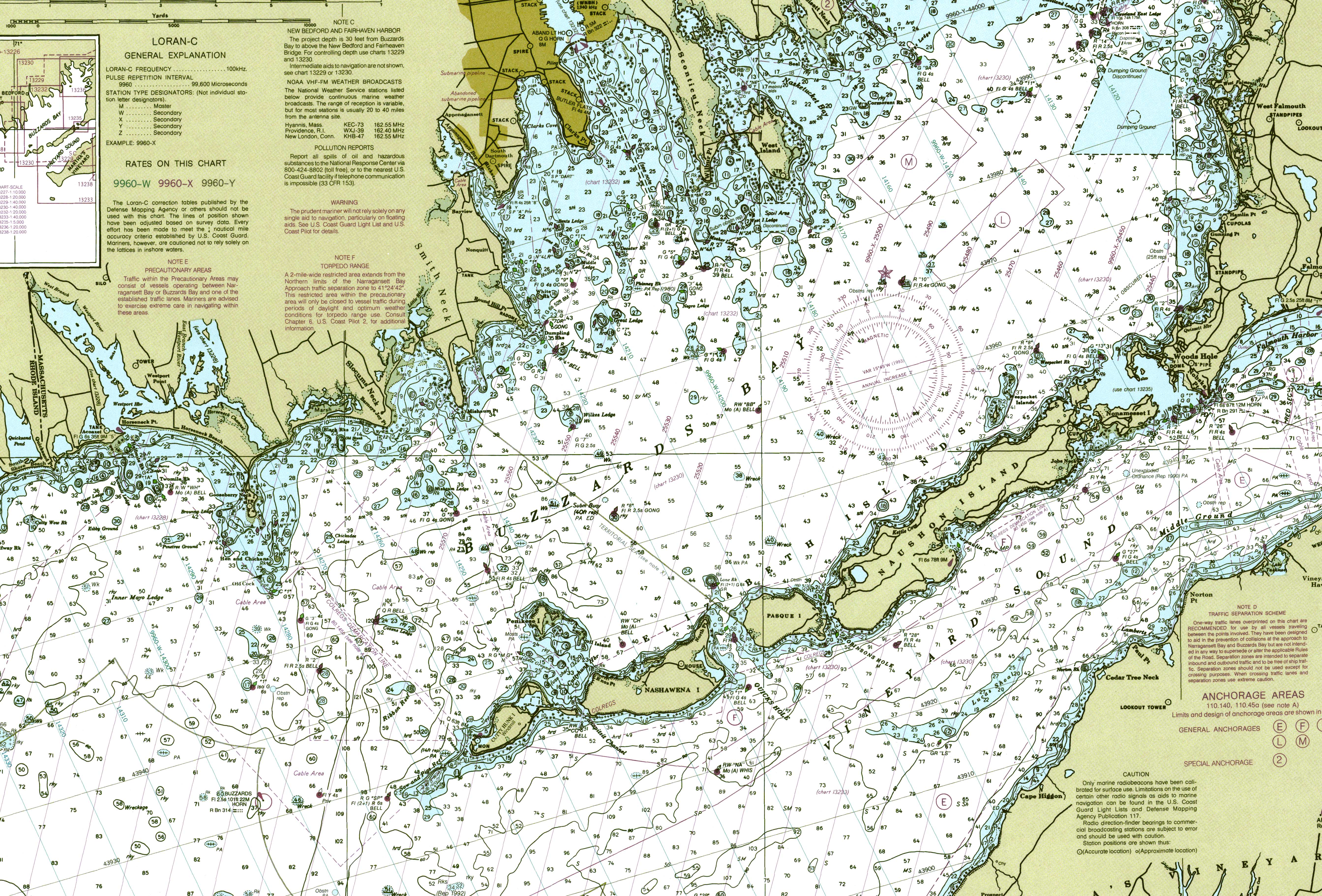
Kanäle mit starken Gezeitenströmungen, hier als holes = Löcher bekannt, trennen die Inseln voneinander und vom Festland. Die Strömungen erreichen Geschwindigkeiten von bis zu 6 Knoten (11 km/h) aufgrund verschiedener Größen und Füllraten des Vineyard Sounds im Südosten und der Buzzard's Bay im Nordwesten. Bei Flut fließt das Wasser von der Buzzards Bay zum Vineyard Sound. Zwischen Ebbe und Flut stoppt das Wasser und macht kehrt und füllt die Bay bei Ebbe.
Von Falmouth aus gesehen aufgelistet sind die benannten Kanäle:
- Woods Hole trennt das Festland von Nonamesset Island
- Robinson Hole zwischen Naushon Island und Pasque Island
- Quick's Hole zwischen Pasque Island und Nashawena Island
- Canapitsit Channel zwischen Nashawena Island und Cuttyhunk
- Cuttyhunk Harbor wird im Osten von Nashawena Island, im Westen von Cuttyhunk und im Norden von Penikese geschützt.
Weblinks
|X|x= |0|-= |S|s= – Sammlung von Bildern |1|= – Sammlung von Bildern{{#if:
| {{#switch: {{#invoke:TemplUtl|faculty|1}}/{{#invoke:TemplUtl|faculty|1}}
|1/= und Videos
|1/1=, Videos und Audiodateien
|/1= und Audiodateien}}
| , Videos und Audiodateien
}}
|#default= – }}{{#if:
| {{#ifeq: {{#invoke:Str|left||9}}
| category:
| FEHLER: Ohne Category: angeben!}}}}Vorlage:Wikidata-Registrierung
- Cuttyhunk Historical Society, das Museum der Elizabeth Islands. Der Vorschlag der Cuttyhunk Historical Society ist die Traditionen, Aufzeichnungen und die Geschichte der Elizabeth Islands als Gewinn für heutige und zukünftige Generationen zu bewahren.
- Seekarte
- Seiten mit defekten Dateilinks
- Wikipedia:Koordinaten-Parameterfehler
- Unbewohnte Inselgruppe
- Wikipedia:Vorlagenfehler/Vorlage:Infobox Insel/Pflichtparameter fehlt
- Wikipedia:Vorlagenfehler/Schwesterprojekt
- Inselgruppe (Massachusetts)
- Inselgruppe (Nordamerika)
- Inselgruppe (Atlantischer Ozean)
- Elizabeth Islands