Calvados-Inseln
| {{#if:|{{{Name}}}|{{#invoke:WLink|getArticleBase}}}} | |||||||||||||||||||||||||||||||||||||||||||||||||||||||||||||||||||||||||||||||||||||||||||||||||||||||||||||||||||||||||||||||||||||||||||||||||||||||||||||||||||||||||||||||||||||||||||||||||||||||||||||||||||||||||||||||||||||||||||||||||||||||||||||||||||||||||||||||||||||||||||||||||||||||||||||||||||||||||||||||||
|---|---|---|---|---|---|---|---|---|---|---|---|---|---|---|---|---|---|---|---|---|---|---|---|---|---|---|---|---|---|---|---|---|---|---|---|---|---|---|---|---|---|---|---|---|---|---|---|---|---|---|---|---|---|---|---|---|---|---|---|---|---|---|---|---|---|---|---|---|---|---|---|---|---|---|---|---|---|---|---|---|---|---|---|---|---|---|---|---|---|---|---|---|---|---|---|---|---|---|---|---|---|---|---|---|---|---|---|---|---|---|---|---|---|---|---|---|---|---|---|---|---|---|---|---|---|---|---|---|---|---|---|---|---|---|---|---|---|---|---|---|---|---|---|---|---|---|---|---|---|---|---|---|---|---|---|---|---|---|---|---|---|---|---|---|---|---|---|---|---|---|---|---|---|---|---|---|---|---|---|---|---|---|---|---|---|---|---|---|---|---|---|---|---|---|---|---|---|---|---|---|---|---|---|---|---|---|---|---|---|---|---|---|---|---|---|---|---|---|---|---|---|---|---|---|---|---|---|---|---|---|---|---|---|---|---|---|---|---|---|---|---|---|---|---|---|---|---|---|---|---|---|---|---|---|---|---|---|---|---|---|---|---|---|---|---|---|---|---|---|---|---|---|---|---|---|---|---|---|---|---|---|---|---|---|---|---|---|---|---|---|---|---|---|---|---|---|---|---|---|---|---|---|---|---|---|---|---|---|---|---|---|---|---|---|---|---|---|---|---|---|---|
}} | |||||||||||||||||||||||||||||||||||||||||||||||||||||||||||||||||||||||||||||||||||||||||||||||||||||||||||||||||||||||||||||||||||||||||||||||||||||||||||||||||||||||||||||||||||||||||||||||||||||||||||||||||||||||||||||||||||||||||||||||||||||||||||||||||||||||||||||||||||||||||||||||||||||||||||||||||||||||||||||||||
| Gewässer | {{#ifexist: Salomonensee|[[Salomonensee]]|Salomonensee}} | {{#if:2019998 | colspan="2" | Pflichtparameter GEWAESSER fehlt }}
}} | ||||||||||||||||||||||||||||||||||||||||||||||||||||||||||||||||||||||||||||||||||||||||||||||||||||||||||||||||||||||||||||||||||||||||||||||||||||||||||||||||||||||||||||||||||||||||||||||||||||||||||||||||||||||||||||||||||||||||||||||||||||||||||||||||||||||||||||||||||||||||||||||||||||||||||||||||||||||||||||||
| Archipel | {{#ifexist: Louisiade-Archipel|[[Louisiade-Archipel]]|Louisiade-Archipel}}
}} | ||||||||||||||||||||||||||||||||||||||||||||||||||||||||||||||||||||||||||||||||||||||||||||||||||||||||||||||||||||||||||||||||||||||||||||||||||||||||||||||||||||||||||||||||||||||||||||||||||||||||||||||||||||||||||||||||||||||||||||||||||||||||||||||||||||||||||||||||||||||||||||||||||||||||||||||||||||||||||||||||
| 1|1}}|{{#switch:{{Info ISO-3166-2:{{#titleparts:PG-MBA|1|1}}|level}} | 1|2={{Info ISO-3166-2:{{#titleparts:PG-MBA|1|1}}|{{#switch:top | 1|1}}|level}} | adm2nd=2 | adm1st=1 | country=0 | #default=top
}} }} |
#default={{#switch: top | continent = | level = | maxlevel = | acronym = | top = ?? | upper = | admtype = | admtypelink = | admname = | lemma = | 0 = | 1 = | 2 = | map = Erde | flag = Flag of None.svg
}} }}}} |
LI|CH|GB={{#switch:{{#if:{{#titleparts:PG-MBA|1|2}}|{{#switch:{{Info ISO-3166-2:{{#titleparts:PG-MBA|1|2}}|level}} | 1|2={{Info ISO-3166-2:{{#titleparts:PG-MBA|1|2}}|{{#switch:top | 1|2}}|level}} | adm2nd=2 | adm1st=1 | country=0 | #default=top
}} }} |
#default={{#switch: top | continent = | level = | maxlevel = | acronym = | top = ?? | upper = | admtype = | admtypelink = | admname = | lemma = | 0 = | 1 = | 2 = | map = Erde | flag = Flag of None.svg
}} }}}} |
LI|CH|GB={{#switch:{{#if:{{#titleparts:PG-MBA|1|3}}|{{#switch:{{Info ISO-3166-2:{{#titleparts:PG-MBA|1|3}}|level}} | 1|2={{Info ISO-3166-2:{{#titleparts:PG-MBA|1|3}}|{{#switch:top | 1|3}}|level}} | adm2nd=2 | adm1st=1 | country=0 | #default=top
}} }} |
#default={{#switch: top | continent = | level = | maxlevel = | acronym = | top = ?? | upper = | admtype = | admtypelink = | admname = | lemma = | 0 = | 1 = | 2 = | map = Erde | flag = Flag of None.svg
}} }}}} |
CH|GB={{#switch:{{#if:{{#titleparts:PG-MBA|1|4}}|{{#switch:{{Info ISO-3166-2:{{#titleparts:PG-MBA|1|4}}|level}} | 1|2={{Info ISO-3166-2:{{#titleparts:PG-MBA|1|4}}|{{#switch:top | 1|4}}|level}} | adm2nd=2 | adm1st=1 | country=0 | #default=top
}} }} |
#default={{#switch: top | continent = | level = | maxlevel = | acronym = | top = ?? | upper = | admtype = | admtypelink = | admname = | lemma = | 0 = | 1 = | 2 = | map = Erde | flag = Flag of None.svg
}} }}}}||LI|CH|GB=|#default=DMS/}} |
#default=DMS/}} | #default=DMS/}} | #default=DMS/}}{{#switch:CH | 1|1}}|{{#switch:{{Info ISO-3166-2:{{#titleparts:PG-MBA|1|1}}|level}} | 1|2={{Info ISO-3166-2:{{#titleparts:PG-MBA|1|1}}|{{#switch:top | 1|1}}|level}} | adm2nd=2 | adm1st=1 | country=0 | #default=top
}} }} |
#default={{#switch: top | continent = | level = | maxlevel = | acronym = | top = ?? | upper = | admtype = | admtypelink = | admname = | lemma = | 0 = | 1 = | 2 = | map = Erde | flag = Flag of None.svg
}} }}}} |
1|2}}|{{#switch:{{Info ISO-3166-2:{{#titleparts:PG-MBA|1|2}}|level}} | 1|2={{Info ISO-3166-2:{{#titleparts:PG-MBA|1|2}}|{{#switch:top | 1|2}}|level}} | adm2nd=2 | adm1st=1 | country=0 | #default=top
}} }} |
#default={{#switch: top | continent = | level = | maxlevel = | acronym = | top = ?? | upper = | admtype = | admtypelink = | admname = | lemma = | 0 = | 1 = | 2 = | map = Erde | flag = Flag of None.svg
}} }}}} |
1|3}}|{{#switch:{{Info ISO-3166-2:{{#titleparts:PG-MBA|1|3}}|level}} | 1|2={{Info ISO-3166-2:{{#titleparts:PG-MBA|1|3}}|{{#switch:top | 1|3}}|level}} | adm2nd=2 | adm1st=1 | country=0 | #default=top
}} }} |
#default={{#switch: top | continent = | level = | maxlevel = | acronym = | top = ?? | upper = | admtype = | admtypelink = | admname = | lemma = | 0 = | 1 = | 2 = | map = Erde | flag = Flag of None.svg
}} }}}} |
1|4}}|{{#switch:{{Info ISO-3166-2:{{#titleparts:PG-MBA|1|4}}|level}} | 1|2={{Info ISO-3166-2:{{#titleparts:PG-MBA|1|4}}|{{#switch:top | 1|4}}|level}} | adm2nd=2 | adm1st=1 | country=0 | #default=top
}} }} |
#default={{#switch: top | continent = | level = | maxlevel = | acronym = | top = ?? | upper = | admtype = | admtypelink = | admname = | lemma = | 0 = | 1 = | 2 = | map = Erde | flag = Flag of None.svg
}} }}}}=CH1903/CH1903 |
#default={{#switch:LI | 1|1}}|{{#switch:{{Info ISO-3166-2:{{#titleparts:PG-MBA|1|1}}|level}} | 1|2={{Info ISO-3166-2:{{#titleparts:PG-MBA|1|1}}|{{#switch:top | 1|1}}|level}} | adm2nd=2 | adm1st=1 | country=0 | #default=top
}} }} |
#default={{#switch: top | continent = | level = | maxlevel = | acronym = | top = ?? | upper = | admtype = | admtypelink = | admname = | lemma = | 0 = | 1 = | 2 = | map = Erde | flag = Flag of None.svg
}} }}}} |
1|2}}|{{#switch:{{Info ISO-3166-2:{{#titleparts:PG-MBA|1|2}}|level}} | 1|2={{Info ISO-3166-2:{{#titleparts:PG-MBA|1|2}}|{{#switch:top | 1|2}}|level}} | adm2nd=2 | adm1st=1 | country=0 | #default=top
}} }} |
#default={{#switch: top | continent = | level = | maxlevel = | acronym = | top = ?? | upper = | admtype = | admtypelink = | admname = | lemma = | 0 = | 1 = | 2 = | map = Erde | flag = Flag of None.svg
}} }}}} |
1|3}}|{{#switch:{{Info ISO-3166-2:{{#titleparts:PG-MBA|1|3}}|level}} | 1|2={{Info ISO-3166-2:{{#titleparts:PG-MBA|1|3}}|{{#switch:top | 1|3}}|level}} | adm2nd=2 | adm1st=1 | country=0 | #default=top
}} }} |
#default={{#switch: top | continent = | level = | maxlevel = | acronym = | top = ?? | upper = | admtype = | admtypelink = | admname = | lemma = | 0 = | 1 = | 2 = | map = Erde | flag = Flag of None.svg
}} }}}} |
1|4}}|{{#switch:{{Info ISO-3166-2:{{#titleparts:PG-MBA|1|4}}|level}} | 1|2={{Info ISO-3166-2:{{#titleparts:PG-MBA|1|4}}|{{#switch:top | 1|4}}|level}} | adm2nd=2 | adm1st=1 | country=0 | #default=top
}} }} |
#default={{#switch: top | continent = | level = | maxlevel = | acronym = | top = ?? | upper = | admtype = | admtypelink = | admname = | lemma = | 0 = | 1 = | 2 = | map = Erde | flag = Flag of None.svg
}} }}}}=CH1903/CH1903 |
#default=DMS/DMS
}}}} |
DMS/CH1903/CH1903={{#if:Geographische Lage|Geographische Lage|Koordinaten}}, (CH) | CH1903/CH1903={{#if:Geographische Lage|Geographische Lage|Koordinaten}} | OSGB36/OSGB36=Ordnance Survey GB | UTM=UTM-Koordinaten | #default={{#if:Geographische Lage|Geographische Lage|Koordinaten}}
}} |
y|Simple|Complex}}|NS=10/43//S|EW=152/22//E|type=isle|region=PG-MBA|globe=|dim=|elevation=|pop=1902|lw=|name={{#invoke:Coordinates/kml|kmlTitle|1={{#if: |{{{Name}}}|{{#invoke:WLink|getArticleBase}}}}}}|article={{#if: | text=/|sortkey=|tooltip=|tooltipformat=|map=|mapsize=|maplevel=|maptype=|maplabel=|maplayer=|mapcaption=}}{{#if:|{{#switch:5 | 1 = Gradzahl-Fehler: {{#iferror:{{{1}}} | NS: {{{1}}} |
}} {{#iferror:
|
EW: |
}}{{#switch:0
|
6|14=
}} |
2 = nicht im Bereich von {{{1}}}{{#switch:0 | 6|14=
}} |
3 = {{#switch: {{{type}}} | state|adm1st|adm2nd|city|isle|airport|mountain|waterbody|forest|landmark= | example={{#if: | falscher Wert ›example‹ im Artikelnamensraum
}} |
kein Wert | falscher Wert ›{{{type}}}‹
}} in type-Parameter{{#switch:0 |
6|14=
}}
}} {{#if: {{{rg}}}
|
region-Parameter fehlt{{#if: |
}}
}} {{#iferror: {{{elevation}}}
|
{{{elevation}}}{{#switch:0 | 6|14=
}} |
}} {{#iferror: {{{pop}}}
|
{{{pop}}}{{#switch:0 | 6|14=
}} |
}} |
, 2:}}{{#if:|, 3:}}{{#if:|, 4:}} {{#if:|usw.}}{{#switch:0 | 6|14=
}} |
8 = Parameter name fehlt in Fließtextkoordinate{{#switch:0 | 6|14=
}} |
10= | #default=coordinates error
}}}} | |||||
| [[Datei:|300px|zentriert|alt=|Karte von {{#if: | Calvados-Inseln}}]] | {{#switch: |none|keine|-= | colspan="2" style="text-align:center; padding:0;" |
{{ Positionskarte {{#if: ||ISO 3166-2 }}
|
1={{#if: | {{#ifeq:/PG-MBA | 1|{{#expr:1+1}}}} | 1|{{#expr:1+1}}}}
}} }} |
label= Calvados-Inseln | {{{Name}}}|{{#invoke:WLink|getArticleBase}}}} | position=none | lat=10/43//S | long=152/22//E | pop=1902 |elevation= |region=PG-MBA | dim= | width=300 | border=none | caption= | marksize=20 | maptype=relief
}} | ||||||||||||||||||||||||||||||||||||||||||||||||||||||||||||||||||||||||||||||||||||||||||||||||||||||||||||||||||||||||||||||||||||||||||||||||||||||||||||||||||||||||||||||||||||||||||||||||||||||||||||||||||||||||||||||||||||||||||||||||||||||||||||||||||||||||||||||||||||||||||||||||||||||||||||||
| Anzahl der Inseln | 45 | {{#if:2019998 | colspan="2" | Pflichtparameter INSELN fehlt }}
}} | ||||||||||||||||||||||||||||||||||||||||||||||||||||||||||||||||||||||||||||||||||||||||||||||||||||||||||||||||||||||||||||||||||||||||||||||||||||||||||||||||||||||||||||||||||||||||||||||||||||||||||||||||||||||||||||||||||||||||||||||||||||||||||||||||||||||||||||||||||||||||||||||||||||||||||||||||||||||||||||||
| Hauptinsel | Pana Wina
}} | ||||||||||||||||||||||||||||||||||||||||||||||||||||||||||||||||||||||||||||||||||||||||||||||||||||||||||||||||||||||||||||||||||||||||||||||||||||||||||||||||||||||||||||||||||||||||||||||||||||||||||||||||||||||||||||||||||||||||||||||||||||||||||||||||||||||||||||||||||||||||||||||||||||||||||||||||||||||||||||||||
| Gesamte Landfläche | Masz}} | {{#if:2019998 | colspan="2" | Pflichtparameter FLAECHE fehlt }}
}} | ||||||||||||||||||||||||||||||||||||||||||||||||||||||||||||||||||||||||||||||||||||||||||||||||||||||||||||||||||||||||||||||||||||||||||||||||||||||||||||||||||||||||||||||||||||||||||||||||||||||||||||||||||||||||||||||||||||||||||||||||||||||||||||||||||||||||||||||||||||||||||||||||||||||||||||||||||||||||||||||
| Einwohner | 0|unbewohnt{{#ifeq: | |}} |Vorlage:FormatNumDef {{#if:2000|(2000)}} }}
}} | ||||||||||||||||||||||||||||||||||||||||||||||||||||||||||||||||||||||||||||||||||||||||||||||||||||||||||||||||||||||||||||||||||||||||||||||||||||||||||||||||||||||||||||||||||||||||||||||||||||||||||||||||||||||||||||||||||||||||||||||||||||||||||||||||||||||||||||||||||||||||||||||||||||||||||||||||||||||||||||||||
}} | |||||||||||||||||||||||||||||||||||||||||||||||||||||||||||||||||||||||||||||||||||||||||||||||||||||||||||||||||||||||||||||||||||||||||||||||||||||||||||||||||||||||||||||||||||||||||||||||||||||||||||||||||||||||||||||||||||||||||||||||||||||||||||||||||||||||||||||||||||||||||||||||||||||||||||||||||||||||||||||||||
{{#if: 10/43//S |{{#if: PG-MBA||
}} {{#switch: |none|keine|-=
}}
}}{{#if: || {{#if: Salomonensee||}} }}{{#if: || {{#if: 81||}} }}{{#if: || {{#if: 45||}} }}
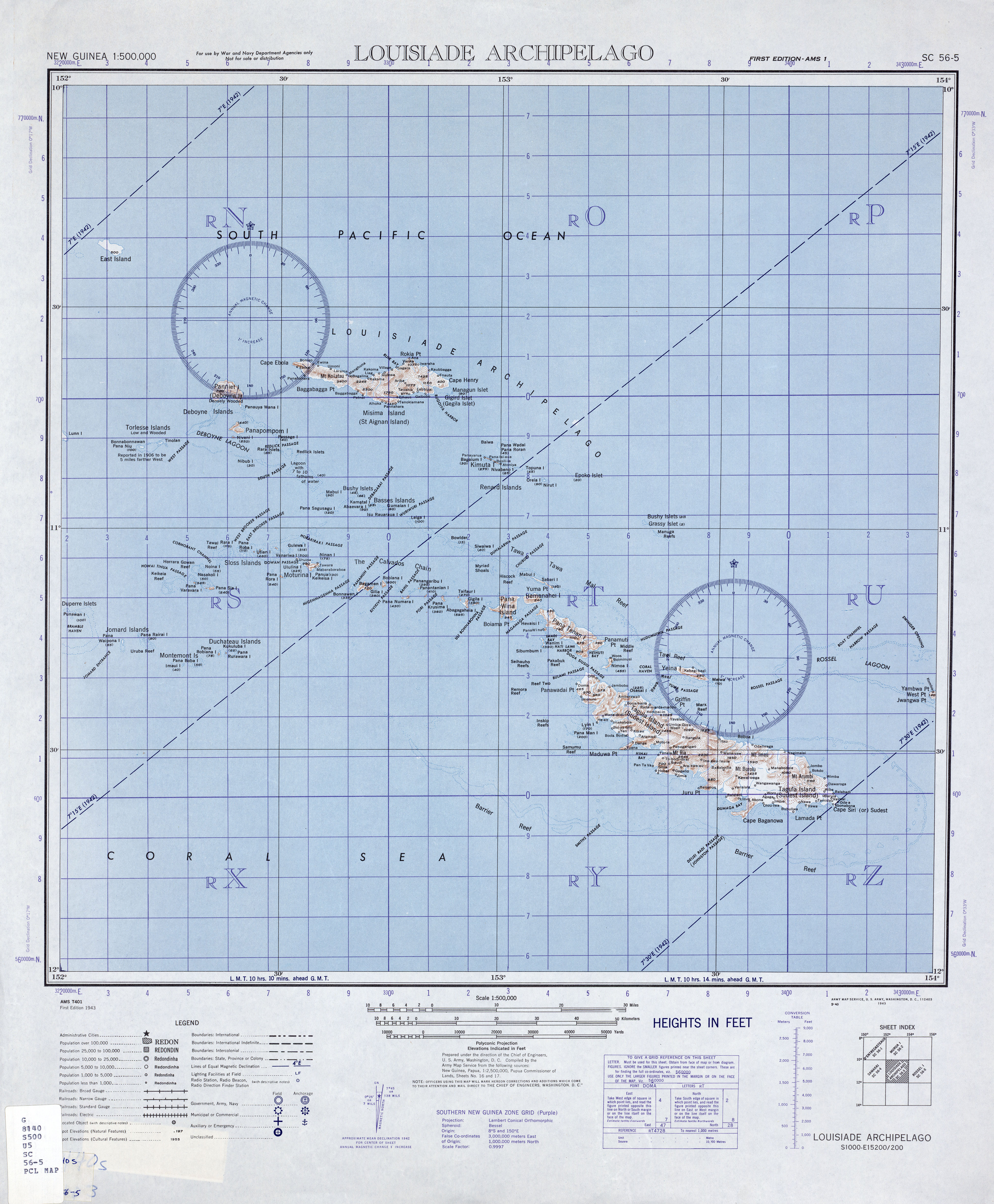
Die Calvados-Inseln sind eine Inselgruppe in der Salomonensee. Politisch gehören sie zur Provinz Milne Bay im südöstlichen Bereich von Papua-Neuguinea. Sie befinden sich innerhalb der Lagune des Vanatinai-Barriereriffs.
Geographie
Allgemein
Die Inselgruppe ist Teil des Louisiade-Archipels. Die Gruppe erstreckt sich von Pana Vara Vara im Westen bis Hemenahei im Osten über eine Distanz von 87 km Luftlinie. Die östlichste Insel Hemenahei ist von der nicht mehr zur Inselkette gerechneten Insel Pana Tinani und der dieser vorgelagerten kleinen Insel Nigao nur durch die an der engsten Stelle nur 890 Meter breite Magamaga Passage getrennt.
Die Inseln steigen bis zu 302 Meter (Motorina) steil aus dem Meer und sind entweder bewaldet oder mit Gras bewachsen. Viele Inseln sind von eigenen Riffen und kleinen Lagunen umgeben. Außer den hohen Inseln gibt es auch zahlreiche flache Koralleninseln und Riffe.
Neun der Inseln sind bewohnt, mit insgesamt 1902 Einwohnern zum Stand der Volkszählung 2000.<ref><templatestyles src="Webarchiv/styles.css" />{{#if:20070609173348
| {{#ifeq: 20070609173348 | *
| {{#if: All 24,390 geocoded census units in PNG from the 2000 census | {{#invoke:WLink|getEscapedTitle|All 24,390 geocoded census units in PNG from the 2000 census}} | {{#invoke:Webarchiv|getdomain|http://coombs.anu.edu.au/SpecialProj/PNG/GMAP/PNG-GMAP.htm}} }} (Archivversionen)
| {{#iferror: {{#time: j. F Y|20070609173348}}
| {{#if: || }}Der Wert des Parameters {{#if: wayback | wayback | Datum }} muss ein gültiger Zeitstempel der Form YYYYMMDDHHMMSS sein!
| {{#if: All 24,390 geocoded census units in PNG from the 2000 census | {{#invoke:WLink|getEscapedTitle|All 24,390 geocoded census units in PNG from the 2000 census}} | {{#invoke:Webarchiv|getdomain|http://coombs.anu.edu.au/SpecialProj/PNG/GMAP/PNG-GMAP.htm}} }} {{#ifeq: | [] | [ | ( }}{{#if: {{#if: | {{{archiv-bot}}} | }} | des Vorlage:Referrer }} vom {{#time: j. F Y|20070609173348}} im Internet Archive{{#if: | ; }}{{#ifeq: | [] | ] | ) }}
}}
}}
| {{#if:
| {{#iferror: {{#time: j. F Y|{{{webciteID}}}}}
| {{#switch: {{#invoke:Str|len|{{{webciteID}}}}}
| 16= {{#if: All 24,390 geocoded census units in PNG from the 2000 census | {{#invoke:WLink|getEscapedTitle|All 24,390 geocoded census units in PNG from the 2000 census}} | {{#invoke:Webarchiv|getdomain|http://coombs.anu.edu.au/SpecialProj/PNG/GMAP/PNG-GMAP.htm}} }} {{#ifeq: | [] | [ | ( }}{{#if: {{#if: | {{{archiv-bot}}} | }} | des Vorlage:Referrer }} vom {{#time: j. F Y| 19700101000000 + {{#expr: floor {{#expr: {{#invoke:Str|sub|{{{webciteID}}}|1|10}}/86400}} }} days}} auf WebCite{{#if: | ; }}{{#ifeq: | [] | ] | ) }}
| 9 = {{#if: All 24,390 geocoded census units in PNG from the 2000 census | {{#invoke:WLink|getEscapedTitle|All 24,390 geocoded census units in PNG from the 2000 census}} | {{#invoke:Webarchiv|getdomain|http://coombs.anu.edu.au/SpecialProj/PNG/GMAP/PNG-GMAP.htm}} }} {{#ifeq: | [] | [ | ( }}{{#if: {{#if: | {{{archiv-bot}}} | }} | des Vorlage:Referrer}} vom {{#time: j. F Y| 19700101000000 + {{#expr: floor {{#expr: {{#invoke:Str|sub|{{#invoke:Expr|base62|{{{webciteID}}}}}|1|10}}/86400}} }} days}} auf WebCite{{#if: | ; }}{{#ifeq: | [] | ] | ) }}
| #default= Der Wert des Parameters {{#if: webciteID | webciteID | ID }} muss entweder ein Zeitstempel der Form YYYYMMDDHHMMSS oder ein Schüsselwert mit 9 Zeichen oder eine 16-stellige Zahl sein!{{#if: || }}
}}
| c|{{{webciteID}}}}} {{#if: All 24,390 geocoded census units in PNG from the 2000 census | {{#invoke:WLink|getEscapedTitle|All 24,390 geocoded census units in PNG from the 2000 census}} | {{#invoke:Webarchiv|getdomain|http://coombs.anu.edu.au/SpecialProj/PNG/GMAP/PNG-GMAP.htm}} }} ({{#if: {{#if: | {{{archiv-bot}}} | }} | des Vorlage:Referrer}} vom {{#time: j. F Y|{{{webciteID}}}}} auf WebCite{{#if: | ; }}{{#ifeq: | [] | ] | ) }}
}}
| {{#if:
| Vorlage:Webarchiv/Today
| {{#if:
| Vorlage:Webarchiv/Generisch
| {{#if: All 24,390 geocoded census units in PNG from the 2000 census | {{#invoke:WLink|getEscapedTitle|All 24,390 geocoded census units in PNG from the 2000 census}} | {{#invoke:Webarchiv|getdomain|http://coombs.anu.edu.au/SpecialProj/PNG/GMAP/PNG-GMAP.htm}} }}
}}}}}}}}{{#if:
| Vorlage:Webarchiv/archiv-bot
}}{{#invoke:TemplatePar|check
|all = url=
|opt = text= wayback= webciteID= archive-is= archive-today= archiv-url= archiv-datum= ()= archiv-bot= format= original=
|cat = Wikipedia:Vorlagenfehler/Vorlage:Webarchiv
|errNS = 0
|template = Vorlage:Webarchiv
|format = *
|preview = 1
}}{{#ifexpr: {{#if:20070609173348|1|0}}{{#if:|+1}}{{#if:|+1}}{{#if:|+1}}{{#if:|+1}} <> 1
| {{#if: || }}{{#invoke:TemplUtl|failure| Fehler bei Vorlage:Webarchiv: Genau einer der Parameter 'wayback', 'webciteID', 'archive-today', 'archive-is' oder 'archiv-url' muss angegeben werden.|1}}
}}{{#if:
| {{#switch: {{#invoke:Webarchiv|getdomain|{{{archiv-url}}}}}
| web.archive.org =
{{#if: || }}{{#invoke:TemplUtl|failure| Fehler bei Vorlage:Webarchiv: Im Parameter 'archiv-url' wurde URL von Internet Archive erkannt, bitte Parameter 'wayback' benutzen.|1}}
| webcitation.org =
{{#if: || }}{{#invoke:TemplUtl|failure| Fehler bei Vorlage:Webarchiv: Im Parameter 'archiv-url' wurde URL von WebCite erkannt, bitte Parameter 'webciteID' benutzen.|1}}
| archive.today |archive.is |archive.ph |archive.fo |archive.li |archive.md |archive.vn =
{{#if: || }}{{#invoke:TemplUtl|failure| Fehler bei Vorlage:Webarchiv: Im Parameter 'archiv-url' wurde URL von archive.today erkannt, bitte Parameter 'archive-today' benutzen.|1}}
}}{{#if:
| {{#iferror: {{#iferror:{{#invoke:Vorlage:FormatDate|Execute}}|}}
| {{#if: || }}{{#invoke:TemplUtl|failure| Fehler bei Vorlage:Webarchiv: Der Wert des Parameter 'archiv-datum' ist ungültig oder hat ein ungültiges Format.|1}}
| }}
| {{#if: || }}{{#invoke:TemplUtl|failure| Fehler bei Vorlage:Webarchiv: Der Pflichtparameter 'archiv-datum' wurde nicht angegeben.|1}}
}}
| {{#if:
| {{#if: || }}{{#invoke:TemplUtl|failure| Fehler bei Vorlage:Webarchiv: Der Parameter 'archiv-datum' ist nur in Verbindung mit 'archiv-url' angebbar.|1}}
}}
}}{{#if:{{#invoke:URLutil|isHostPathResource|http://coombs.anu.edu.au/SpecialProj/PNG/GMAP/PNG-GMAP.htm}}
|| {{#if: || }}
}}{{#if: All 24,390 geocoded census units in PNG from the 2000 census
| {{#if: {{#invoke:WLink|isBracketedLink|All 24,390 geocoded census units in PNG from the 2000 census}}
| {{#if: || }}
}}
| {{#if: || }}
}}{{#switch:
|addlarchives|addlpages= {{#if: || }}{{#if: 1 |}}{{#invoke:TemplUtl|failure| Fehler bei Vorlage:Webarchiv: enWP-Wert im Parameter 'format'.|1}}
}}{{#ifeq: {{#invoke:Str|find|http://coombs.anu.edu.au/SpecialProj/PNG/GMAP/PNG-GMAP.htm%7Carchiv}} |-1
|| {{#ifeq: {{#invoke:Str|find|{{#invoke:Str|cropleft|http://coombs.anu.edu.au/SpecialProj/PNG/GMAP/PNG-GMAP.htm%7C4}}%7Chttp}} |-1
|| {{#switch: {{#invoke:Webarchiv|getdomain|http://coombs.anu.edu.au/SpecialProj/PNG/GMAP/PNG-GMAP.htm }}
| abendblatt.de | daserste.ndr.de | inarchive.com | webcitation.org =
| #default = {{#if: || }}{{#if: 1 |}}{{#invoke:TemplUtl|failure| Fehler bei Vorlage:Webarchiv: Archiv-URL im Parameter 'url' anstatt URL der Originalquelle. Entferne den vor der Original-URL stehenden Mementobestandteil und setze den Archivierungszeitstempel in den Parameter 'wayback', 'webciteID', 'archive.today' oder 'archive-is' ein, sofern nicht bereits befüllt.|1}}
}}
}}
}}</ref> Die Sprache ist Misima-Paneati.<ref>M. Paul Lewis (Hrsg.) Misima-Paneati, A language of Papua New Guinea Ethnologue: Languages of the World, SIL International, Dallas 2009.</ref>
Inselliste
Diese Tabelle listet die Calvados-Inseln von West nach Ost auf:<ref>Arthur Wichman (Hrsg.): Entdeckungsgeschichte von Neu-Guinea (bis 1828). Band 1. E. J. Brill, Leiden 1909, S. 72; books.google.de</ref>
| Inselname | Aliasname | Koordinaten | Fläche km² |
Einwohner 2000 | |||||||||||||||||||||||||||||||||
|---|---|---|---|---|---|---|---|---|---|---|---|---|---|---|---|---|---|---|---|---|---|---|---|---|---|---|---|---|---|---|---|---|---|---|---|---|---|
| Pana Vara Vara | Rugged Island | y|Simple|Complex}}|NS=11/07/14/S|EW=152/18/09/E|type=isle|region=PG-MBA|globe=|dim=|elevation=|pop=|lw=|name={{#invoke:Coordinates/kml|kmlTitle|1=Pana Vara Vara}}|article=|text=DMS|sortkey=NS|tooltip=|tooltipformat=|map=|mapsize=|maplevel=|maptype=|maplabel=|maplayer=|mapcaption=}}{{#if:|{{#switch:5 | 1 = Gradzahl-Fehler: {{#iferror:{{{1}}} | NS: {{{1}}} |
}} {{#iferror:
|
EW: |
}}{{#switch:0
|
6|14=
}} |
2 = nicht im Bereich von {{{1}}}{{#switch:0 | 6|14=
}} |
3 = {{#switch: {{{type}}} | state|adm1st|adm2nd|city|isle|airport|mountain|waterbody|forest|landmark= | example={{#if: | falscher Wert ›example‹ im Artikelnamensraum
}} |
kein Wert | falscher Wert ›{{{type}}}‹
}} in type-Parameter{{#switch:0 |
6|14=
}}
}} {{#if: {{{rg}}}
|
region-Parameter fehlt{{#if: |
}}
}} {{#iferror: {{{elevation}}}
|
{{{elevation}}}{{#switch:0 | 6|14=
}} |
}} {{#iferror: {{{pop}}}
|
{{{pop}}}{{#switch:0 | 6|14=
}} |
}} |
, 2:}}{{#if:|, 3:}}{{#if:|, 4:}} {{#if:|usw.}}{{#switch:0 | 6|14=
}} |
8 = Parameter name fehlt in Fließtextkoordinate{{#switch:0 | 6|14=
}} |
10= | #default=coordinates error
}}}} |
0,57 | – | ||||
| Ehiki | y|Simple|Complex}}|NS=11/04/56/S|EW=152/18/45/E|type=isle|region=PG-MBA|globe=|dim=|elevation=|pop=|lw=|name={{#invoke:Coordinates/kml|kmlTitle|1=Ehiki}}|article=|text=DMS|sortkey=NS|tooltip=|tooltipformat=|map=|mapsize=|maplevel=|maptype=|maplabel=|maplayer=|mapcaption=}}{{#if:|{{#switch:5 | 1 = Gradzahl-Fehler: {{#iferror:{{{1}}} | NS: {{{1}}} |
}} {{#iferror:
|
EW: |
}}{{#switch:0
|
6|14=
}} |
2 = nicht im Bereich von {{{1}}}{{#switch:0 | 6|14=
}} |
3 = {{#switch: {{{type}}} | state|adm1st|adm2nd|city|isle|airport|mountain|waterbody|forest|landmark= | example={{#if: | falscher Wert ›example‹ im Artikelnamensraum
}} |
kein Wert | falscher Wert ›{{{type}}}‹
}} in type-Parameter{{#switch:0 |
6|14=
}}
}} {{#if: {{{rg}}}
|
region-Parameter fehlt{{#if: |
}}
}} {{#iferror: {{{elevation}}}
|
{{{elevation}}}{{#switch:0 | 6|14=
}} |
}} {{#iferror: {{{pop}}}
|
{{{pop}}}{{#switch:0 | 6|14=
}} |
}} |
, 2:}}{{#if:|, 3:}}{{#if:|, 4:}} {{#if:|usw.}}{{#switch:0 | 6|14=
}} |
8 = Parameter name fehlt in Fließtextkoordinate{{#switch:0 | 6|14=
}} |
10= | #default=coordinates error
}}}} |
0,05 | – | |||||
| Nasakoli | y|Simple|Complex}}|NS=11/06/42/S|EW=152/18/55/E|type=isle|region=PG-MBA|globe=|dim=|elevation=|pop=|lw=|name={{#invoke:Coordinates/kml|kmlTitle|1=Nasakoli}}|article=|text=DMS|sortkey=NS|tooltip=|tooltipformat=|map=|mapsize=|maplevel=|maptype=|maplabel=|maplayer=|mapcaption=}}{{#if:|{{#switch:5 | 1 = Gradzahl-Fehler: {{#iferror:{{{1}}} | NS: {{{1}}} |
}} {{#iferror:
|
EW: |
}}{{#switch:0
|
6|14=
}} |
2 = nicht im Bereich von {{{1}}}{{#switch:0 | 6|14=
}} |
3 = {{#switch: {{{type}}} | state|adm1st|adm2nd|city|isle|airport|mountain|waterbody|forest|landmark= | example={{#if: | falscher Wert ›example‹ im Artikelnamensraum
}} |
kein Wert | falscher Wert ›{{{type}}}‹
}} in type-Parameter{{#switch:0 |
6|14=
}}
}} {{#if: {{{rg}}}
|
region-Parameter fehlt{{#if: |
}}
}} {{#iferror: {{{elevation}}}
|
{{{elevation}}}{{#switch:0 | 6|14=
}} |
}} {{#iferror: {{{pop}}}
|
{{{pop}}}{{#switch:0 | 6|14=
}} |
}} |
, 2:}}{{#if:|, 3:}}{{#if:|, 4:}} {{#if:|usw.}}{{#switch:0 | 6|14=
}} |
8 = Parameter name fehlt in Fließtextkoordinate{{#switch:0 | 6|14=
}} |
10= | #default=coordinates error
}}}} |
0,01 | – | |||||
| Panasia | Real Island | y|Simple|Complex}}|NS=11/08/00/S|EW=152/19/58/E|type=isle|region=PG-MBA|globe=|dim=|elevation=|pop=|lw=|name={{#invoke:Coordinates/kml|kmlTitle|1=Panasia}}|article=|text=DMS|sortkey=NS|tooltip=|tooltipformat=|map=|mapsize=|maplevel=|maptype=|maplabel=|maplayer=|mapcaption=}}{{#if:|{{#switch:5 | 1 = Gradzahl-Fehler: {{#iferror:{{{1}}} | NS: {{{1}}} |
}} {{#iferror:
|
EW: |
}}{{#switch:0
|
6|14=
}} |
2 = nicht im Bereich von {{{1}}}{{#switch:0 | 6|14=
}} |
3 = {{#switch: {{{type}}} | state|adm1st|adm2nd|city|isle|airport|mountain|waterbody|forest|landmark= | example={{#if: | falscher Wert ›example‹ im Artikelnamensraum
}} |
kein Wert | falscher Wert ›{{{type}}}‹
}} in type-Parameter{{#switch:0 |
6|14=
}}
}} {{#if: {{{rg}}}
|
region-Parameter fehlt{{#if: |
}}
}} {{#iferror: {{{elevation}}}
|
{{{elevation}}}{{#switch:0 | 6|14=
}} |
}} {{#iferror: {{{pop}}}
|
{{{pop}}}{{#switch:0 | 6|14=
}} |
}} |
, 2:}}{{#if:|, 3:}}{{#if:|, 4:}} {{#if:|usw.}}{{#switch:0 | 6|14=
}} |
8 = Parameter name fehlt in Fließtextkoordinate{{#switch:0 | 6|14=
}} |
10= | #default=coordinates error
}}}} |
2,11 | – | ||||
| No Ina | Burnett Island | y|Simple|Complex}}|NS=11/04/47/S|EW=152/21/19/E|type=isle|region=PG-MBA|globe=|dim=|elevation=|pop=|lw=|name={{#invoke:Coordinates/kml|kmlTitle|1=No Ina}}|article=|text=DMS|sortkey=NS|tooltip=|tooltipformat=|map=|mapsize=|maplevel=|maptype=|maplabel=|maplayer=|mapcaption=}}{{#if:|{{#switch:5 | 1 = Gradzahl-Fehler: {{#iferror:{{{1}}} | NS: {{{1}}} |
}} {{#iferror:
|
EW: |
}}{{#switch:0
|
6|14=
}} |
2 = nicht im Bereich von {{{1}}}{{#switch:0 | 6|14=
}} |
3 = {{#switch: {{{type}}} | state|adm1st|adm2nd|city|isle|airport|mountain|waterbody|forest|landmark= | example={{#if: | falscher Wert ›example‹ im Artikelnamensraum
}} |
kein Wert | falscher Wert ›{{{type}}}‹
}} in type-Parameter{{#switch:0 |
6|14=
}}
}} {{#if: {{{rg}}}
|
region-Parameter fehlt{{#if: |
}}
}} {{#iferror: {{{elevation}}}
|
{{{elevation}}}{{#switch:0 | 6|14=
}} |
}} {{#iferror: {{{pop}}}
|
{{{pop}}}{{#switch:0 | 6|14=
}} |
}} |
, 2:}}{{#if:|, 3:}}{{#if:|, 4:}} {{#if:|usw.}}{{#switch:0 | 6|14=
}} |
8 = Parameter name fehlt in Fließtextkoordinate{{#switch:0 | 6|14=
}} |
10= | #default=coordinates error
}}}} |
0,13 | – | ||||
| Rara | y|Simple|Complex}}|NS=11/02/23/S|EW=152/22/59/E|type=isle|region=PG-MBA|globe=|dim=|elevation=|pop=|lw=|name={{#invoke:Coordinates/kml|kmlTitle|1=Rara}}|article=|text=DMS|sortkey=NS|tooltip=|tooltipformat=|map=|mapsize=|maplevel=|maptype=|maplabel=|maplayer=|mapcaption=}}{{#if:|{{#switch:5 | 1 = Gradzahl-Fehler: {{#iferror:{{{1}}} | NS: {{{1}}} |
}} {{#iferror:
|
EW: |
}}{{#switch:0
|
6|14=
}} |
2 = nicht im Bereich von {{{1}}}{{#switch:0 | 6|14=
}} |
3 = {{#switch: {{{type}}} | state|adm1st|adm2nd|city|isle|airport|mountain|waterbody|forest|landmark= | example={{#if: | falscher Wert ›example‹ im Artikelnamensraum
}} |
kein Wert | falscher Wert ›{{{type}}}‹
}} in type-Parameter{{#switch:0 |
6|14=
}}
}} {{#if: {{{rg}}}
|
region-Parameter fehlt{{#if: |
}}
}} {{#iferror: {{{elevation}}}
|
{{{elevation}}}{{#switch:0 | 6|14=
}} |
}} {{#iferror: {{{pop}}}
|
{{{pop}}}{{#switch:0 | 6|14=
}} |
}} |
, 2:}}{{#if:|, 3:}}{{#if:|, 4:}} {{#if:|usw.}}{{#switch:0 | 6|14=
}} |
8 = Parameter name fehlt in Fließtextkoordinate{{#switch:0 | 6|14=
}} |
10= | #default=coordinates error
}}}} |
0,17 | – | |||||
| Pana Roba | Sloss Island | y|Simple|Complex}}|NS=11/02/31/S|EW=152/24/08/E|type=isle|region=PG-MBA|globe=|dim=|elevation=|pop=|lw=|name={{#invoke:Coordinates/kml|kmlTitle|1=Pana Roba}}|article=|text=DMS|sortkey=NS|tooltip=|tooltipformat=|map=|mapsize=|maplevel=|maptype=|maplabel=|maplayer=|mapcaption=}}{{#if:|{{#switch:5 | 1 = Gradzahl-Fehler: {{#iferror:{{{1}}} | NS: {{{1}}} |
}} {{#iferror:
|
EW: |
}}{{#switch:0
|
6|14=
}} |
2 = nicht im Bereich von {{{1}}}{{#switch:0 | 6|14=
}} |
3 = {{#switch: {{{type}}} | state|adm1st|adm2nd|city|isle|airport|mountain|waterbody|forest|landmark= | example={{#if: | falscher Wert ›example‹ im Artikelnamensraum
}} |
kein Wert | falscher Wert ›{{{type}}}‹
}} in type-Parameter{{#switch:0 |
6|14=
}}
}} {{#if: {{{rg}}}
|
region-Parameter fehlt{{#if: |
}}
}} {{#iferror: {{{elevation}}}
|
{{{elevation}}}{{#switch:0 | 6|14=
}} |
}} {{#iferror: {{{pop}}}
|
{{{pop}}}{{#switch:0 | 6|14=
}} |
}} |
, 2:}}{{#if:|, 3:}}{{#if:|, 4:}} {{#if:|usw.}}{{#switch:0 | 6|14=
}} |
8 = Parameter name fehlt in Fließtextkoordinate{{#switch:0 | 6|14=
}} |
10= | #default=coordinates error
}}}} |
0,19 | – | ||||
| Utian | Brooker Island | y|Simple|Complex}}|NS=11/03/00/S|EW=152/26/48/E|type=isle|region=PG-MBA|globe=|dim=|elevation=|pop=|lw=|name={{#invoke:Coordinates/kml|kmlTitle|1=Utian}}|article=|text=DMS|sortkey=NS|tooltip=|tooltipformat=|map=|mapsize=|maplevel=|maptype=|maplabel=|maplayer=|mapcaption=}}{{#if:|{{#switch:5 | 1 = Gradzahl-Fehler: {{#iferror:{{{1}}} | NS: {{{1}}} |
}} {{#iferror:
|
EW: |
}}{{#switch:0
|
6|14=
}} |
2 = nicht im Bereich von {{{1}}}{{#switch:0 | 6|14=
}} |
3 = {{#switch: {{{type}}} | state|adm1st|adm2nd|city|isle|airport|mountain|waterbody|forest|landmark= | example={{#if: | falscher Wert ›example‹ im Artikelnamensraum
}} |
kein Wert | falscher Wert ›{{{type}}}‹
}} in type-Parameter{{#switch:0 |
6|14=
}}
}} {{#if: {{{rg}}}
|
region-Parameter fehlt{{#if: |
}}
}} {{#iferror: {{{elevation}}}
|
{{{elevation}}}{{#switch:0 | 6|14=
}} |
}} {{#iferror: {{{pop}}}
|
{{{pop}}}{{#switch:0 | 6|14=
}} |
}} |
, 2:}}{{#if:|, 3:}}{{#if:|, 4:}} {{#if:|usw.}}{{#switch:0 | 6|14=
}} |
8 = Parameter name fehlt in Fließtextkoordinate{{#switch:0 | 6|14=
}} |
10= | #default=coordinates error
}}}} |
1,54 | 391 | ||||
| Pana Udu Udi | y|Simple|Complex}}|NS=11/02/38/S|EW=152/29/11/E|type=isle|region=PG-MBA|globe=|dim=|elevation=|pop=|lw=|name={{#invoke:Coordinates/kml|kmlTitle|1=Pana Udu Udi}}|article=|text=DMS|sortkey=NS|tooltip=|tooltipformat=|map=|mapsize=|maplevel=|maptype=|maplabel=|maplayer=|mapcaption=}}{{#if:|{{#switch:5 | 1 = Gradzahl-Fehler: {{#iferror:{{{1}}} | NS: {{{1}}} |
}} {{#iferror:
|
EW: |
}}{{#switch:0
|
6|14=
}} |
2 = nicht im Bereich von {{{1}}}{{#switch:0 | 6|14=
}} |
3 = {{#switch: {{{type}}} | state|adm1st|adm2nd|city|isle|airport|mountain|waterbody|forest|landmark= | example={{#if: | falscher Wert ›example‹ im Artikelnamensraum
}} |
kein Wert | falscher Wert ›{{{type}}}‹
}} in type-Parameter{{#switch:0 |
6|14=
}}
}} {{#if: {{{rg}}}
|
region-Parameter fehlt{{#if: |
}}
}} {{#iferror: {{{elevation}}}
|
{{{elevation}}}{{#switch:0 | 6|14=
}} |
}} {{#iferror: {{{pop}}}
|
{{{pop}}}{{#switch:0 | 6|14=
}} |
}} |
, 2:}}{{#if:|, 3:}}{{#if:|, 4:}} {{#if:|usw.}}{{#switch:0 | 6|14=
}} |
8 = Parameter name fehlt in Fließtextkoordinate{{#switch:0 | 6|14=
}} |
10= | #default=coordinates error
}}}} |
0,69 | – | |||||
| Pana Rora | Eddystone Island | y|Simple|Complex}}|NS=11/06/30/S|EW=152/30/03/E|type=isle|region=PG-MBA|globe=|dim=|elevation=|pop=|lw=|name={{#invoke:Coordinates/kml|kmlTitle|1=Pana Rora}}|article=|text=DMS|sortkey=NS|tooltip=|tooltipformat=|map=|mapsize=|maplevel=|maptype=|maplabel=|maplayer=|mapcaption=}}{{#if:|{{#switch:5 | 1 = Gradzahl-Fehler: {{#iferror:{{{1}}} | NS: {{{1}}} |
}} {{#iferror:
|
EW: |
}}{{#switch:0
|
6|14=
}} |
2 = nicht im Bereich von {{{1}}}{{#switch:0 | 6|14=
}} |
3 = {{#switch: {{{type}}} | state|adm1st|adm2nd|city|isle|airport|mountain|waterbody|forest|landmark= | example={{#if: | falscher Wert ›example‹ im Artikelnamensraum
}} |
kein Wert | falscher Wert ›{{{type}}}‹
}} in type-Parameter{{#switch:0 |
6|14=
}}
}} {{#if: {{{rg}}}
|
region-Parameter fehlt{{#if: |
}}
}} {{#iferror: {{{elevation}}}
|
{{{elevation}}}{{#switch:0 | 6|14=
}} |
}} {{#iferror: {{{pop}}}
|
{{{pop}}}{{#switch:0 | 6|14=
}} |
}} |
, 2:}}{{#if:|, 3:}}{{#if:|, 4:}} {{#if:|usw.}}{{#switch:0 | 6|14=
}} |
8 = Parameter name fehlt in Fließtextkoordinate{{#switch:0 | 6|14=
}} |
10= | #default=coordinates error
}}}} |
0,81 | – | ||||
| Toloi Awa | y|Simple|Complex}}|NS=11/02/58/S|EW=152/29/52/E|type=isle|region=PG-MBA|globe=|dim=|elevation=|pop=|lw=|name={{#invoke:Coordinates/kml|kmlTitle|1=Toloi Awa}}|article=|text=DMS|sortkey=NS|tooltip=|tooltipformat=|map=|mapsize=|maplevel=|maptype=|maplabel=|maplayer=|mapcaption=}}{{#if:|{{#switch:5 | 1 = Gradzahl-Fehler: {{#iferror:{{{1}}} | NS: {{{1}}} |
}} {{#iferror:
|
EW: |
}}{{#switch:0
|
6|14=
}} |
2 = nicht im Bereich von {{{1}}}{{#switch:0 | 6|14=
}} |
3 = {{#switch: {{{type}}} | state|adm1st|adm2nd|city|isle|airport|mountain|waterbody|forest|landmark= | example={{#if: | falscher Wert ›example‹ im Artikelnamensraum
}} |
kein Wert | falscher Wert ›{{{type}}}‹
}} in type-Parameter{{#switch:0 |
6|14=
}}
}} {{#if: {{{rg}}}
|
region-Parameter fehlt{{#if: |
}}
}} {{#iferror: {{{elevation}}}
|
{{{elevation}}}{{#switch:0 | 6|14=
}} |
}} {{#iferror: {{{pop}}}
|
{{{pop}}}{{#switch:0 | 6|14=
}} |
}} |
, 2:}}{{#if:|, 3:}}{{#if:|, 4:}} {{#if:|usw.}}{{#switch:0 | 6|14=
}} |
8 = Parameter name fehlt in Fließtextkoordinate{{#switch:0 | 6|14=
}} |
10= | #default=coordinates error
}}}} |
0,13 | – | |||||
| Gulewa | y|Simple|Complex}}|NS=11/02/31/S|EW=152/30/48/E|type=isle|region=PG-MBA|globe=|dim=|elevation=|pop=|lw=|name={{#invoke:Coordinates/kml|kmlTitle|1=Gulewa}}|article=|text=DMS|sortkey=NS|tooltip=|tooltipformat=|map=|mapsize=|maplevel=|maptype=|maplabel=|maplayer=|mapcaption=}}{{#if:|{{#switch:5 | 1 = Gradzahl-Fehler: {{#iferror:{{{1}}} | NS: {{{1}}} |
}} {{#iferror:
|
EW: |
}}{{#switch:0
|
6|14=
}} |
2 = nicht im Bereich von {{{1}}}{{#switch:0 | 6|14=
}} |
3 = {{#switch: {{{type}}} | state|adm1st|adm2nd|city|isle|airport|mountain|waterbody|forest|landmark= | example={{#if: | falscher Wert ›example‹ im Artikelnamensraum
}} |
kein Wert | falscher Wert ›{{{type}}}‹
}} in type-Parameter{{#switch:0 |
6|14=
}}
}} {{#if: {{{rg}}}
|
region-Parameter fehlt{{#if: |
}}
}} {{#iferror: {{{elevation}}}
|
{{{elevation}}}{{#switch:0 | 6|14=
}} |
}} {{#iferror: {{{pop}}}
|
{{{pop}}}{{#switch:0 | 6|14=
}} |
}} |
, 2:}}{{#if:|, 3:}}{{#if:|, 4:}} {{#if:|usw.}}{{#switch:0 | 6|14=
}} |
8 = Parameter name fehlt in Fließtextkoordinate{{#switch:0 | 6|14=
}} |
10= | #default=coordinates error
}}}} |
0,59 | 14 | |||||
| Sibumbum | y|Simple|Complex}}|NS=11/01/43/S|EW=152/31/08/E|type=isle|region=PG-MBA|globe=|dim=|elevation=|pop=|lw=|name={{#invoke:Coordinates/kml|kmlTitle|1=Sibumbum}}|article=|text=DMS|sortkey=NS|tooltip=|tooltipformat=|map=|mapsize=|maplevel=|maptype=|maplabel=|maplayer=|mapcaption=}}{{#if:|{{#switch:5 | 1 = Gradzahl-Fehler: {{#iferror:{{{1}}} | NS: {{{1}}} |
}} {{#iferror:
|
EW: |
}}{{#switch:0
|
6|14=
}} |
2 = nicht im Bereich von {{{1}}}{{#switch:0 | 6|14=
}} |
3 = {{#switch: {{{type}}} | state|adm1st|adm2nd|city|isle|airport|mountain|waterbody|forest|landmark= | example={{#if: | falscher Wert ›example‹ im Artikelnamensraum
}} |
kein Wert | falscher Wert ›{{{type}}}‹
}} in type-Parameter{{#switch:0 |
6|14=
}}
}} {{#if: {{{rg}}}
|
region-Parameter fehlt{{#if: |
}}
}} {{#iferror: {{{elevation}}}
|
{{{elevation}}}{{#switch:0 | 6|14=
}} |
}} {{#iferror: {{{pop}}}
|
{{{pop}}}{{#switch:0 | 6|14=
}} |
}} |
, 2:}}{{#if:|, 3:}}{{#if:|, 4:}} {{#if:|usw.}}{{#switch:0 | 6|14=
}} |
8 = Parameter name fehlt in Fließtextkoordinate{{#switch:0 | 6|14=
}} |
10= | #default=coordinates error
}}}} |
0,01 | – | |||||
| Tobaiam | y|Simple|Complex}}|NS=11/03/07/S|EW=152/30/57/E|type=isle|region=PG-MBA|globe=|dim=|elevation=|pop=|lw=|name={{#invoke:Coordinates/kml|kmlTitle|1=Tobaiam}}|article=|text=DMS|sortkey=NS|tooltip=|tooltipformat=|map=|mapsize=|maplevel=|maptype=|maplabel=|maplayer=|mapcaption=}}{{#if:|{{#switch:5 | 1 = Gradzahl-Fehler: {{#iferror:{{{1}}} | NS: {{{1}}} |
}} {{#iferror:
|
EW: |
}}{{#switch:0
|
6|14=
}} |
2 = nicht im Bereich von {{{1}}}{{#switch:0 | 6|14=
}} |
3 = {{#switch: {{{type}}} | state|adm1st|adm2nd|city|isle|airport|mountain|waterbody|forest|landmark= | example={{#if: | falscher Wert ›example‹ im Artikelnamensraum
}} |
kein Wert | falscher Wert ›{{{type}}}‹
}} in type-Parameter{{#switch:0 |
6|14=
}}
}} {{#if: {{{rg}}}
|
region-Parameter fehlt{{#if: |
}}
}} {{#iferror: {{{elevation}}}
|
{{{elevation}}}{{#switch:0 | 6|14=
}} |
}} {{#iferror: {{{pop}}}
|
{{{pop}}}{{#switch:0 | 6|14=
}} |
}} |
, 2:}}{{#if:|, 3:}}{{#if:|, 4:}} {{#if:|usw.}}{{#switch:0 | 6|14=
}} |
8 = Parameter name fehlt in Fließtextkoordinate{{#switch:0 | 6|14=
}} |
10= | #default=coordinates error
}}}} |
0,07 | – | |||||
| Ululina | y|Simple|Complex}}|NS=11/04/54/S|EW=152/32/18/E|type=isle|region=PG-MBA|globe=|dim=|elevation=|pop=|lw=|name={{#invoke:Coordinates/kml|kmlTitle|1=Ululina}}|article=|text=DMS|sortkey=NS|tooltip=|tooltipformat=|map=|mapsize=|maplevel=|maptype=|maplabel=|maplayer=|mapcaption=}}{{#if:|{{#switch:5 | 1 = Gradzahl-Fehler: {{#iferror:{{{1}}} | NS: {{{1}}} |
}} {{#iferror:
|
EW: |
}}{{#switch:0
|
6|14=
}} |
2 = nicht im Bereich von {{{1}}}{{#switch:0 | 6|14=
}} |
3 = {{#switch: {{{type}}} | state|adm1st|adm2nd|city|isle|airport|mountain|waterbody|forest|landmark= | example={{#if: | falscher Wert ›example‹ im Artikelnamensraum
}} |
kein Wert | falscher Wert ›{{{type}}}‹
}} in type-Parameter{{#switch:0 |
6|14=
}}
}} {{#if: {{{rg}}}
|
region-Parameter fehlt{{#if: |
}}
}} {{#iferror: {{{elevation}}}
|
{{{elevation}}}{{#switch:0 | 6|14=
}} |
}} {{#iferror: {{{pop}}}
|
{{{pop}}}{{#switch:0 | 6|14=
}} |
}} |
, 2:}}{{#if:|, 3:}}{{#if:|, 4:}} {{#if:|usw.}}{{#switch:0 | 6|14=
}} |
8 = Parameter name fehlt in Fließtextkoordinate{{#switch:0 | 6|14=
}} |
10= | #default=coordinates error
}}}} |
0,59 | – | |||||
| Venariwa | Vanaliwa | y|Simple|Complex}}|NS=11/04/00/S|EW=152/32/01/E|type=isle|region=PG-MBA|globe=|dim=|elevation=|pop=|lw=|name={{#invoke:Coordinates/kml|kmlTitle|1=Venariwa}}|article=|text=DMS|sortkey=NS|tooltip=|tooltipformat=|map=|mapsize=|maplevel=|maptype=|maplabel=|maplayer=|mapcaption=}}{{#if:|{{#switch:5 | 1 = Gradzahl-Fehler: {{#iferror:{{{1}}} | NS: {{{1}}} |
}} {{#iferror:
|
EW: |
}}{{#switch:0
|
6|14=
}} |
2 = nicht im Bereich von {{{1}}}{{#switch:0 | 6|14=
}} |
3 = {{#switch: {{{type}}} | state|adm1st|adm2nd|city|isle|airport|mountain|waterbody|forest|landmark= | example={{#if: | falscher Wert ›example‹ im Artikelnamensraum
}} |
kein Wert | falscher Wert ›{{{type}}}‹
}} in type-Parameter{{#switch:0 |
6|14=
}}
}} {{#if: {{{rg}}}
|
region-Parameter fehlt{{#if: |
}}
}} {{#iferror: {{{elevation}}}
|
{{{elevation}}}{{#switch:0 | 6|14=
}} |
}} {{#iferror: {{{pop}}}
|
{{{pop}}}{{#switch:0 | 6|14=
}} |
}} |
, 2:}}{{#if:|, 3:}}{{#if:|, 4:}} {{#if:|usw.}}{{#switch:0 | 6|14=
}} |
8 = Parameter name fehlt in Fließtextkoordinate{{#switch:0 | 6|14=
}} |
10= | #default=coordinates error
}}}} |
0,76 | 12 | ||||
| Saru Nom Nom | y|Simple|Complex}}|NS=11/02/00/S|EW=152/32/46/E|type=isle|region=PG-MBA|globe=|dim=|elevation=|pop=|lw=|name={{#invoke:Coordinates/kml|kmlTitle|1=Saru Nom Nom}}|article=|text=DMS|sortkey=NS|tooltip=|tooltipformat=|map=|mapsize=|maplevel=|maptype=|maplabel=|maplayer=|mapcaption=}}{{#if:|{{#switch:5 | 1 = Gradzahl-Fehler: {{#iferror:{{{1}}} | NS: {{{1}}} |
}} {{#iferror:
|
EW: |
}}{{#switch:0
|
6|14=
}} |
2 = nicht im Bereich von {{{1}}}{{#switch:0 | 6|14=
}} |
3 = {{#switch: {{{type}}} | state|adm1st|adm2nd|city|isle|airport|mountain|waterbody|forest|landmark= | example={{#if: | falscher Wert ›example‹ im Artikelnamensraum
}} |
kein Wert | falscher Wert ›{{{type}}}‹
}} in type-Parameter{{#switch:0 |
6|14=
}}
}} {{#if: {{{rg}}}
|
region-Parameter fehlt{{#if: |
}}
}} {{#iferror: {{{elevation}}}
|
{{{elevation}}}{{#switch:0 | 6|14=
}} |
}} {{#iferror: {{{pop}}}
|
{{{pop}}}{{#switch:0 | 6|14=
}} |
}} |
, 2:}}{{#if:|, 3:}}{{#if:|, 4:}} {{#if:|usw.}}{{#switch:0 | 6|14=
}} |
8 = Parameter name fehlt in Fließtextkoordinate{{#switch:0 | 6|14=
}} |
10= | #default=coordinates error
}}}} |
0,07 | – | |||||
| Motorina | Mewstone Island | y|Simple|Complex}}|NS=11/05/05/S|EW=152/34/16/E|type=isle|region=PG-MBA|globe=|dim=|elevation=|pop=|lw=|name={{#invoke:Coordinates/kml|kmlTitle|1=Motorina}}|article=|text=DMS|sortkey=NS|tooltip=|tooltipformat=|map=|mapsize=|maplevel=|maptype=|maplabel=|maplayer=|mapcaption=}}{{#if:|{{#switch:5 | 1 = Gradzahl-Fehler: {{#iferror:{{{1}}} | NS: {{{1}}} |
}} {{#iferror:
|
EW: |
}}{{#switch:0
|
6|14=
}} |
2 = nicht im Bereich von {{{1}}}{{#switch:0 | 6|14=
}} |
3 = {{#switch: {{{type}}} | state|adm1st|adm2nd|city|isle|airport|mountain|waterbody|forest|landmark= | example={{#if: | falscher Wert ›example‹ im Artikelnamensraum
}} |
kein Wert | falscher Wert ›{{{type}}}‹
}} in type-Parameter{{#switch:0 |
6|14=
}}
}} {{#if: {{{rg}}}
|
region-Parameter fehlt{{#if: |
}}
}} {{#iferror: {{{elevation}}}
|
{{{elevation}}}{{#switch:0 | 6|14=
}} |
}} {{#iferror: {{{pop}}}
|
{{{pop}}}{{#switch:0 | 6|14=
}} |
}} |
, 2:}}{{#if:|, 3:}}{{#if:|, 4:}} {{#if:|usw.}}{{#switch:0 | 6|14=
}} |
8 = Parameter name fehlt in Fließtextkoordinate{{#switch:0 | 6|14=
}} |
10= | #default=coordinates error
}}}} |
7,79 | 577 | ||||
| Pana Tatoni | y|Simple|Complex}}|NS=11/02/20/S|EW=152/33/36/E|type=isle|region=PG-MBA|globe=|dim=|elevation=|pop=|lw=|name={{#invoke:Coordinates/kml|kmlTitle|1=Pana Tatoni}}|article=|text=DMS|sortkey=NS|tooltip=|tooltipformat=|map=|mapsize=|maplevel=|maptype=|maplabel=|maplayer=|mapcaption=}}{{#if:|{{#switch:5 | 1 = Gradzahl-Fehler: {{#iferror:{{{1}}} | NS: {{{1}}} |
}} {{#iferror:
|
EW: |
}}{{#switch:0
|
6|14=
}} |
2 = nicht im Bereich von {{{1}}}{{#switch:0 | 6|14=
}} |
3 = {{#switch: {{{type}}} | state|adm1st|adm2nd|city|isle|airport|mountain|waterbody|forest|landmark= | example={{#if: | falscher Wert ›example‹ im Artikelnamensraum
}} |
kein Wert | falscher Wert ›{{{type}}}‹
}} in type-Parameter{{#switch:0 |
6|14=
}}
}} {{#if: {{{rg}}}
|
region-Parameter fehlt{{#if: |
}}
}} {{#iferror: {{{elevation}}}
|
{{{elevation}}}{{#switch:0 | 6|14=
}} |
}} {{#iferror: {{{pop}}}
|
{{{pop}}}{{#switch:0 | 6|14=
}} |
}} |
, 2:}}{{#if:|, 3:}}{{#if:|, 4:}} {{#if:|usw.}}{{#switch:0 | 6|14=
}} |
8 = Parameter name fehlt in Fließtextkoordinate{{#switch:0 | 6|14=
}} |
10= | #default=coordinates error
}}}} |
0,04 | – | |||||
| Ninan | y|Simple|Complex}}|NS=11/03/50/S|EW=152/35/09/E|type=isle|region=PG-MBA|globe=|dim=|elevation=|pop=|lw=|name={{#invoke:Coordinates/kml|kmlTitle|1=Ninan}}|article=|text=DMS|sortkey=NS|tooltip=|tooltipformat=|map=|mapsize=|maplevel=|maptype=|maplabel=|maplayer=|mapcaption=}}{{#if:|{{#switch:5 | 1 = Gradzahl-Fehler: {{#iferror:{{{1}}} | NS: {{{1}}} |
}} {{#iferror:
|
EW: |
}}{{#switch:0
|
6|14=
}} |
2 = nicht im Bereich von {{{1}}}{{#switch:0 | 6|14=
}} |
3 = {{#switch: {{{type}}} | state|adm1st|adm2nd|city|isle|airport|mountain|waterbody|forest|landmark= | example={{#if: | falscher Wert ›example‹ im Artikelnamensraum
}} |
kein Wert | falscher Wert ›{{{type}}}‹
}} in type-Parameter{{#switch:0 |
6|14=
}}
}} {{#if: {{{rg}}}
|
region-Parameter fehlt{{#if: |
}}
}} {{#iferror: {{{elevation}}}
|
{{{elevation}}}{{#switch:0 | 6|14=
}} |
}} {{#iferror: {{{pop}}}
|
{{{pop}}}{{#switch:0 | 6|14=
}} |
}} |
, 2:}}{{#if:|, 3:}}{{#if:|, 4:}} {{#if:|usw.}}{{#switch:0 | 6|14=
}} |
8 = Parameter name fehlt in Fließtextkoordinate{{#switch:0 | 6|14=
}} |
10= | #default=coordinates error
}}}} |
0,18 | – | |||||
| Panua Keikeisa | y|Simple|Complex}}|NS=11/06/02/S|EW=152/36/27/E|type=isle|region=PG-MBA|globe=|dim=|elevation=|pop=|lw=|name={{#invoke:Coordinates/kml|kmlTitle|1=Panua Keikeisa}}|article=|text=DMS|sortkey=NS|tooltip=|tooltipformat=|map=|mapsize=|maplevel=|maptype=|maplabel=|maplayer=|mapcaption=}}{{#if:|{{#switch:5 | 1 = Gradzahl-Fehler: {{#iferror:{{{1}}} | NS: {{{1}}} |
}} {{#iferror:
|
EW: |
}}{{#switch:0
|
6|14=
}} |
2 = nicht im Bereich von {{{1}}}{{#switch:0 | 6|14=
}} |
3 = {{#switch: {{{type}}} | state|adm1st|adm2nd|city|isle|airport|mountain|waterbody|forest|landmark= | example={{#if: | falscher Wert ›example‹ im Artikelnamensraum
}} |
kein Wert | falscher Wert ›{{{type}}}‹
}} in type-Parameter{{#switch:0 |
6|14=
}}
}} {{#if: {{{rg}}}
|
region-Parameter fehlt{{#if: |
}}
}} {{#iferror: {{{elevation}}}
|
{{{elevation}}}{{#switch:0 | 6|14=
}} |
}} {{#iferror: {{{pop}}}
|
{{{pop}}}{{#switch:0 | 6|14=
}} |
}} |
, 2:}}{{#if:|, 3:}}{{#if:|, 4:}} {{#if:|usw.}}{{#switch:0 | 6|14=
}} |
8 = Parameter name fehlt in Fließtextkoordinate{{#switch:0 | 6|14=
}} |
10= | #default=coordinates error
}}}} |
0,22 | – | |||||
| Laiwan | y|Simple|Complex}}|NS=11/06/27/S|EW=152/38/17/E|type=isle|region=PG-MBA|globe=|dim=|elevation=|pop=|lw=|name={{#invoke:Coordinates/kml|kmlTitle|1=Laiwan}}|article=|text=DMS|sortkey=NS|tooltip=|tooltipformat=|map=|mapsize=|maplevel=|maptype=|maplabel=|maplayer=|mapcaption=}}{{#if:|{{#switch:5 | 1 = Gradzahl-Fehler: {{#iferror:{{{1}}} | NS: {{{1}}} |
}} {{#iferror:
|
EW: |
}}{{#switch:0
|
6|14=
}} |
2 = nicht im Bereich von {{{1}}}{{#switch:0 | 6|14=
}} |
3 = {{#switch: {{{type}}} | state|adm1st|adm2nd|city|isle|airport|mountain|waterbody|forest|landmark= | example={{#if: | falscher Wert ›example‹ im Artikelnamensraum
}} |
kein Wert | falscher Wert ›{{{type}}}‹
}} in type-Parameter{{#switch:0 |
6|14=
}}
}} {{#if: {{{rg}}}
|
region-Parameter fehlt{{#if: |
}}
}} {{#iferror: {{{elevation}}}
|
{{{elevation}}}{{#switch:0 | 6|14=
}} |
}} {{#iferror: {{{pop}}}
|
{{{pop}}}{{#switch:0 | 6|14=
}} |
}} |
, 2:}}{{#if:|, 3:}}{{#if:|, 4:}} {{#if:|usw.}}{{#switch:0 | 6|14=
}} |
8 = Parameter name fehlt in Fließtextkoordinate{{#switch:0 | 6|14=
}} |
10= | #default=coordinates error
}}}} |
0,15 | – | |||||
| Bonna Wan | y|Simple|Complex}}|NS=11/07/51/S|EW=152/39/30/E|type=isle|region=PG-MBA|globe=|dim=|elevation=|pop=|lw=|name={{#invoke:Coordinates/kml|kmlTitle|1=Bonna Wan}}|article=|text=DMS|sortkey=NS|tooltip=|tooltipformat=|map=|mapsize=|maplevel=|maptype=|maplabel=|maplayer=|mapcaption=}}{{#if:|{{#switch:5 | 1 = Gradzahl-Fehler: {{#iferror:{{{1}}} | NS: {{{1}}} |
}} {{#iferror:
|
EW: |
}}{{#switch:0
|
6|14=
}} |
2 = nicht im Bereich von {{{1}}}{{#switch:0 | 6|14=
}} |
3 = {{#switch: {{{type}}} | state|adm1st|adm2nd|city|isle|airport|mountain|waterbody|forest|landmark= | example={{#if: | falscher Wert ›example‹ im Artikelnamensraum
}} |
kein Wert | falscher Wert ›{{{type}}}‹
}} in type-Parameter{{#switch:0 |
6|14=
}}
}} {{#if: {{{rg}}}
|
region-Parameter fehlt{{#if: |
}}
}} {{#iferror: {{{elevation}}}
|
{{{elevation}}}{{#switch:0 | 6|14=
}} |
}} {{#iferror: {{{pop}}}
|
{{{pop}}}{{#switch:0 | 6|14=
}} |
}} |
, 2:}}{{#if:|, 3:}}{{#if:|, 4:}} {{#if:|usw.}}{{#switch:0 | 6|14=
}} |
8 = Parameter name fehlt in Fließtextkoordinate{{#switch:0 | 6|14=
}} |
10= | #default=coordinates error
}}}} |
1,09 | – | |||||
| Bagaman | Stanton Island | y|Simple|Complex}}|NS=11/07/57/S|EW=152/41/21/E|type=isle|region=PG-MBA|globe=|dim=|elevation=|pop=|lw=|name={{#invoke:Coordinates/kml|kmlTitle|1=Bagaman}}|article=|text=DMS|sortkey=NS|tooltip=|tooltipformat=|map=|mapsize=|maplevel=|maptype=|maplabel=|maplayer=|mapcaption=}}{{#if:|{{#switch:5 | 1 = Gradzahl-Fehler: {{#iferror:{{{1}}} | NS: {{{1}}} |
}} {{#iferror:
|
EW: |
}}{{#switch:0
|
6|14=
}} |
2 = nicht im Bereich von {{{1}}}{{#switch:0 | 6|14=
}} |
3 = {{#switch: {{{type}}} | state|adm1st|adm2nd|city|isle|airport|mountain|waterbody|forest|landmark= | example={{#if: | falscher Wert ›example‹ im Artikelnamensraum
}} |
kein Wert | falscher Wert ›{{{type}}}‹
}} in type-Parameter{{#switch:0 |
6|14=
}}
}} {{#if: {{{rg}}}
|
region-Parameter fehlt{{#if: |
}}
}} {{#iferror: {{{elevation}}}
|
{{{elevation}}}{{#switch:0 | 6|14=
}} |
}} {{#iferror: {{{pop}}}
|
{{{pop}}}{{#switch:0 | 6|14=
}} |
}} |
, 2:}}{{#if:|, 3:}}{{#if:|, 4:}} {{#if:|usw.}}{{#switch:0 | 6|14=
}} |
8 = Parameter name fehlt in Fließtextkoordinate{{#switch:0 | 6|14=
}} |
10= | #default=coordinates error
}}}} |
7,45 | 201 | ||||
| Aurobu | y|Simple|Complex}}|NS=11/08/57/S|EW=152/41/30/E|type=isle|region=PG-MBA|globe=|dim=|elevation=|pop=|lw=|name={{#invoke:Coordinates/kml|kmlTitle|1=Aurobu}}|article=|text=DMS|sortkey=NS|tooltip=|tooltipformat=|map=|mapsize=|maplevel=|maptype=|maplabel=|maplayer=|mapcaption=}}{{#if:|{{#switch:5 | 1 = Gradzahl-Fehler: {{#iferror:{{{1}}} | NS: {{{1}}} |
}} {{#iferror:
|
EW: |
}}{{#switch:0
|
6|14=
}} |
2 = nicht im Bereich von {{{1}}}{{#switch:0 | 6|14=
}} |
3 = {{#switch: {{{type}}} | state|adm1st|adm2nd|city|isle|airport|mountain|waterbody|forest|landmark= | example={{#if: | falscher Wert ›example‹ im Artikelnamensraum
}} |
kein Wert | falscher Wert ›{{{type}}}‹
}} in type-Parameter{{#switch:0 |
6|14=
}}
}} {{#if: {{{rg}}}
|
region-Parameter fehlt{{#if: |
}}
}} {{#iferror: {{{elevation}}}
|
{{{elevation}}}{{#switch:0 | 6|14=
}} |
}} {{#iferror: {{{pop}}}
|
{{{pop}}}{{#switch:0 | 6|14=
}} |
}} |
, 2:}}{{#if:|, 3:}}{{#if:|, 4:}} {{#if:|usw.}}{{#switch:0 | 6|14=
}} |
8 = Parameter name fehlt in Fließtextkoordinate{{#switch:0 | 6|14=
}} |
10= | #default=coordinates error
}}}} |
0,05 | – | |||||
| Gilia | y|Simple|Complex}}|NS=11/08/05/S|EW=152/43/00/E|type=isle|region=PG-MBA|globe=|dim=|elevation=|pop=|lw=|name={{#invoke:Coordinates/kml|kmlTitle|1=Gilia}}|article=|text=DMS|sortkey=NS|tooltip=|tooltipformat=|map=|mapsize=|maplevel=|maptype=|maplabel=|maplayer=|mapcaption=}}{{#if:|{{#switch:5 | 1 = Gradzahl-Fehler: {{#iferror:{{{1}}} | NS: {{{1}}} |
}} {{#iferror:
|
EW: |
}}{{#switch:0
|
6|14=
}} |
2 = nicht im Bereich von {{{1}}}{{#switch:0 | 6|14=
}} |
3 = {{#switch: {{{type}}} | state|adm1st|adm2nd|city|isle|airport|mountain|waterbody|forest|landmark= | example={{#if: | falscher Wert ›example‹ im Artikelnamensraum
}} |
kein Wert | falscher Wert ›{{{type}}}‹
}} in type-Parameter{{#switch:0 |
6|14=
}}
}} {{#if: {{{rg}}}
|
region-Parameter fehlt{{#if: |
}}
}} {{#iferror: {{{elevation}}}
|
{{{elevation}}}{{#switch:0 | 6|14=
}} |
}} {{#iferror: {{{pop}}}
|
{{{pop}}}{{#switch:0 | 6|14=
}} |
}} |
, 2:}}{{#if:|, 3:}}{{#if:|, 4:}} {{#if:|usw.}}{{#switch:0 | 6|14=
}} |
8 = Parameter name fehlt in Fließtextkoordinate{{#switch:0 | 6|14=
}} |
10= | #default=coordinates error
}}}} |
0,36 | – | |||||
| Bobiana | Huxley Island | y|Simple|Complex}}|NS=11/07/34/S|EW=152/43/59/E|type=isle|region=PG-MBA|globe=|dim=|elevation=|pop=|lw=|name={{#invoke:Coordinates/kml|kmlTitle|1=Bobiana}}|article=|text=DMS|sortkey=NS|tooltip=|tooltipformat=|map=|mapsize=|maplevel=|maptype=|maplabel=|maplayer=|mapcaption=}}{{#if:|{{#switch:5 | 1 = Gradzahl-Fehler: {{#iferror:{{{1}}} | NS: {{{1}}} |
}} {{#iferror:
|
EW: |
}}{{#switch:0
|
6|14=
}} |
2 = nicht im Bereich von {{{1}}}{{#switch:0 | 6|14=
}} |
3 = {{#switch: {{{type}}} | state|adm1st|adm2nd|city|isle|airport|mountain|waterbody|forest|landmark= | example={{#if: | falscher Wert ›example‹ im Artikelnamensraum
}} |
kein Wert | falscher Wert ›{{{type}}}‹
}} in type-Parameter{{#switch:0 |
6|14=
}}
}} {{#if: {{{rg}}}
|
region-Parameter fehlt{{#if: |
}}
}} {{#iferror: {{{elevation}}}
|
{{{elevation}}}{{#switch:0 | 6|14=
}} |
}} {{#iferror: {{{pop}}}
|
{{{pop}}}{{#switch:0 | 6|14=
}} |
}} |
, 2:}}{{#if:|, 3:}}{{#if:|, 4:}} {{#if:|usw.}}{{#switch:0 | 6|14=
}} |
8 = Parameter name fehlt in Fließtextkoordinate{{#switch:0 | 6|14=
}} |
10= | #default=coordinates error
}}}} |
2,43 | – | ||||
| Leiga | y|Simple|Complex}}|NS=11/08/28/S|EW=152/45/48/E|type=isle|region=PG-MBA|globe=|dim=|elevation=|pop=|lw=|name={{#invoke:Coordinates/kml|kmlTitle|1=Leiga}}|article=|text=DMS|sortkey=NS|tooltip=|tooltipformat=|map=|mapsize=|maplevel=|maptype=|maplabel=|maplayer=|mapcaption=}}{{#if:|{{#switch:5 | 1 = Gradzahl-Fehler: {{#iferror:{{{1}}} | NS: {{{1}}} |
}} {{#iferror:
|
EW: |
}}{{#switch:0
|
6|14=
}} |
2 = nicht im Bereich von {{{1}}}{{#switch:0 | 6|14=
}} |
3 = {{#switch: {{{type}}} | state|adm1st|adm2nd|city|isle|airport|mountain|waterbody|forest|landmark= | example={{#if: | falscher Wert ›example‹ im Artikelnamensraum
}} |
kein Wert | falscher Wert ›{{{type}}}‹
}} in type-Parameter{{#switch:0 |
6|14=
}}
}} {{#if: {{{rg}}}
|
region-Parameter fehlt{{#if: |
}}
}} {{#iferror: {{{elevation}}}
|
{{{elevation}}}{{#switch:0 | 6|14=
}} |
}} {{#iferror: {{{pop}}}
|
{{{pop}}}{{#switch:0 | 6|14=
}} |
}} |
, 2:}}{{#if:|, 3:}}{{#if:|, 4:}} {{#if:|usw.}}{{#switch:0 | 6|14=
}} |
8 = Parameter name fehlt in Fließtextkoordinate{{#switch:0 | 6|14=
}} |
10= | #default=coordinates error
}}}} |
0,05 | – | |||||
| Mabneian | y|Simple|Complex}}|NS=11/07/20/S|EW=152/45/38/E|type=isle|region=PG-MBA|globe=|dim=|elevation=|pop=|lw=|name={{#invoke:Coordinates/kml|kmlTitle|1=Mabneian}}|article=|text=DMS|sortkey=NS|tooltip=|tooltipformat=|map=|mapsize=|maplevel=|maptype=|maplabel=|maplayer=|mapcaption=}}{{#if:|{{#switch:5 | 1 = Gradzahl-Fehler: {{#iferror:{{{1}}} | NS: {{{1}}} |
}} {{#iferror:
|
EW: |
}}{{#switch:0
|
6|14=
}} |
2 = nicht im Bereich von {{{1}}}{{#switch:0 | 6|14=
}} |
3 = {{#switch: {{{type}}} | state|adm1st|adm2nd|city|isle|airport|mountain|waterbody|forest|landmark= | example={{#if: | falscher Wert ›example‹ im Artikelnamensraum
}} |
kein Wert | falscher Wert ›{{{type}}}‹
}} in type-Parameter{{#switch:0 |
6|14=
}}
}} {{#if: {{{rg}}}
|
region-Parameter fehlt{{#if: |
}}
}} {{#iferror: {{{elevation}}}
|
{{{elevation}}}{{#switch:0 | 6|14=
}} |
}} {{#iferror: {{{pop}}}
|
{{{pop}}}{{#switch:0 | 6|14=
}} |
}} |
, 2:}}{{#if:|, 3:}}{{#if:|, 4:}} {{#if:|usw.}}{{#switch:0 | 6|14=
}} |
8 = Parameter name fehlt in Fließtextkoordinate{{#switch:0 | 6|14=
}} |
10= | #default=coordinates error
}}}} |
0,38 | – | |||||
| Pana Kuba | y|Simple|Complex}}|NS=11/08/17/S|EW=152/46/04/E|type=isle|region=PG-MBA|globe=|dim=|elevation=|pop=|lw=|name={{#invoke:Coordinates/kml|kmlTitle|1=Pana Kuba}}|article=|text=DMS|sortkey=NS|tooltip=|tooltipformat=|map=|mapsize=|maplevel=|maptype=|maplabel=|maplayer=|mapcaption=}}{{#if:|{{#switch:5 | 1 = Gradzahl-Fehler: {{#iferror:{{{1}}} | NS: {{{1}}} |
}} {{#iferror:
|
EW: |
}}{{#switch:0
|
6|14=
}} |
2 = nicht im Bereich von {{{1}}}{{#switch:0 | 6|14=
}} |
3 = {{#switch: {{{type}}} | state|adm1st|adm2nd|city|isle|airport|mountain|waterbody|forest|landmark= | example={{#if: | falscher Wert ›example‹ im Artikelnamensraum
}} |
kein Wert | falscher Wert ›{{{type}}}‹
}} in type-Parameter{{#switch:0 |
6|14=
}}
}} {{#if: {{{rg}}}
|
region-Parameter fehlt{{#if: |
}}
}} {{#iferror: {{{elevation}}}
|
{{{elevation}}}{{#switch:0 | 6|14=
}} |
}} {{#iferror: {{{pop}}}
|
{{{pop}}}{{#switch:0 | 6|14=
}} |
}} |
, 2:}}{{#if:|, 3:}}{{#if:|, 4:}} {{#if:|usw.}}{{#switch:0 | 6|14=
}} |
8 = Parameter name fehlt in Fließtextkoordinate{{#switch:0 | 6|14=
}} |
10= | #default=coordinates error
}}}} |
0,10 | – | |||||
| Pana Numara | Panaumara | y|Simple|Complex}}|NS=11/09/07/S|EW=152/46/51/E|type=isle|region=PG-MBA|globe=|dim=|elevation=|pop=|lw=|name={{#invoke:Coordinates/kml|kmlTitle|1=Pana Numara}}|article=|text=DMS|sortkey=NS|tooltip=|tooltipformat=|map=|mapsize=|maplevel=|maptype=|maplabel=|maplayer=|mapcaption=}}{{#if:|{{#switch:5 | 1 = Gradzahl-Fehler: {{#iferror:{{{1}}} | NS: {{{1}}} |
}} {{#iferror:
|
EW: |
}}{{#switch:0
|
6|14=
}} |
2 = nicht im Bereich von {{{1}}}{{#switch:0 | 6|14=
}} |
3 = {{#switch: {{{type}}} | state|adm1st|adm2nd|city|isle|airport|mountain|waterbody|forest|landmark= | example={{#if: | falscher Wert ›example‹ im Artikelnamensraum
}} |
kein Wert | falscher Wert ›{{{type}}}‹
}} in type-Parameter{{#switch:0 |
6|14=
}}
}} {{#if: {{{rg}}}
|
region-Parameter fehlt{{#if: |
}}
}} {{#iferror: {{{elevation}}}
|
{{{elevation}}}{{#switch:0 | 6|14=
}} |
}} {{#iferror: {{{pop}}}
|
{{{pop}}}{{#switch:0 | 6|14=
}} |
}} |
, 2:}}{{#if:|, 3:}}{{#if:|, 4:}} {{#if:|usw.}}{{#switch:0 | 6|14=
}} |
8 = Parameter name fehlt in Fließtextkoordinate{{#switch:0 | 6|14=
}} |
10= | #default=coordinates error
}}}} |
1,93 | 139 | ||||
| (unbenannt) | y|Simple|Complex}}|NS=11/08/34.9/S|EW=152/47/30.6/E|type=isle|region=PG-MBA|globe=|dim=|elevation=|pop=|lw=|name={{#invoke:Coordinates/kml|kmlTitle|1=unbenannt}}|article=|text=DMS|sortkey=NS|tooltip=|tooltipformat=|map=|mapsize=|maplevel=|maptype=|maplabel=|maplayer=|mapcaption=}}{{#if:|{{#switch:5 | 1 = Gradzahl-Fehler: {{#iferror:{{{1}}} | NS: {{{1}}} |
}} {{#iferror:
|
EW: |
}}{{#switch:0
|
6|14=
}} |
2 = nicht im Bereich von {{{1}}}{{#switch:0 | 6|14=
}} |
3 = {{#switch: {{{type}}} | state|adm1st|adm2nd|city|isle|airport|mountain|waterbody|forest|landmark= | example={{#if: | falscher Wert ›example‹ im Artikelnamensraum
}} |
kein Wert | falscher Wert ›{{{type}}}‹
}} in type-Parameter{{#switch:0 |
6|14=
}}
}} {{#if: {{{rg}}}
|
region-Parameter fehlt{{#if: |
}}
}} {{#iferror: {{{elevation}}}
|
{{{elevation}}}{{#switch:0 | 6|14=
}} |
}} {{#iferror: {{{pop}}}
|
{{{pop}}}{{#switch:0 | 6|14=
}} |
}} |
, 2:}}{{#if:|, 3:}}{{#if:|, 4:}} {{#if:|usw.}}{{#switch:0 | 6|14=
}} |
8 = Parameter name fehlt in Fließtextkoordinate{{#switch:0 | 6|14=
}} |
10= | #default=coordinates error
}}}} |
0,09 | – | |||||
| Yaruman | y|Simple|Complex}}|NS=11/08/20/S|EW=152/47/58/E|type=isle|region=PG-MBA|globe=|dim=|elevation=|pop=|lw=|name={{#invoke:Coordinates/kml|kmlTitle|1=Yaruman}}|article=|text=DMS|sortkey=NS|tooltip=|tooltipformat=|map=|mapsize=|maplevel=|maptype=|maplabel=|maplayer=|mapcaption=}}{{#if:|{{#switch:5 | 1 = Gradzahl-Fehler: {{#iferror:{{{1}}} | NS: {{{1}}} |
}} {{#iferror:
|
EW: |
}}{{#switch:0
|
6|14=
}} |
2 = nicht im Bereich von {{{1}}}{{#switch:0 | 6|14=
}} |
3 = {{#switch: {{{type}}} | state|adm1st|adm2nd|city|isle|airport|mountain|waterbody|forest|landmark= | example={{#if: | falscher Wert ›example‹ im Artikelnamensraum
}} |
kein Wert | falscher Wert ›{{{type}}}‹
}} in type-Parameter{{#switch:0 |
6|14=
}}
}} {{#if: {{{rg}}}
|
region-Parameter fehlt{{#if: |
}}
}} {{#iferror: {{{elevation}}}
|
{{{elevation}}}{{#switch:0 | 6|14=
}} |
}} {{#iferror: {{{pop}}}
|
{{{pop}}}{{#switch:0 | 6|14=
}} |
}} |
, 2:}}{{#if:|, 3:}}{{#if:|, 4:}} {{#if:|usw.}}{{#switch:0 | 6|14=
}} |
8 = Parameter name fehlt in Fließtextkoordinate{{#switch:0 | 6|14=
}} |
10= | #default=coordinates error
}}}} |
0,37 | – | |||||
| Nunuan | y|Simple|Complex}}|NS=11/08/35/S|EW=152/48/51/E|type=isle|region=PG-MBA|globe=|dim=|elevation=|pop=|lw=|name={{#invoke:Coordinates/kml|kmlTitle|1=Nunuan}}|article=|text=DMS|sortkey=NS|tooltip=|tooltipformat=|map=|mapsize=|maplevel=|maptype=|maplabel=|maplayer=|mapcaption=}}{{#if:|{{#switch:5 | 1 = Gradzahl-Fehler: {{#iferror:{{{1}}} | NS: {{{1}}} |
}} {{#iferror:
|
EW: |
}}{{#switch:0
|
6|14=
}} |
2 = nicht im Bereich von {{{1}}}{{#switch:0 | 6|14=
}} |
3 = {{#switch: {{{type}}} | state|adm1st|adm2nd|city|isle|airport|mountain|waterbody|forest|landmark= | example={{#if: | falscher Wert ›example‹ im Artikelnamensraum
}} |
kein Wert | falscher Wert ›{{{type}}}‹
}} in type-Parameter{{#switch:0 |
6|14=
}}
}} {{#if: {{{rg}}}
|
region-Parameter fehlt{{#if: |
}}
}} {{#iferror: {{{elevation}}}
|
{{{elevation}}}{{#switch:0 | 6|14=
}} |
}} {{#iferror: {{{pop}}}
|
{{{pop}}}{{#switch:0 | 6|14=
}} |
}} |
, 2:}}{{#if:|, 3:}}{{#if:|, 4:}} {{#if:|usw.}}{{#switch:0 | 6|14=
}} |
8 = Parameter name fehlt in Fließtextkoordinate{{#switch:0 | 6|14=
}} |
10= | #default=coordinates error
}}}} |
0,13 | – | |||||
| Panangaribu | y|Simple|Complex}}|NS=11/08/07/S|EW=152/48/40/E|type=isle|region=PG-MBA|globe=|dim=|elevation=|pop=|lw=|name={{#invoke:Coordinates/kml|kmlTitle|1=Panangaribu}}|article=|text=DMS|sortkey=NS|tooltip=|tooltipformat=|map=|mapsize=|maplevel=|maptype=|maplabel=|maplayer=|mapcaption=}}{{#if:|{{#switch:5 | 1 = Gradzahl-Fehler: {{#iferror:{{{1}}} | NS: {{{1}}} |
}} {{#iferror:
|
EW: |
}}{{#switch:0
|
6|14=
}} |
2 = nicht im Bereich von {{{1}}}{{#switch:0 | 6|14=
}} |
3 = {{#switch: {{{type}}} | state|adm1st|adm2nd|city|isle|airport|mountain|waterbody|forest|landmark= | example={{#if: | falscher Wert ›example‹ im Artikelnamensraum
}} |
kein Wert | falscher Wert ›{{{type}}}‹
}} in type-Parameter{{#switch:0 |
6|14=
}}
}} {{#if: {{{rg}}}
|
region-Parameter fehlt{{#if: |
}}
}} {{#iferror: {{{elevation}}}
|
{{{elevation}}}{{#switch:0 | 6|14=
}} |
}} {{#iferror: {{{pop}}}
|
{{{pop}}}{{#switch:0 | 6|14=
}} |
}} |
, 2:}}{{#if:|, 3:}}{{#if:|, 4:}} {{#if:|usw.}}{{#switch:0 | 6|14=
}} |
8 = Parameter name fehlt in Fließtextkoordinate{{#switch:0 | 6|14=
}} |
10= | #default=coordinates error
}}}} |
0,50 | – | |||||
| Panantanian | Sharp Island | y|Simple|Complex}}|NS=11/09/08/S|EW=152/49/35/E|type=isle|region=PG-MBA|globe=|dim=|elevation=|pop=|lw=|name={{#invoke:Coordinates/kml|kmlTitle|1=Panantanian}}|article=|text=DMS|sortkey=NS|tooltip=|tooltipformat=|map=|mapsize=|maplevel=|maptype=|maplabel=|maplayer=|mapcaption=}}{{#if:|{{#switch:5 | 1 = Gradzahl-Fehler: {{#iferror:{{{1}}} | NS: {{{1}}} |
}} {{#iferror:
|
EW: |
}}{{#switch:0
|
6|14=
}} |
2 = nicht im Bereich von {{{1}}}{{#switch:0 | 6|14=
}} |
3 = {{#switch: {{{type}}} | state|adm1st|adm2nd|city|isle|airport|mountain|waterbody|forest|landmark= | example={{#if: | falscher Wert ›example‹ im Artikelnamensraum
}} |
kein Wert | falscher Wert ›{{{type}}}‹
}} in type-Parameter{{#switch:0 |
6|14=
}}
}} {{#if: {{{rg}}}
|
region-Parameter fehlt{{#if: |
}}
}} {{#iferror: {{{elevation}}}
|
{{{elevation}}}{{#switch:0 | 6|14=
}} |
}} {{#iferror: {{{pop}}}
|
{{{pop}}}{{#switch:0 | 6|14=
}} |
}} |
, 2:}}{{#if:|, 3:}}{{#if:|, 4:}} {{#if:|usw.}}{{#switch:0 | 6|14=
}} |
8 = Parameter name fehlt in Fließtextkoordinate{{#switch:0 | 6|14=
}} |
10= | #default=coordinates error
}}}} |
0,79 | – | ||||
| Pana Krusima | Earle Island | y|Simple|Complex}}|NS=11/09/21/S|EW=152/52/05/E|type=isle|region=PG-MBA|globe=|dim=|elevation=|pop=|lw=|name={{#invoke:Coordinates/kml|kmlTitle|1=Pana Krusima}}|article=|text=DMS|sortkey=NS|tooltip=|tooltipformat=|map=|mapsize=|maplevel=|maptype=|maplabel=|maplayer=|mapcaption=}}{{#if:|{{#switch:5 | 1 = Gradzahl-Fehler: {{#iferror:{{{1}}} | NS: {{{1}}} |
}} {{#iferror:
|
EW: |
}}{{#switch:0
|
6|14=
}} |
2 = nicht im Bereich von {{{1}}}{{#switch:0 | 6|14=
}} |
3 = {{#switch: {{{type}}} | state|adm1st|adm2nd|city|isle|airport|mountain|waterbody|forest|landmark= | example={{#if: | falscher Wert ›example‹ im Artikelnamensraum
}} |
kein Wert | falscher Wert ›{{{type}}}‹
}} in type-Parameter{{#switch:0 |
6|14=
}}
}} {{#if: {{{rg}}}
|
region-Parameter fehlt{{#if: |
}}
}} {{#iferror: {{{elevation}}}
|
{{{elevation}}}{{#switch:0 | 6|14=
}} |
}} {{#iferror: {{{pop}}}
|
{{{pop}}}{{#switch:0 | 6|14=
}} |
}} |
, 2:}}{{#if:|, 3:}}{{#if:|, 4:}} {{#if:|usw.}}{{#switch:0 | 6|14=
}} |
8 = Parameter name fehlt in Fließtextkoordinate{{#switch:0 | 6|14=
}} |
10= | #default=coordinates error
}}}} |
1,47 | – | ||||
| Einamu | y|Simple|Complex}}|NS=11/09/30/S|EW=152/53/27/E|type=isle|region=PG-MBA|globe=|dim=|elevation=|pop=|lw=|name={{#invoke:Coordinates/kml|kmlTitle|1=Einamu}}|article=|text=DMS|sortkey=NS|tooltip=|tooltipformat=|map=|mapsize=|maplevel=|maptype=|maplabel=|maplayer=|mapcaption=}}{{#if:|{{#switch:5 | 1 = Gradzahl-Fehler: {{#iferror:{{{1}}} | NS: {{{1}}} |
}} {{#iferror:
|
EW: |
}}{{#switch:0
|
6|14=
}} |
2 = nicht im Bereich von {{{1}}}{{#switch:0 | 6|14=
}} |
3 = {{#switch: {{{type}}} | state|adm1st|adm2nd|city|isle|airport|mountain|waterbody|forest|landmark= | example={{#if: | falscher Wert ›example‹ im Artikelnamensraum
}} |
kein Wert | falscher Wert ›{{{type}}}‹
}} in type-Parameter{{#switch:0 |
6|14=
}}
}} {{#if: {{{rg}}}
|
region-Parameter fehlt{{#if: |
}}
}} {{#iferror: {{{elevation}}}
|
{{{elevation}}}{{#switch:0 | 6|14=
}} |
}} {{#iferror: {{{pop}}}
|
{{{pop}}}{{#switch:0 | 6|14=
}} |
}} |
, 2:}}{{#if:|, 3:}}{{#if:|, 4:}} {{#if:|usw.}}{{#switch:0 | 6|14=
}} |
8 = Parameter name fehlt in Fließtextkoordinate{{#switch:0 | 6|14=
}} |
10= | #default=coordinates error
}}}} |
0,05 | – | |||||
| Taifaur | y|Simple|Complex}}|NS=11/09/16/S|EW=152/54/05/E|type=isle|region=PG-MBA|globe=|dim=|elevation=|pop=|lw=|name={{#invoke:Coordinates/kml|kmlTitle|1=Taifaur}}|article=|text=DMS|sortkey=NS|tooltip=|tooltipformat=|map=|mapsize=|maplevel=|maptype=|maplabel=|maplayer=|mapcaption=}}{{#if:|{{#switch:5 | 1 = Gradzahl-Fehler: {{#iferror:{{{1}}} | NS: {{{1}}} |
}} {{#iferror:
|
EW: |
}}{{#switch:0
|
6|14=
}} |
2 = nicht im Bereich von {{{1}}}{{#switch:0 | 6|14=
}} |
3 = {{#switch: {{{type}}} | state|adm1st|adm2nd|city|isle|airport|mountain|waterbody|forest|landmark= | example={{#if: | falscher Wert ›example‹ im Artikelnamensraum
}} |
kein Wert | falscher Wert ›{{{type}}}‹
}} in type-Parameter{{#switch:0 |
6|14=
}}
}} {{#if: {{{rg}}}
|
region-Parameter fehlt{{#if: |
}}
}} {{#iferror: {{{elevation}}}
|
{{{elevation}}}{{#switch:0 | 6|14=
}} |
}} {{#iferror: {{{pop}}}
|
{{{pop}}}{{#switch:0 | 6|14=
}} |
}} |
, 2:}}{{#if:|, 3:}}{{#if:|, 4:}} {{#if:|usw.}}{{#switch:0 | 6|14=
}} |
8 = Parameter name fehlt in Fließtextkoordinate{{#switch:0 | 6|14=
}} |
10= | #default=coordinates error
}}}} |
0,40 | – | |||||
| Kuwanak | Kuanak, Abagagaheia | y|Simple|Complex}}|NS=11/10/15/S|EW=152/54/55/E|type=isle|region=PG-MBA|globe=|dim=|elevation=|pop=|lw=|name={{#invoke:Coordinates/kml|kmlTitle|1=Kuwanak}}|article=|text=DMS|sortkey=NS|tooltip=|tooltipformat=|map=|mapsize=|maplevel=|maptype=|maplabel=|maplayer=|mapcaption=}}{{#if:|{{#switch:5 | 1 = Gradzahl-Fehler: {{#iferror:{{{1}}} | NS: {{{1}}} |
}} {{#iferror:
|
EW: |
}}{{#switch:0
|
6|14=
}} |
2 = nicht im Bereich von {{{1}}}{{#switch:0 | 6|14=
}} |
3 = {{#switch: {{{type}}} | state|adm1st|adm2nd|city|isle|airport|mountain|waterbody|forest|landmark= | example={{#if: | falscher Wert ›example‹ im Artikelnamensraum
}} |
kein Wert | falscher Wert ›{{{type}}}‹
}} in type-Parameter{{#switch:0 |
6|14=
}}
}} {{#if: {{{rg}}}
|
region-Parameter fehlt{{#if: |
}}
}} {{#iferror: {{{elevation}}}
|
{{{elevation}}}{{#switch:0 | 6|14=
}} |
}} {{#iferror: {{{pop}}}
|
{{{pop}}}{{#switch:0 | 6|14=
}} |
}} |
, 2:}}{{#if:|, 3:}}{{#if:|, 4:}} {{#if:|usw.}}{{#switch:0 | 6|14=
}} |
8 = Parameter name fehlt in Fließtextkoordinate{{#switch:0 | 6|14=
}} |
10= | #default=coordinates error
}}}} |
3,66 | 129 | ||||
| Gigila | Nogui | y|Simple|Complex}}|NS=11/10/20/S|EW=152/56/23/E|type=isle|region=PG-MBA|globe=|dim=|elevation=|pop=|lw=|name={{#invoke:Coordinates/kml|kmlTitle|1=Gigila}}|article=|text=DMS|sortkey=NS|tooltip=|tooltipformat=|map=|mapsize=|maplevel=|maptype=|maplabel=|maplayer=|mapcaption=}}{{#if:|{{#switch:5 | 1 = Gradzahl-Fehler: {{#iferror:{{{1}}} | NS: {{{1}}} |
}} {{#iferror:
|
EW: |
}}{{#switch:0
|
6|14=
}} |
2 = nicht im Bereich von {{{1}}}{{#switch:0 | 6|14=
}} |
3 = {{#switch: {{{type}}} | state|adm1st|adm2nd|city|isle|airport|mountain|waterbody|forest|landmark= | example={{#if: | falscher Wert ›example‹ im Artikelnamensraum
}} |
kein Wert | falscher Wert ›{{{type}}}‹
}} in type-Parameter{{#switch:0 |
6|14=
}}
}} {{#if: {{{rg}}}
|
region-Parameter fehlt{{#if: |
}}
}} {{#iferror: {{{elevation}}}
|
{{{elevation}}}{{#switch:0 | 6|14=
}} |
}} {{#iferror: {{{pop}}}
|
{{{pop}}}{{#switch:0 | 6|14=
}} |
}} |
, 2:}}{{#if:|, 3:}}{{#if:|, 4:}} {{#if:|usw.}}{{#switch:0 | 6|14=
}} |
8 = Parameter name fehlt in Fließtextkoordinate{{#switch:0 | 6|14=
}} |
10= | #default=coordinates error
}}}} |
1,42 | 92 | ||||
| Waia | y|Simple|Complex}}|NS=11/10/30/S|EW=152/57/01/E|type=isle|region=PG-MBA|globe=|dim=|elevation=|pop=|lw=|name={{#invoke:Coordinates/kml|kmlTitle|1=Waia}}|article=|text=DMS|sortkey=NS|tooltip=|tooltipformat=|map=|mapsize=|maplevel=|maptype=|maplabel=|maplayer=|mapcaption=}}{{#if:|{{#switch:5 | 1 = Gradzahl-Fehler: {{#iferror:{{{1}}} | NS: {{{1}}} |
}} {{#iferror:
|
EW: |
}}{{#switch:0
|
6|14=
}} |
2 = nicht im Bereich von {{{1}}}{{#switch:0 | 6|14=
}} |
3 = {{#switch: {{{type}}} | state|adm1st|adm2nd|city|isle|airport|mountain|waterbody|forest|landmark= | example={{#if: | falscher Wert ›example‹ im Artikelnamensraum
}} |
kein Wert | falscher Wert ›{{{type}}}‹
}} in type-Parameter{{#switch:0 |
6|14=
}}
}} {{#if: {{{rg}}}
|
region-Parameter fehlt{{#if: |
}}
}} {{#iferror: {{{elevation}}}
|
{{{elevation}}}{{#switch:0 | 6|14=
}} |
}} {{#iferror: {{{pop}}}
|
{{{pop}}}{{#switch:0 | 6|14=
}} |
}} |
, 2:}}{{#if:|, 3:}}{{#if:|, 4:}} {{#if:|usw.}}{{#switch:0 | 6|14=
}} |
8 = Parameter name fehlt in Fließtextkoordinate{{#switch:0 | 6|14=
}} |
10= | #default=coordinates error
}}}} |
0,08 | – | |||||
| Yakimoan | y|Simple|Complex}}|NS=11/10/20/S|EW=152/58/03/E|type=isle|region=PG-MBA|globe=|dim=|elevation=|pop=|lw=|name={{#invoke:Coordinates/kml|kmlTitle|1=Yakimoan}}|article=|text=DMS|sortkey=NS|tooltip=|tooltipformat=|map=|mapsize=|maplevel=|maptype=|maplabel=|maplayer=|mapcaption=}}{{#if:|{{#switch:5 | 1 = Gradzahl-Fehler: {{#iferror:{{{1}}} | NS: {{{1}}} |
}} {{#iferror:
|
EW: |
}}{{#switch:0
|
6|14=
}} |
2 = nicht im Bereich von {{{1}}}{{#switch:0 | 6|14=
}} |
3 = {{#switch: {{{type}}} | state|adm1st|adm2nd|city|isle|airport|mountain|waterbody|forest|landmark= | example={{#if: | falscher Wert ›example‹ im Artikelnamensraum
}} |
kein Wert | falscher Wert ›{{{type}}}‹
}} in type-Parameter{{#switch:0 |
6|14=
}}
}} {{#if: {{{rg}}}
|
region-Parameter fehlt{{#if: |
}}
}} {{#iferror: {{{elevation}}}
|
{{{elevation}}}{{#switch:0 | 6|14=
}} |
}} {{#iferror: {{{pop}}}
|
{{{pop}}}{{#switch:0 | 6|14=
}} |
}} |
, 2:}}{{#if:|, 3:}}{{#if:|, 4:}} {{#if:|usw.}}{{#switch:0 | 6|14=
}} |
8 = Parameter name fehlt in Fließtextkoordinate{{#switch:0 | 6|14=
}} |
10= | #default=coordinates error
}}}} |
0,31 | – | |||||
| Pana Wina | Panawina, Kaluma | y|Simple|Complex}}|NS=11/10/50/S|EW=153/00/26/E|type=isle|region=PG-MBA|globe=|dim=|elevation=|pop=|lw=|name={{#invoke:Coordinates/kml|kmlTitle|1=Pana Wina}}|article=|text=DMS|sortkey=NS|tooltip=|tooltipformat=|map=|mapsize=|maplevel=|maptype=|maplabel=|maplayer=|mapcaption=}}{{#if:|{{#switch:5 | 1 = Gradzahl-Fehler: {{#iferror:{{{1}}} | NS: {{{1}}} |
}} {{#iferror:
|
EW: |
}}{{#switch:0
|
6|14=
}} |
2 = nicht im Bereich von {{{1}}}{{#switch:0 | 6|14=
}} |
3 = {{#switch: {{{type}}} | state|adm1st|adm2nd|city|isle|airport|mountain|waterbody|forest|landmark= | example={{#if: | falscher Wert ›example‹ im Artikelnamensraum
}} |
kein Wert | falscher Wert ›{{{type}}}‹
}} in type-Parameter{{#switch:0 |
6|14=
}}
}} {{#if: {{{rg}}}
|
region-Parameter fehlt{{#if: |
}}
}} {{#iferror: {{{elevation}}}
|
{{{elevation}}}{{#switch:0 | 6|14=
}} |
}} {{#iferror: {{{pop}}}
|
{{{pop}}}{{#switch:0 | 6|14=
}} |
}} |
, 2:}}{{#if:|, 3:}}{{#if:|, 4:}} {{#if:|usw.}}{{#switch:0 | 6|14=
}} |
8 = Parameter name fehlt in Fließtextkoordinate{{#switch:0 | 6|14=
}} |
10= | #default=coordinates error
}}}} |
30,55 | 347 | ||||
| Hemenahei | y|Simple|Complex}}|NS=11/09/30/S|EW=153/04/17/E|type=isle|region=PG-MBA|globe=|dim=|elevation=|pop=|lw=|name={{#invoke:Coordinates/kml|kmlTitle|1=Hemenahei}}|article=|text=DMS|sortkey=NS|tooltip=|tooltipformat=|map=|mapsize=|maplevel=|maptype=|maplabel=|maplayer=|mapcaption=}}{{#if:|{{#switch:5 | 1 = Gradzahl-Fehler: {{#iferror:{{{1}}} | NS: {{{1}}} |
}} {{#iferror:
|
EW: |
}}{{#switch:0
|
6|14=
}} |
2 = nicht im Bereich von {{{1}}}{{#switch:0 | 6|14=
}} |
3 = {{#switch: {{{type}}} | state|adm1st|adm2nd|city|isle|airport|mountain|waterbody|forest|landmark= | example={{#if: | falscher Wert ›example‹ im Artikelnamensraum
}} |
kein Wert | falscher Wert ›{{{type}}}‹
}} in type-Parameter{{#switch:0 |
6|14=
}}
}} {{#if: {{{rg}}}
|
region-Parameter fehlt{{#if: |
}}
}} {{#iferror: {{{elevation}}}
|
{{{elevation}}}{{#switch:0 | 6|14=
}} |
}} {{#iferror: {{{pop}}}
|
{{{pop}}}{{#switch:0 | 6|14=
}} |
}} |
, 2:}}{{#if:|, 3:}}{{#if:|, 4:}} {{#if:|usw.}}{{#switch:0 | 6|14=
}} |
8 = Parameter name fehlt in Fließtextkoordinate{{#switch:0 | 6|14=
}} |
10= | #default=coordinates error
}}}} |
10,24 | – |
Verwaltung
Die gesamte Inselgruppe gehört zum Samarai-Murua District der Provinz Milne Bay. Die beiden östlichsten Inseln, Pana Wina und Hemenahei, gehören zur Yaleyemba Rural LLG (Local Level Government) Area, alle übrigen Inseln westlich davon zur Louisiade Rural LLG.
Weblinks
- <templatestyles src="Webarchiv/styles.css" />{{#if:20101223043232
| {{#ifeq: 20101223043232 | *
| {{#if: Calvados Chain. | {{#invoke:WLink|getEscapedTitle|Calvados Chain.}} | {{#invoke:Webarchiv|getdomain|http://www.oceandots.com/pacific/png/calvados.php}} }} (Archivversionen)
| {{#iferror: {{#time: j. F Y|20101223043232}}
| {{#if: || }}Der Wert des Parameters {{#if: wayback | wayback | Datum }} muss ein gültiger Zeitstempel der Form YYYYMMDDHHMMSS sein!
| {{#if: Calvados Chain. | {{#invoke:WLink|getEscapedTitle|Calvados Chain.}} | {{#invoke:Webarchiv|getdomain|http://www.oceandots.com/pacific/png/calvados.php}} }} {{#ifeq: | [] | [ | ( }}{{#if: {{#if: | {{{archiv-bot}}} | }} | des Vorlage:Referrer }} vom {{#time: j. F Y|20101223043232}} im Internet Archive{{#if: | ; }}{{#ifeq: | [] | ] | ) }}
}}
}}
| {{#if:
| {{#iferror: {{#time: j. F Y|{{{webciteID}}}}}
| {{#switch: {{#invoke:Str|len|{{{webciteID}}}}}
| 16= {{#if: Calvados Chain. | {{#invoke:WLink|getEscapedTitle|Calvados Chain.}} | {{#invoke:Webarchiv|getdomain|http://www.oceandots.com/pacific/png/calvados.php}} }} {{#ifeq: | [] | [ | ( }}{{#if: {{#if: | {{{archiv-bot}}} | }} | des Vorlage:Referrer }} vom {{#time: j. F Y| 19700101000000 + {{#expr: floor {{#expr: {{#invoke:Str|sub|{{{webciteID}}}|1|10}}/86400}} }} days}} auf WebCite{{#if: | ; }}{{#ifeq: | [] | ] | ) }}
| 9 = {{#if: Calvados Chain. | {{#invoke:WLink|getEscapedTitle|Calvados Chain.}} | {{#invoke:Webarchiv|getdomain|http://www.oceandots.com/pacific/png/calvados.php}} }} {{#ifeq: | [] | [ | ( }}{{#if: {{#if: | {{{archiv-bot}}} | }} | des Vorlage:Referrer}} vom {{#time: j. F Y| 19700101000000 + {{#expr: floor {{#expr: {{#invoke:Str|sub|{{#invoke:Expr|base62|{{{webciteID}}}}}|1|10}}/86400}} }} days}} auf WebCite{{#if: | ; }}{{#ifeq: | [] | ] | ) }}
| #default= Der Wert des Parameters {{#if: webciteID | webciteID | ID }} muss entweder ein Zeitstempel der Form YYYYMMDDHHMMSS oder ein Schüsselwert mit 9 Zeichen oder eine 16-stellige Zahl sein!{{#if: || }}
}}
| c|{{{webciteID}}}}} {{#if: Calvados Chain. | {{#invoke:WLink|getEscapedTitle|Calvados Chain.}} | {{#invoke:Webarchiv|getdomain|http://www.oceandots.com/pacific/png/calvados.php}} }} ({{#if: {{#if: | {{{archiv-bot}}} | }} | des Vorlage:Referrer}} vom {{#time: j. F Y|{{{webciteID}}}}} auf WebCite{{#if: | ; }}{{#ifeq: | [] | ] | ) }}
}}
| {{#if:
| Vorlage:Webarchiv/Today
| {{#if:
| Vorlage:Webarchiv/Generisch
| {{#if: Calvados Chain. | {{#invoke:WLink|getEscapedTitle|Calvados Chain.}} | {{#invoke:Webarchiv|getdomain|http://www.oceandots.com/pacific/png/calvados.php}} }}
}}}}}}}}{{#if:
| Vorlage:Webarchiv/archiv-bot
}}{{#invoke:TemplatePar|check
|all = url=
|opt = text= wayback= webciteID= archive-is= archive-today= archiv-url= archiv-datum= ()= archiv-bot= format= original=
|cat = Wikipedia:Vorlagenfehler/Vorlage:Webarchiv
|errNS = 0
|template = Vorlage:Webarchiv
|format = *
|preview = 1
}}{{#ifexpr: {{#if:20101223043232|1|0}}{{#if:|+1}}{{#if:|+1}}{{#if:|+1}}{{#if:|+1}} <> 1
| {{#if: || }}{{#invoke:TemplUtl|failure| Fehler bei Vorlage:Webarchiv: Genau einer der Parameter 'wayback', 'webciteID', 'archive-today', 'archive-is' oder 'archiv-url' muss angegeben werden.|1}}
}}{{#if:
| {{#switch: {{#invoke:Webarchiv|getdomain|{{{archiv-url}}}}}
| web.archive.org =
{{#if: || }}{{#invoke:TemplUtl|failure| Fehler bei Vorlage:Webarchiv: Im Parameter 'archiv-url' wurde URL von Internet Archive erkannt, bitte Parameter 'wayback' benutzen.|1}}
| webcitation.org =
{{#if: || }}{{#invoke:TemplUtl|failure| Fehler bei Vorlage:Webarchiv: Im Parameter 'archiv-url' wurde URL von WebCite erkannt, bitte Parameter 'webciteID' benutzen.|1}}
| archive.today |archive.is |archive.ph |archive.fo |archive.li |archive.md |archive.vn =
{{#if: || }}{{#invoke:TemplUtl|failure| Fehler bei Vorlage:Webarchiv: Im Parameter 'archiv-url' wurde URL von archive.today erkannt, bitte Parameter 'archive-today' benutzen.|1}}
}}{{#if:
| {{#iferror: {{#iferror:{{#invoke:Vorlage:FormatDate|Execute}}|}}
| {{#if: || }}{{#invoke:TemplUtl|failure| Fehler bei Vorlage:Webarchiv: Der Wert des Parameter 'archiv-datum' ist ungültig oder hat ein ungültiges Format.|1}}
| }}
| {{#if: || }}{{#invoke:TemplUtl|failure| Fehler bei Vorlage:Webarchiv: Der Pflichtparameter 'archiv-datum' wurde nicht angegeben.|1}}
}}
| {{#if:
| {{#if: || }}{{#invoke:TemplUtl|failure| Fehler bei Vorlage:Webarchiv: Der Parameter 'archiv-datum' ist nur in Verbindung mit 'archiv-url' angebbar.|1}}
}}
}}{{#if:{{#invoke:URLutil|isHostPathResource|http://www.oceandots.com/pacific/png/calvados.php}}
|| {{#if: || }}
}}{{#if: Calvados Chain.
| {{#if: {{#invoke:WLink|isBracketedLink|Calvados Chain.}}
| {{#if: || }}
}}
| {{#if: || }}
}}{{#switch:
|addlarchives|addlpages= {{#if: || }}{{#if: 1 |}}{{#invoke:TemplUtl|failure| Fehler bei Vorlage:Webarchiv: enWP-Wert im Parameter 'format'.|1}}
}}{{#ifeq: {{#invoke:Str|find|http://www.oceandots.com/pacific/png/calvados.php%7Carchiv}} |-1
|| {{#ifeq: {{#invoke:Str|find|{{#invoke:Str|cropleft|http://www.oceandots.com/pacific/png/calvados.php%7C4}}%7Chttp}} |-1
|| {{#switch: {{#invoke:Webarchiv|getdomain|http://www.oceandots.com/pacific/png/calvados.php }}
| abendblatt.de | daserste.ndr.de | inarchive.com | webcitation.org =
| #default = {{#if: || }}{{#if: 1 |}}{{#invoke:TemplUtl|failure| Fehler bei Vorlage:Webarchiv: Archiv-URL im Parameter 'url' anstatt URL der Originalquelle. Entferne den vor der Original-URL stehenden Mementobestandteil und setze den Archivierungszeitstempel in den Parameter 'wayback', 'webciteID', 'archive.today' oder 'archive-is' ein, sofern nicht bereits befüllt.|1}}
}}
}}
}} Oceandots.com (englisch); weitere Infos & Bilder
Einzelnachweise
<references />
- Wikipedia:Koordinaten-Parameterfehler
- Unbewohnte Inselgruppe
- Wikipedia:Vorlagenfehler/Vorlage:Infobox Insel/Pflichtparameter fehlt
- Wikipedia:Vorlagenfehler/Vorlage:Webarchiv
- Wikipedia:Vorlagenfehler/Vorlage:Webarchiv/Archiv-URL
- Wikipedia:Vorlagenfehler/Parameter:URL
- Wikipedia:Vorlagenfehler/Parameter:Linktext
- Wikipedia:Vorlagenfehler/Vorlage:Webarchiv/Linktext fehlt
- Inselgruppe (Papua-Neuguinea)
- Inselgruppe (Australien und Ozeanien)
- Inselgruppe (Salomonensee)
- Inselgruppe (Louisiade-Archipel)