Zum Inhalt springen

Aua (Insel)

aus Wikipedia, der freien Enzyklopädie
{{#if: Aua | Aua | {{#invoke:WLink|getArticleBase}} }}

{{#if: Aua (Landsat).JPG

Datei:Aua (Landsat).JPG
NASA-Sat.-Bild von Aua

}}{{#if: Pazifischer Ozean |

Gewässer Pazifischer Ozean|Pazifischer Ozean}} {{#if:1551279 colspan="2" | Pflichtparameter GEWAESSER fehlt }}

}}{{#if: Bismarck-Archipel
(Westliche Inseln) |

Inselgruppe Bismarck-Archipel
(Westliche Inseln)

}}

1|1}}|{{#switch:{{Info ISO-3166-2:{{#titleparts:PG-MRL|1|1}}|level}} 1|2={{Info ISO-3166-2:{{#titleparts:PG-MRL|1|1}}|{{#switch:top 1|1}}|level}} adm2nd=2 adm1st=1 country=0 #default=top
 }}
}}
#default={{#switch: top continent = level = maxlevel = acronym = top = ?? upper = admtype = admtypelink = admname = lemma = 0 = 1 = 2 = map = Erde flag = Flag of None.svg

}} }}}}

LI|CH|GB={{#switch:{{#if:{{#titleparts:PG-MRL|1|2}}|{{#switch:{{Info ISO-3166-2:{{#titleparts:PG-MRL|1|2}}|level}} 1|2={{Info ISO-3166-2:{{#titleparts:PG-MRL|1|2}}|{{#switch:top 1|2}}|level}} adm2nd=2 adm1st=1 country=0 #default=top
 }}
}}
#default={{#switch: top continent = level = maxlevel = acronym = top = ?? upper = admtype = admtypelink = admname = lemma = 0 = 1 = 2 = map = Erde flag = Flag of None.svg

}} }}}}

LI|CH|GB={{#switch:{{#if:{{#titleparts:PG-MRL|1|3}}|{{#switch:{{Info ISO-3166-2:{{#titleparts:PG-MRL|1|3}}|level}} 1|2={{Info ISO-3166-2:{{#titleparts:PG-MRL|1|3}}|{{#switch:top 1|3}}|level}} adm2nd=2 adm1st=1 country=0 #default=top
 }}
}}
#default={{#switch: top continent = level = maxlevel = acronym = top = ?? upper = admtype = admtypelink = admname = lemma = 0 = 1 = 2 = map = Erde flag = Flag of None.svg

}} }}}}

CH|GB={{#switch:{{#if:{{#titleparts:PG-MRL|1|4}}|{{#switch:{{Info ISO-3166-2:{{#titleparts:PG-MRL|1|4}}|level}} 1|2={{Info ISO-3166-2:{{#titleparts:PG-MRL|1|4}}|{{#switch:top 1|4}}|level}} adm2nd=2 adm1st=1 country=0 #default=top
 }}
}}
#default={{#switch: top continent = level = maxlevel = acronym = top = ?? upper = admtype = admtypelink = admname = lemma = 0 = 1 = 2 = map = Erde flag = Flag of None.svg

}} }}}}||LI|CH|GB=|#default=DMS/}}

#default=DMS/}} #default=DMS/}} #default=DMS/}}{{#switch:CH 1|1}}|{{#switch:{{Info ISO-3166-2:{{#titleparts:PG-MRL|1|1}}|level}} 1|2={{Info ISO-3166-2:{{#titleparts:PG-MRL|1|1}}|{{#switch:top 1|1}}|level}} adm2nd=2 adm1st=1 country=0 #default=top
 }}
}}
#default={{#switch: top continent = level = maxlevel = acronym = top = ?? upper = admtype = admtypelink = admname = lemma = 0 = 1 = 2 = map = Erde flag = Flag of None.svg

}} }}}}

1|2}}|{{#switch:{{Info ISO-3166-2:{{#titleparts:PG-MRL|1|2}}|level}} 1|2={{Info ISO-3166-2:{{#titleparts:PG-MRL|1|2}}|{{#switch:top 1|2}}|level}} adm2nd=2 adm1st=1 country=0 #default=top
 }}
}}
#default={{#switch: top continent = level = maxlevel = acronym = top = ?? upper = admtype = admtypelink = admname = lemma = 0 = 1 = 2 = map = Erde flag = Flag of None.svg

}} }}}}

1|3}}|{{#switch:{{Info ISO-3166-2:{{#titleparts:PG-MRL|1|3}}|level}} 1|2={{Info ISO-3166-2:{{#titleparts:PG-MRL|1|3}}|{{#switch:top 1|3}}|level}} adm2nd=2 adm1st=1 country=0 #default=top
 }}
}}
#default={{#switch: top continent = level = maxlevel = acronym = top = ?? upper = admtype = admtypelink = admname = lemma = 0 = 1 = 2 = map = Erde flag = Flag of None.svg

}} }}}}

1|4}}|{{#switch:{{Info ISO-3166-2:{{#titleparts:PG-MRL|1|4}}|level}} 1|2={{Info ISO-3166-2:{{#titleparts:PG-MRL|1|4}}|{{#switch:top 1|4}}|level}} adm2nd=2 adm1st=1 country=0 #default=top
 }}
}}
#default={{#switch: top continent = level = maxlevel = acronym = top = ?? upper = admtype = admtypelink = admname = lemma = 0 = 1 = 2 = map = Erde flag = Flag of None.svg

}} }}}}=CH1903/CH1903

#default={{#switch:LI 1|1}}|{{#switch:{{Info ISO-3166-2:{{#titleparts:PG-MRL|1|1}}|level}} 1|2={{Info ISO-3166-2:{{#titleparts:PG-MRL|1|1}}|{{#switch:top 1|1}}|level}} adm2nd=2 adm1st=1 country=0 #default=top
 }}
}}
#default={{#switch: top continent = level = maxlevel = acronym = top = ?? upper = admtype = admtypelink = admname = lemma = 0 = 1 = 2 = map = Erde flag = Flag of None.svg

}} }}}}

1|2}}|{{#switch:{{Info ISO-3166-2:{{#titleparts:PG-MRL|1|2}}|level}} 1|2={{Info ISO-3166-2:{{#titleparts:PG-MRL|1|2}}|{{#switch:top 1|2}}|level}} adm2nd=2 adm1st=1 country=0 #default=top
 }}
}}
#default={{#switch: top continent = level = maxlevel = acronym = top = ?? upper = admtype = admtypelink = admname = lemma = 0 = 1 = 2 = map = Erde flag = Flag of None.svg

}} }}}}

1|3}}|{{#switch:{{Info ISO-3166-2:{{#titleparts:PG-MRL|1|3}}|level}} 1|2={{Info ISO-3166-2:{{#titleparts:PG-MRL|1|3}}|{{#switch:top 1|3}}|level}} adm2nd=2 adm1st=1 country=0 #default=top
 }}
}}
#default={{#switch: top continent = level = maxlevel = acronym = top = ?? upper = admtype = admtypelink = admname = lemma = 0 = 1 = 2 = map = Erde flag = Flag of None.svg

}} }}}}

1|4}}|{{#switch:{{Info ISO-3166-2:{{#titleparts:PG-MRL|1|4}}|level}} 1|2={{Info ISO-3166-2:{{#titleparts:PG-MRL|1|4}}|{{#switch:top 1|4}}|level}} adm2nd=2 adm1st=1 country=0 #default=top
 }}
}}
#default={{#switch: top continent = level = maxlevel = acronym = top = ?? upper = admtype = admtypelink = admname = lemma = 0 = 1 = 2 = map = Erde flag = Flag of None.svg

}} }}}}=CH1903/CH1903

#default=DMS/DMS

}}}}

DMS/CH1903/CH1903={{#if:Geographische Lage|Geographische Lage|Koordinaten}}, (CH) CH1903/CH1903={{#if:Geographische Lage|Geographische Lage|Koordinaten}} OSGB36/OSGB36=Ordnance Survey GB UTM=UTM-Koordinaten #default={{#if:Geographische Lage|Geographische Lage|Koordinaten}}

}}

y|Simple|Complex}}|NS=1/27/0/S|EW=143/04/0/E|type=isle|region=PG-MRL|globe=|dim={{#iferror:{{#if:3.92.57|{{#expr: trunc ({{#invoke:Expr|TemplateMax}}*1000)}}}}|}}|elevation=|pop={{#switch:419|unbewohnt|(unbewohnt)=0|#default=419}}|lw=|name={{#invoke:Coordinates/kml|kmlTitle|1={{#if:|Aua|{{#if: Aua|Aua|{{#invoke:WLink|getArticleBase}}}}}}}}|article={{#if: text={{#if:1/27/0/S|/}}|sortkey=|tooltip=|tooltipformat=|map=|mapsize=|maplevel=|maptype=|maplabel=|maplayer=|mapcaption=}}{{#if:|{{#switch:5 1 = Gradzahl-Fehler: {{#iferror:{{{1}}} NS: {{{1}}}
}} {{#iferror:
EW:
}}{{#switch:0
6|14=
}}
2 = nicht im Bereich von {{{1}}}{{#switch:0 6|14=
}}
3 = {{#switch: {{{type}}} state|adm1st|adm2nd|city|isle|airport|mountain|waterbody|forest|landmark= example={{#if: falscher Wert ›example‹ im Artikelnamensraum
 }}
kein Wert falscher Wert ›{{{type}}}‹
 }} in type-Parameter{{#switch:0
6|14=
 }}
}} {{#if: {{{rg}}}
region-Parameter fehlt{{#if: 6
 }}
}} {{#iferror: {{{elevation}}}
{{{elevation}}}{{#switch:0 6|14=
 }}
}} {{#iferror: {{{pop}}}
{{{pop}}}{{#switch:0 6|14=
 }}
}}
, 2:}}{{#if:|, 3:}}{{#if:|, 4:}} {{#if:|usw.}}{{#switch:0 6|14=
}}
8 = Parameter name fehlt in Fließtextkoordinate{{#switch:0 6|14=
}}
10= überflüssige Parameter #default=coordinates error

}}}}{{#if: |

[[Datei:|300px|center|alt=|Lage von {{#if: Aua | Aua | {{#invoke:WLink|getArticleBase}} }}]] {{#if: 1/27/0/S {{#switch: keine|-= #default=
         {{Positionskarte {{#if: ||ISO 3166-2 }}
1={{#if: {{#ifeq:/PG-MRL 1|{{#expr:1+1}}}} 1|{{#expr:1+1}}}}

}} }}

{{{POSKARTELABEL}}}|{{#invoke:WLink|getArticleBase}} }} position=none lat=1/27/0/S long=143/04/0/E type=isle pop=419 elevation= region=PG-MRL {{#expr: trunc ({{#invoke:Expr|TemplateMax}}*1000)}}}}|}} Aua|{{#if: Aua|Aua|{{#invoke:WLink|getArticleBase}}}}}} width=300 float=center border=none caption= {{{POSMARK}}}|Red_pog.svg}} {{{POSMARKSIZE}}}|8}} maptype = relief
            }}
        }}
    }}

}}{{#if: 3.9 |

Länge Masz}}

}}{{#if: 2.5 |

Breite Masz}}

}}{{#if: 7

Fläche Masz}} {{#if: {{#iferror:{{#ifexpr:{{#switch: R+ = abs R- = -abs Z = trunc Z+ N = abs trunc round ({{{3}}}) }} | 1 }} }} }}

}}{{#if:

Höchste Erhebung
}}{{#ifeq: Vorlage:Höhe/Fmt|Expression error: Unrecognised punctuation character "."|Vorlage:Höhe/Fehler in Parameterliste|}}{{#if:
{{#if: {{#switch: AT = Vorlage:Höhe/Fmt {{#if:{{#invoke:TemplUtl|faculty|}}|m ü. A.|m ü. A.}} BSW77 =
            {{#ifexpr: (>=0)
Vorlage:Höhe/Fmt m ü. {{#if:{{#invoke:TemplUtl|faculty|}}|Ostsee|Ostsee}} Vorlage:Höhe/Fmt m unter {{#if:{{#invoke:TemplUtl|faculty|}}|Ostsee|Ostsee}}
            }}
LI CH = Vorlage:Höhe/Fmt {{#if:{{#invoke:TemplUtl|faculty|}}|m ü. M.|m ü. M.}} LI-M CH-M = Vorlage:Höhe/Fmt {{#if:{{#invoke:TemplUtl|faculty|}}|m|m}} DE =
            {{#ifexpr: (>=0)
Vorlage:Höhe/Fmt {{#if:{{#invoke:TemplUtl|faculty|}}|m|m}} Vorlage:Höhe/Fmt {{#if:{{#invoke:TemplUtl|faculty|}}|m unter dem Meeresspiegel|m unter dem Meeresspiegel}}
            }}
DE-NN =
            {{#ifexpr: (>=0)
Vorlage:Höhe/Fmt m ü. {{#if:{{#invoke:TemplUtl|faculty|}}|NN|NN}} Vorlage:Höhe/Fmt m unter {{#if:{{#invoke:TemplUtl|faculty|}}|NN|NN}}
            }}
DE-HN =
            {{#ifexpr: (>=0)
Vorlage:Höhe/Fmt m ü. {{#if:{{#invoke:TemplUtl|faculty|}}|HN|HN}} Vorlage:Höhe/Fmt m unter {{#if:{{#invoke:TemplUtl|faculty|}}|HN|HN}}
            }}
DE-NHN =
            {{#ifexpr: (>=0)
Vorlage:Höhe/Fmt m ü. {{#if:{{#invoke:TemplUtl|faculty|}}|NHN|NHN}} Vorlage:Höhe/Fmt m unter {{#if:{{#invoke:TemplUtl|faculty|}}|NHN|NHN}}
            }}
DE-NHN-2016 =
            {{#ifexpr: (>=0)
Vorlage:Höhe/Fmt m ü. {{#if:{{#invoke:TemplUtl|faculty|}}|NHN|NHN}} Vorlage:Höhe/Fmt m unter {{#if:{{#invoke:TemplUtl|faculty|}}|NHN|NHN}}
            }}
AL = Vorlage:Höhe/Fmt {{#if:{{#invoke:TemplUtl|faculty|}}|m ü. A.|m ü. A.}} SK = Vorlage:Höhe/Fmt {{#if:{{#invoke:TemplUtl|faculty|}}|m n.m.|m n.m.}} CZ = Vorlage:Höhe/Fmt {{#if:{{#invoke:TemplUtl|faculty|}}|m n.m.|m n.m.}} HU = Vorlage:Höhe/Fmt {{#if:{{#invoke:TemplUtl|faculty|}}|m|m}}


DK = Vorlage:Höhe/Fmt {{#if:{{#invoke:TemplUtl|faculty|}}|m.o.h.|m.o.h.}} IE = Vorlage:Höhe/Fmt {{#if:{{#invoke:TemplUtl|faculty|}}|m ASL|m ASL}} FX = Vorlage:Höhe/Fmt {{#if:{{#invoke:TemplUtl|faculty|}}|m|m}} SM|VA = Vorlage:Höhe/Fmt {{#if:{{#invoke:TemplUtl|faculty|}}|m s.l.m.|m s.l.m.}} BA HR ME MK RS SI
             = Vorlage:Höhe/Fmt {{#if:{{#invoke:TemplUtl|faculty|}}|m. i. J.|m. i. J.}}
JP = Vorlage:Höhe/Fmt {{#if:{{#invoke:TemplUtl|faculty|}}|T.P.|m T.P.}} NL = Vorlage:Höhe/Fmt {{#if:{{#invoke:TemplUtl|faculty|}}|m NAP|m NAP}} NO =
            {{#ifexpr: (>=0)
Vorlage:Höhe/Fmt {{#if:{{#invoke:TemplUtl|faculty|}}|moh.|moh.}} Vorlage:Höhe/Fmt {{#if:{{#invoke:TemplUtl|faculty|}}|muh.|muh.}}
            }}
PL = Vorlage:Höhe/Fmt {{#if:{{#invoke:TemplUtl|faculty|}}|m n.p.m.|m n.p.m.}} SE = Vorlage:Höhe/Fmt {{#if:{{#invoke:TemplUtl|faculty|}}|m ö.h.|m ö.h.}} ES = Vorlage:Höhe/Fmt {{#if:{{#invoke:TemplUtl|faculty|}}|msnm|msnm}} BE = Vorlage:Höhe/Fmt {{#if:{{#invoke:TemplUtl|faculty|}}|m O.P.|m O.P.}} AF AX DZ AS AD AO AI AQ AG AR AM AW AU AZ BS BH BD BB BY BZ BJ BM BT BO BW BV BR IO BN BG BF BI KH CM CA CV KY CF TD CL CN CX CC CO KM CG CD CK CR CI CU CY DK DJ DM DO EC EG SV GQ ER EE ET FK FO FJ FI GF PF TF GA GM GE GH GI GR GL GD GP GU GT GG GN GW GY HT HM HN HK IS IN ID IR IQ IM IL JM JE JO KZ KE KI KP KR KW KG LA LV LB LS LR LY LT LU MO MG MW MY MV ML MT MH MQ MR MU YT MX FM MD MC MN MS MA MZ MM NA NR NP AN NC NZ NI NE NG NU NF MP OM PK PW PS PA PG PY PE PH PN PT PR QA RE RO RU RW SH KN LC PM VC WS ST SA SN SC SL SG SB SO ZA GS LK SD SS SR SJ SZ SY TW TJ TZ TH TL TG TK TO TT TN TR TM TC TV UG UA AE US UM UY UZ VU VE VN VG VI WF EH YE ZM ZW
       =
       {{#ifexpr: (>=0)
Vorlage:Höhe/Fmt {{#if:{{#invoke:TemplUtl|faculty|}}|m|m}} Vorlage:Höhe/Fmt {{#if:{{#invoke:TemplUtl|faculty|}}|m unter dem Meeresspiegel|m unter dem Meeresspiegel}}
         }}
XS| XN| XP| XI=
            {{#ifexpr: (>=0)
Vorlage:Höhe/Fmt m ü. {{#if:{{#invoke:TemplUtl|faculty|}}|MSL|MSL}} Vorlage:Höhe/Fmt m unter {{#if:{{#invoke:TemplUtl|faculty|}}|MSL|MSL}}
            }}
XO=
            {{#ifexpr: (>=150)
Masz}} ü. {{#if:{{#invoke:TemplUtl|faculty|}}|MSL|MSL}} Vorlage:Höhe/ungültiger Wert
            }}
VENUS| ERDE| MARS| JUPITER| SATURN| URANUS| NEPTUN =
            {{#ifexpr: (>=0)
Vorlage:Höhe/Fmt m ü. {{#if:{{#invoke:TemplUtl|faculty|}}|Nullniveau|Nullniveau}} Vorlage:Höhe/Fmt m unter {{#if:{{#invoke:TemplUtl|faculty|}}|Nullniveau|Nullniveau}}
            }}
M METER =
            {{#ifexpr: (>=0)
Vorlage:Höhe/Fmt {{#if:{{#invoke:TemplUtl|faculty|}}|m|m}} Vorlage:Höhe/Fmt {{#if:{{#invoke:TemplUtl|faculty|}}|m unter dem Meeresspiegel|m unter dem Meeresspiegel}}
            }}
#default = Vorlage:Höhe/Fmt Vorlage:Höhe/unbekannter Bezug
   }}
{{#ifexpr: (>=0) Vorlage:Höhe/Fmt {{#if:{{#invoke:TemplUtl|faculty|}}|m|m}} Vorlage:Höhe/Fmt {{#if:{{#invoke:TemplUtl|faculty|}}|m unter dem Meeresspiegel|m unter dem Meeresspiegel}}
     }}
   }}
Höhenwert fehlt, siehe VorlagenbeschreibungVorlage:Höhe/Fehler in Parameterliste

}}

}}{{#if: 419 |

Einwohner 0|unbewohnt{{#ifeq: | |}} | Vorlage:FormatNumDef {{#if: 2000|({{#iferror:{{#invoke:Vorlage:FormatDate|Execute}}|}}{{#if: |}}) }} {{#if: {{#iferror:{{#ifexpr:{{#switch: R+ = abs R- = -abs Z = trunc Z+ N = abs trunc round ({{{3}}}) }} | 1 }} }}| {{#if: {{#iferror:{{#ifexpr:{{#switch: R+ = abs R- = -abs Z = trunc Z+ N = abs trunc round ({{{3}}}) }} | 1 }} }}|
{{#ifexpr:7>419| <1 | {{#iferror: {{#expr: 1*{{#expr:419/7}}}} |{{#expr:419/7}}p
{{#ifexpr: {{#expr:419/7}}>=10 {{#expr: {{#expr:419/7}} round 0}}|Vorlage:Str replace}} {{#ifexpr: {{#expr:419/7}}>=0.1 {{#expr: {{#expr:419/7}} round 1}} {{#expr: {{#expr:419/7}} round 2}} {{#expr: {{#expr:419/7}} round 3}} {{#expr: {{#expr:419/7}} round 4}} <0,0001 | 0 }}
   }}}}}}
}}

}} }}}} Einw./km² | }} }} }} }}{{#if: Pirgur |

Hauptort Pirgur

}}{{#if: Ninigo map.jpg |

Datei:Ninigo map.jpg
Karte der Westlichen Inseln des Bismarck-Archipels, mit Aua im Westen

}}{{#if: |

}}

{{#if: Aua (Landsat).JPG||{{#if: ||}} }}{{#if: 7||{{#if: ||}} }}{{#if: ||{{#if: ||}} }}{{#if: 1/27/0/S|{{#if: PG-MRL||

}} {{#switch: |none|keine|-=

}} }}{{#if: || {{#if: Pazifischer Ozean||}}

}}

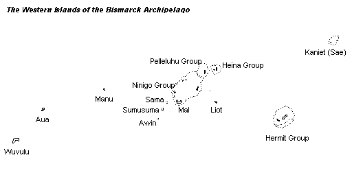
Aua (auch als Durour oder Hunt bezeichnet) ist eine Insel im westlichen Gebiet des Bismarck-Archipels. Administrativ gehört das Eiland zur Provinz Manus in Papua-Neuguinea.

Geographie

Die Insel liegt ca. 900 km nordöstlich von Papua-Neuguineas Hauptstadt Port Moresby und 255 km nordwestlich von der Provinzhauptstadt Manus entfernt. Die nur wenige Meter über dem Meer gelegene Insel ist ca. 7 km² groß. Zur Volkszählung 2000 hatte Aua 419 Einwohner.

Auf Aua gibt es ein Flugfeld mit dem IATA-Flughafencode AUI.

Die Insel ist traditionell in drei Distrikte gegliedert, denen bis 1904 Häuptlinge (puala) vorstanden. Zu der Zeit wurde die Einwohnerzahl von Aua auf 2000 geschätzt. Die Dörfer und Weiler, denen niederrangigere Häuptlinge (päavi) vorstanden, liegen bzw. lagen sämtlich an der Küste:<ref>George Lane Fox Pitt-Rivers: Aua Island: Ethnographical and Sociological Features of a South Sea Pagan Society. The Journal of the Royal Anthropological Institute of Great Britain and Ireland, Vol. 55, (Jul. - Dec., 1925), pp. 425–438</ref>

Diese Siedlungsnamen tauchen in der aktuellen Zensusgeographie nicht mehr auf.

Distrikt Oala
im Nordwesten
Dörfer von Nord nach Süd:
Distrikt Laroaro
im Südwesten
Dörfer von West nach Ost:
Distrikt Bāarafu
im Osten
14 untergegangene Dörfer
  • Tarre
  • Porrei
  • Papuapu
  • Oala
  • Pua
  • Walulo
  • Pirgur
  • Vanura
  • Talapalu
  • Wauapiau
  • Urabarua
  • Mukisisi
  • Folufolo
  • Pallia
  • Aio
  • Bagara zum Vow
  • Bagara zum Mei
  • Valoro
  • Piago (Station)

Bāarafu war einst der bevölkerungsreichste Distrikt, ist heute jedoch unbewohnt. Heute ist Laroaro der bevölkerungsreichste Distrikt. Der puala von Laroaro residierte im Dorf Pirgur.

Geschichte

Die Insel wurde 1545 von dem spanischen Seefahrer Íñigo Ortiz de Retes entdeckt und 1767 von dem Briten Philipp Carteret wiedergefunden.

Ab Ende des 19. Jahrhunderts gehörte die Insel zum Machtbereich der Neuguinea-Kompagnie und wurde, wie auch die Nachbarinsel Wuvulu, von ethnologischen Sammlern aufgesucht. 1899 besuchte Richard Parkinson auf dem Kanonenboot Möwe die Insel. 1902 wurde eine permanente Handelsstation auf der Insel errichtet und Franz Emil Hellwig hielt sich auf der Insel auf. Nachdem Hellwig die Insel im Dezember 1903 verlassen hatte, zerstörten bewaffnete Inselbewohner die Station und töteten den deutschen Händler Otto Reimers. Hintergrund dieser Tat war, dass die Deutschen, nachdem keine weiteren Artefakte auf der Insel vorgefunden wurden, die Gräber verstorbener Inselbewohner geplündert hatten. In der Folge fürchtete die Inselbevölkerung Repressalien durch die deutsche Kolonialmacht und ein Großteil verließ die Insel auf Kanus mit dem Ziel Ninigo-Inseln. Während der Überfahrt kenterten viele Kanus, auch durch Überladung, und etwa 370 Menschen, wohl etwa zwei Fünftel der Bevölkerung Auas ertranken. Die Folge war der kulturelle Niedergang auf der Insel, der von weiteren deutschen Forschern auch wahrgenommen und dokumentiert wurde.

Die Vorkommnisse auf Aua, wie auch auf Wuvulu, gelten heute als Negativbeispiele für das ungebremste und rücksichtslose Entfernen ethnologischer Artefakte durch die (in diesem Fall deutsche) Kolonialmacht, was letztlich Konflikte und einen Niedergang der indigenen Kultur, zumal in einem so begrenzten geographischen Umfeld, verursachte.

Literatur

  • Stichwort: Aua. Online in: Deutsches Kolonial-Lexikon, Band I, Leipzig 1920, S. 94.
  • Michael O’Hanlon, Robert Louis Welsch (Hrsg.): Hunting the Gatherers: Ethnographic Collectors, Agents and Agency in Melanesia, 1870s–1930s. Berghahn Books. New York / Oxford. 2000. ISBN 1-57181-811-1. Seiten 67–73.

Einzelnachweise

<references />

Weblinks